NOAA – Winter Outlook – 2026-2027
Listen to this podcast on any device, CLICK PLAY.
On October 15, 2026, the National Oceanic and Atmospheric Administration (NOAA) released its U.S. Winter Outlook for the period spanning December 2026 through February 2027.
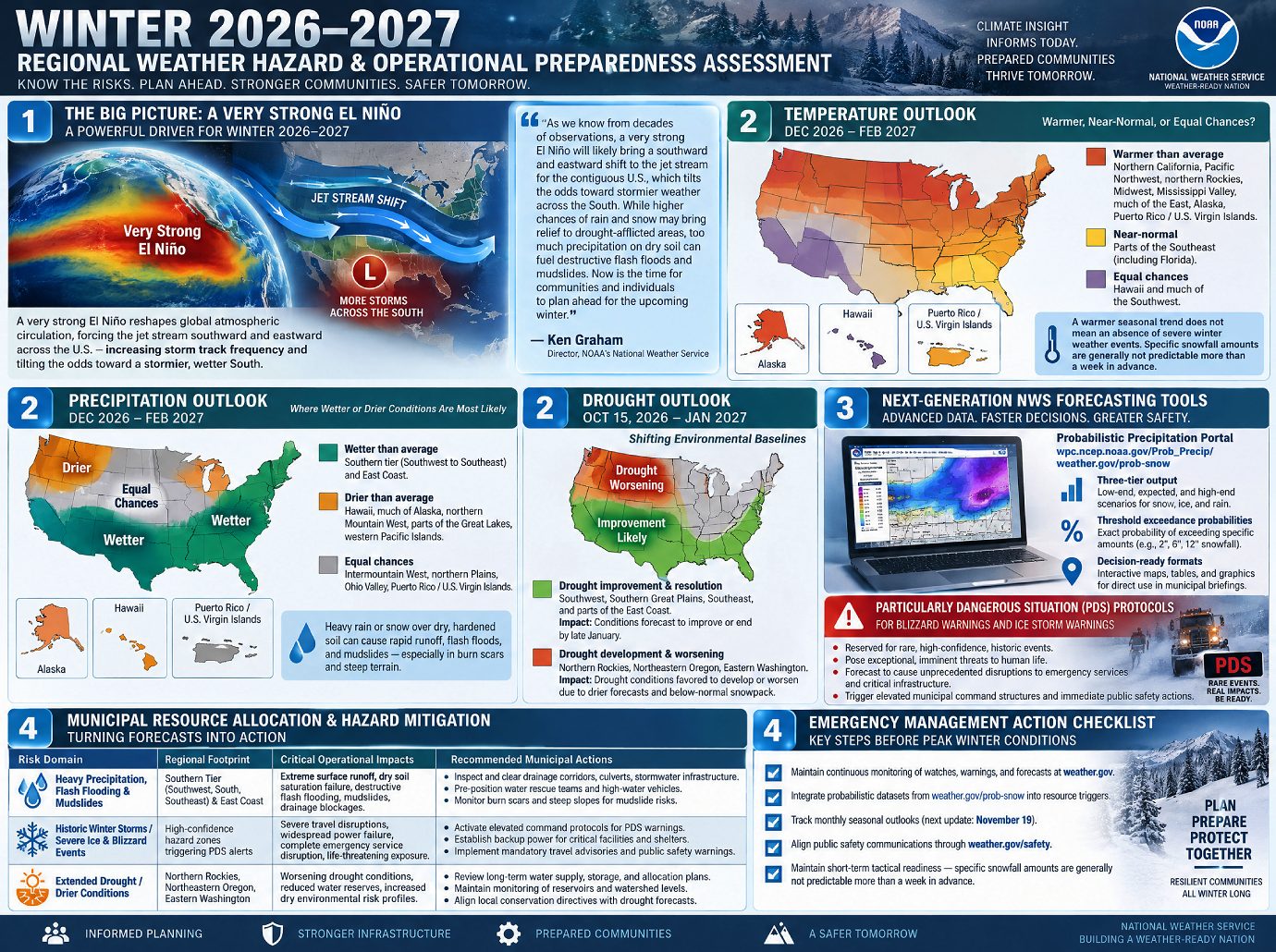
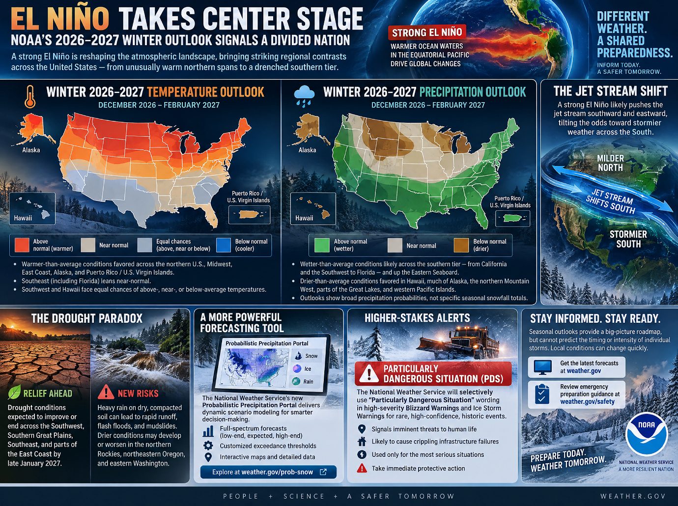
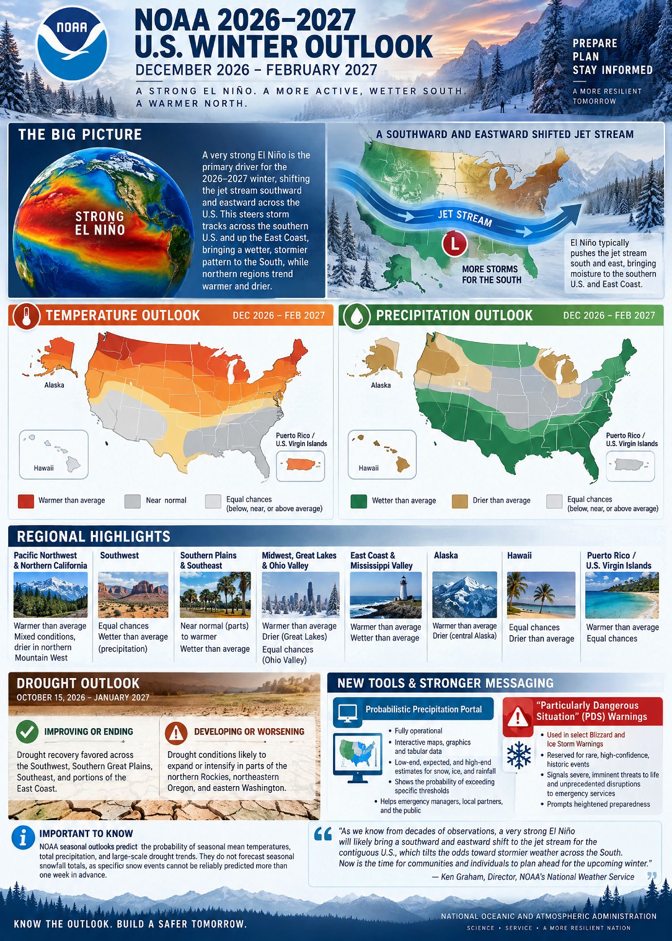
The primary atmospheric driver for the upcoming season is a very strong El Niño, which is anticipated to shift the jet stream southward and eastward across the contiguous United States.
Here’s what the outlook looks like:
Temperature: Warmer-than-average conditions are favored across the northern U.S., Alaska, and U.S. territories, while near-normal temperatures are expected in parts of the Southeast.
Precipitation: Wetter-than-average conditions are expected across the southern tier of the country and along the Eastern Seaboard. Conversely, drier conditions are anticipated in the northern Rockies, Great Lakes, and parts of Alaska.
- Drought Relief vs. Hazards: While increased precipitation is projected to end or improve drought conditions in the Southwest, Southern Great Plains, Southeast, and East Coast, heavy rainfall on dry terrain introduces heightened risks of flash flooding and mudslides. Drought is predicted to worsen in parts of the Pacific Northwest and northern Rockies.
- Tool & Messaging Upgrades: NOAA’s National Weather Service (NWS) has introduced the operational Probabilistic Precipitation Portal and will now utilize “Particularly Dangerous Situation” (PDS) wording in select Blizzard and Ice Storm Warnings for historic, high-confidence events.
Primary Climate Driver: El Niño and Jet Stream Shift
The 2026–2027 winter weather pattern is heavily governed by a strong El Niño climate pattern. According to Ken Graham, Director of NOAA’s National Weather Service:
“As we know from decades of observations, a very strong El Nino will likely bring a southward and eastward shift to the jet stream for the contiguous U.S., which tilts the odds toward stormier weather across the South. While higher chances of rain and snow may bring relief to drought-afflicted areas, too much precipitation on dry soil can fuel destructive flash floods and mudslides. Now is the time for communities and individuals to plan ahead for the upcoming winter.”
This shifting jet stream acts as the primary mechanism redirecting storm tracks, steering moisture across the southern half of the country and up the East Coast, while leaving northern regions warmer and selectively drier.
Seasonal Temperature and Precipitation Forecasts
Temperature Outlook (December 2026 – February 2027)
- Warmer-than-Average: Favored for the Pacific Northwest, northern California, northern Rockies, Midwest, Mississippi Valley, much of the East Coast, Alaska, and Puerto Rico / U.S. Virgin Islands.
- Near-Normal: Most likely for parts of the Southeast, including Florida.
- Equal Chances (Below-, Near-, or Above-Average): Hawaii and much of the Southwest exhibit equal likelihoods across all temperature categories.
Precipitation Outlook (December 2026 – February 2027)
- Wetter-than-Average: Most likely across the southern tier of the U.S. (extending from California through the Southwest to the Southeast) and along the East Coast.
- Drier-than-Average: Elevated odds for the northern Mountain West/northern Rockies, some areas in the Great Lakes, central Alaska, Hawaii, and the western Pacific Islands.
- Equal Chances (Below-, Near-, or Above-Average): Intermountain West, northern Plains, Ohio Valley, and Puerto Rico / U.S. Virgin Islands.
Drought Expectations (October 15, 2026 – January 2027)
The anticipated shift in precipitation patterns substantially alters the national drought footprint:
- Improving or Ending Drought: Strong probabilities of drought recovery across the Southwest, Southern Great Plains, Southeast, and portions of the East Coast.
- Developing or Worsening Drought: Drought conditions are favored to expand or intensify across parts of the northern Rockies, as well as northeastern Oregon and eastern Washington.
Operational Upgrades and Forecasting Innovations
NOAA’s National Weather Service has deployed two major updates for the 2026–2027 winter season to enhance decision support and hazard communication:
- Probabilistic Precipitation Portal
- Status: Fully operational.
- Capabilities: Provides interactive graphics, maps, and tabular data detailing low-end, expected, and high-end estimates for snow, ice, and rainfall accumulations.
- Purpose: Assists emergency managers, local partners, and the public by mapping the probability of precipitation exceeding specific operational thresholds.
- “Particularly Dangerous Situation” (PDS) Warning Language
- Implementation: Integrated into select Blizzard Warnings and Ice Storm Warnings.
- Trigger: Reserved for rare, high-confidence winter storms of historic severity.
- Objective: Clearly communicate severe, imminent threats to life and unprecedented disruptions to emergency services, prompting heightened preparedness.
Programmatic Constraints and Future Updates
- Predictability Limits: NOAA seasonal outlooks project the probability of seasonal mean temperatures and total precipitation amounts, as well as large-scale drought trends. They do not forecast seasonal snowfall totals, as specific snow events cannot be reliably predicted more than one week in advance.
- Update Schedule: The Climate Prediction Center / Weather Prediction Center updates the three-month outlook monthly. The next official update following this release is scheduled for November 19, 2026.