


Gardner MA Engineering Department Plans for Worst-Case Flood Scenario
In a Public Service Committee meeting of October 13, 2022 the City Engineer announced that the City of Gardner has been awarded a $50,000 Community Compact Grant from the State to look at Crystal Lake. The proactive study is to look at options for protecting lower lying sections of the Chair City including Downtown in the event of a major Hurricane event. The worry is that a hurricane could cause flooding on Park Street and to the Center of Downtown. Grant would look at the feasibility of structural options, including possibly creating a spillway. This issue was looked at sometime in the 1980s and before that in the 1960s but no action was take at that time. To give you an idea as to size, Crystal lake is 156 acres. In contrast, the Perley Brook Reservoir is 55 acres. What is the historical risk of a Major Hurricane. The last hurricane causing major loss of life in New England was in 1938, but there have been others. List of New England Hurricanes:
Many communities around the country are looking at unlikely scenarios given that the climate has been somewhat unpredictable of late. As far as elevations go, the Greenwood Pool at 69 Park street is 1,093 feet above sea level. Other elevations: City Hall 1.076 feet,, 8 Parker Street 1,079 feet, Paramount Cafe 46 Main street, 1,070 feet, Kenny’s Chinese: 130 Parker Street 1,060 feet, and Levi Heywood Memorial library 55 West Lynde Street is at 1,089 feet. In contrast Heywood Hospital is about 100 feet higher at 1181 feet. In the Chair City, elevations range from just over 900 feet near the Otter River to 1300 feet at the crest of Reservoir Hill. If you want to get the elevation at your address, CLICK HERE.
What can communities do about future flood risks? According to riskfactor.com, it will require cooperation of individuals, mayors, governors, and Congress “to build protections before flooding, build back stronger after flooding, and create plans that future-proof communities.” It’s interesting to learn what communities at much greater risk around the country do to protect themselves. Here is a Flood zone planning tool
Across the country, here’s an explanation as to why flood risks are increasing.
Flood Risks in MA
FYI: Over 400,000 Massachusetts residents currently live in a 100-year flood zone, which means more than a 1 in 4 chance of a flood during a 30 year mortgage period.
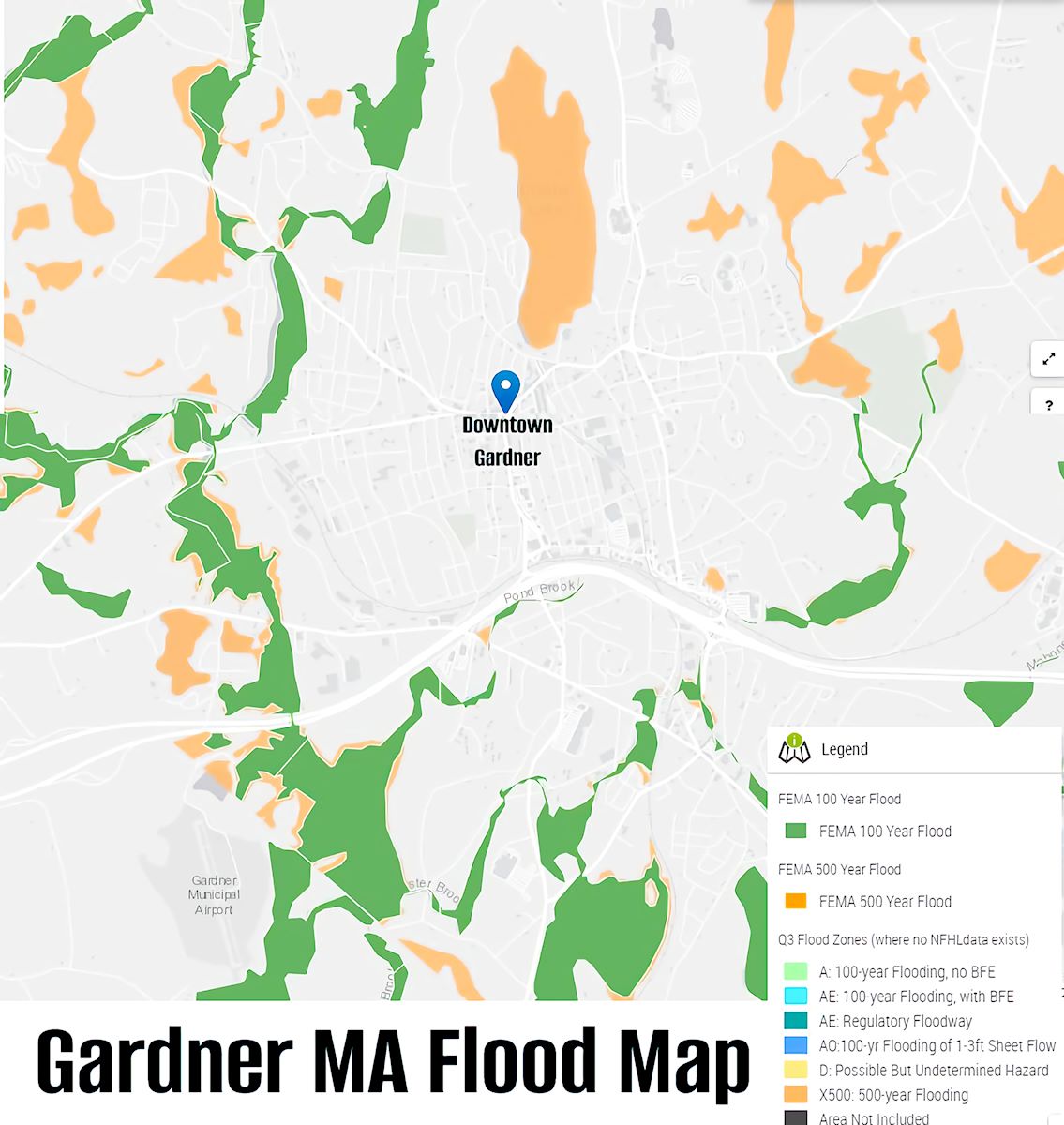
Also according to the 2015 Gardner Open Space Plan on Flood Hazard areas stated, “The Federal Emergency Management Agency’s (FEMA) Flood Insurance Rate Map for the City of Gardner indicates flood prone areas. Gardner, with its relatively steep slopes and drainage characteristics, has well defined flood prone areas. The abundance of wetland areas provides large amounts of natural storage, thus reducing flood dangers downstream. Flooding sources studied include the Otter River, Perley Brook, Wilder Brook, Pond Brook, Baker Brook, Foster Brook, and Greenwood Brook. “
According to the 2015 Gardner Open Space plan, “Gardner’s water treatment facilities have all been constructed or upgraded since 2000. Our surface water treatment facility at Crystal Lake is still by today’s standards, state of the art. Crystal Lake is responsible for providing the City with 30-40% of its drinking water from April to November. The secondary source of drinking water in the City is the Snake Pond groundwater treatment facility constructed in 2000 and located in the south eastern area of the City. The current focus continues replacement of aged water mains, many at or near 100 years old, to better control and mitigate losses in the distribution system and thereby conserve water resources and maintain or increase revenues.” Complete copy of Gardner Open Space Plan 2015, CLICK HERE – Gardner Bio Map from 2012, CLICK HERE
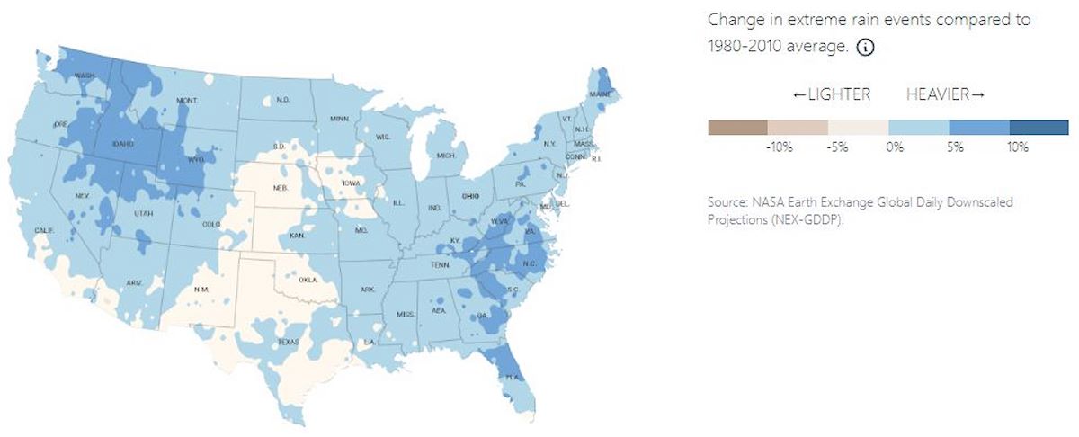
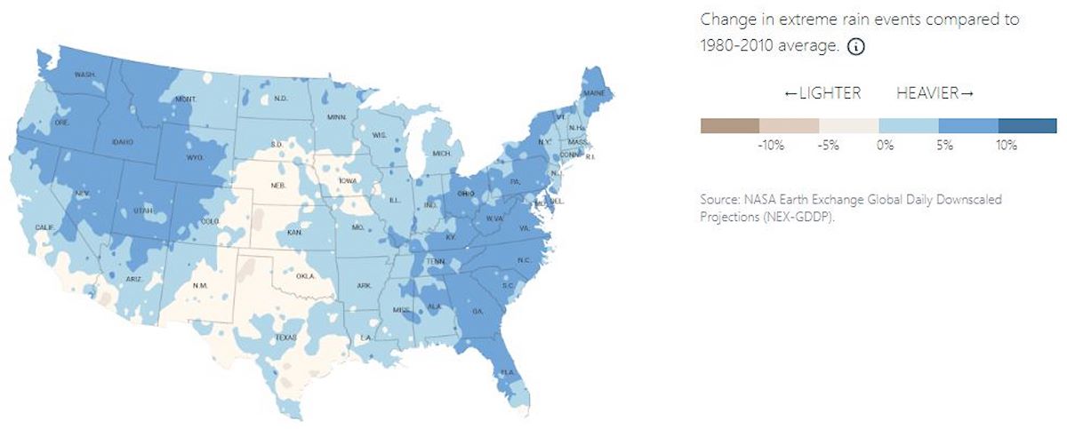
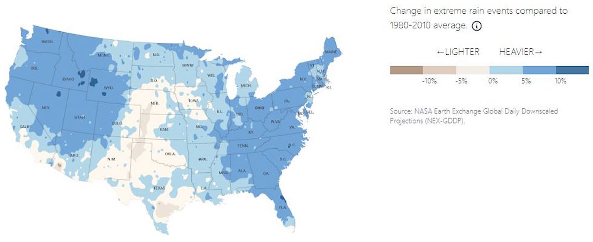
Rain Maps
The 3 Rain Maps at left show a prediction of rain events this year, in 15 years, and in 30 years. In the Massachusetts area, it is predicted there will be more severe rain events in 30 years. CLICK on any of the images for a larger, easy-to-read view.