


New Salem MA Detailed History and Overview
New Salem MA Community Snapshot – History – and Interesting Facts
Listen to a complete “Deep Dive” on any device, CLICK PLAY.
Town Profile: An Overview of New Salem
A Historical Brief: The Geographical and Demographical Transformation of New Salem, Massachusetts
How a Reservoir Accidentally Created the Largest Town in Western Massachusetts
How Water Reshaped a Town: The Story of New Salem and the Quabbin Reservoir
Town Profile: New Salem, Massachusetts
Town Profile: New Salem, Massachusetts
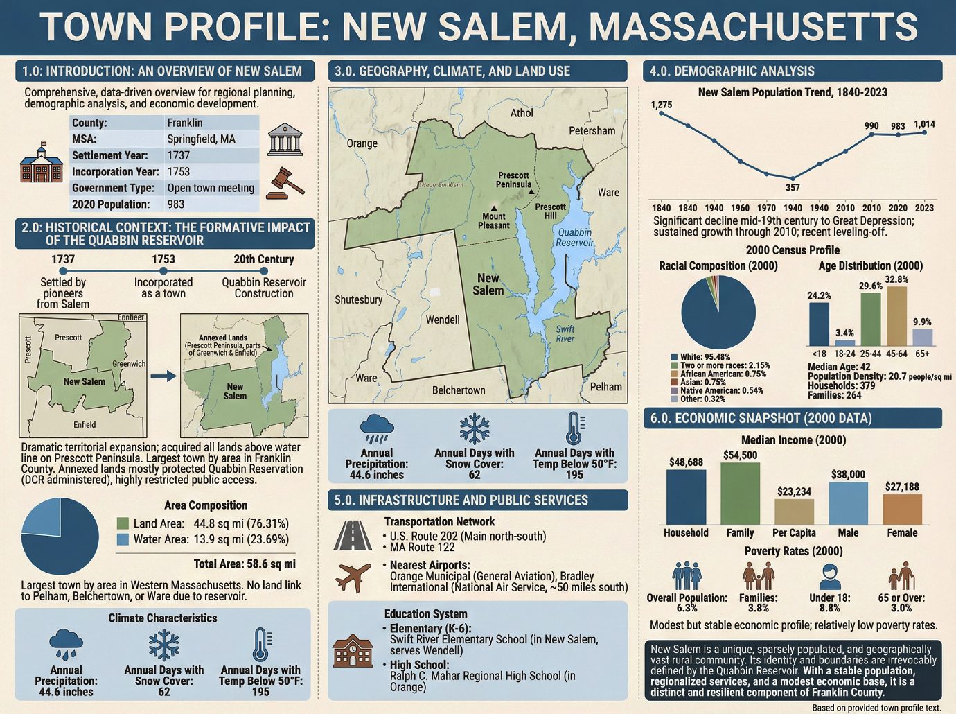
1.0 Introduction: An Overview of New Salem
This profile provides a comprehensive, data-driven overview of the Town of New Salem, intended to support regional planning, demographic analysis, and economic development initiatives. By synthesizing key historical, geographical, and socioeconomic data, this document serves as a foundational resource for understanding the town’s unique characteristics and its position within the broader regional context. Its core attributes are summarized below:
• County: Franklin
• Metropolitan Statistical Area: Springfield, Massachusetts
• Year of Settlement: 1737
• Year of Incorporation: 1753
• Government Type: Open town meeting
• 2020 Population: 983
The town’s modern identity cannot be fully understood without examining the historical context that has fundamentally reshaped its physical and political boundaries.
2.0 Historical Context: The Formative Impact of the Quabbin Reservoir
A deep understanding of New Salem’s history is essential for effective planning, as the town’s modern geography and character were decisively shaped by the construction of the Quabbin Reservoir in the 20th century. This single event dramatically expanded its territory while simultaneously isolating it from former neighbors.
New Salem was first settled in 1737 by pioneers from Salem, Massachusetts, and was officially incorporated as a town in 1753. For nearly two centuries, it developed as a typical rural New England community. However, the creation of the Quabbin Reservoir led to a profound jurisdictional and geographical transformation. With the formation of the reservoir, New Salem acquired all lands above the water line on the resulting Prescott Peninsula, as the town provided the only land connection to the area. This annexation included most of the former town of Prescott and parts of Greenwich and Enfield, making New Salem the largest town by total area in Franklin County. This annexation was particularly significant as the northern half of the former town of Prescott had originally been part of New Salem before its own incorporation.
Today, the annexed lands are almost entirely part of the protected Quabbin Reservation, which is administered by the Massachusetts Department of Conservation & Recreation (DCR). Public access to this large portion of the town is highly restricted, a factor that preserves its natural state but also limits its use. This historical reshaping of the town’s boundaries directly informs its current geographical profile and land use patterns.
3.0 Geography, Climate, and Land Use
A community’s physical geography and climate are foundational elements for any planning effort, influencing land use, infrastructure requirements, and regional identity. New Salem is characterized by its vast area, significant water bodies, and a classic New England climate.
3.1 Geographic Profile
New Salem’s annexation of lands from the former “lost towns” of the Quabbin Valley gives it a unique and expansive geographic footprint.
• Total Area: 58.6 sq mi (151.9 km²)
• Land Area: 44.8 sq mi (116.0 km²)
• Water Area: 13.9 sq mi (36.0 km²), constituting 23.69% of the total area.
As a result of this configuration, New Salem is the largest town by area not only in Franklin County but in all of Western Massachusetts. The town’s dominant geographical features include the Prescott Peninsula, which contains its highest points at Mount Pleasant and Prescott Hill. Its southern boundaries are now uniquely defined by the submerged branches of the Swift River, which form two forks of the Quabbin Reservoir.
The town is bordered by Orange to the north, Athol to the northeast, Petersham to the east, Ware to the south, Belchertown to the southeast, and Pelham, Shutesbury and Wendell to the west. Because of the reservoir, there is no land link between New Salem and the towns of Pelham, Belchertown, or Ware.
3.2 Climate Characteristics
The town’s climate provides a clear environmental baseline for planning related to public works, agriculture, and seasonal tourism.
• Annual Precipitation: 44.6 inches
• Annual Days with Snow Cover: 62
• Annual Days with Temperature Below 50°F: 195
The town’s physical layout and climatic conditions provide the setting for the small but enduring population that calls New Salem home.
4.0 Demographic Analysis
A detailed demographic analysis is critical for understanding the community’s composition, needs, and long-term trends. This data provides an essential foundation for social, educational, and economic planning efforts.
4.1 Historical Population Trends
New Salem’s population has experienced significant shifts over the past two centuries, characterized by a long period of decline followed by steady recovery and recent stability.
New Salem Population, 1840-2023
| Year | Population |
|---|---|
| 1840 | 1,275 |
| 1850 | 1,253 |
| 1860 | 957 |
| 1870 | 987 |
| 1880 | 869 |
| 1890 | 856 |
| 1900 | 807 |
| 1910 | 639 |
| 1920 | 512 |
| 1930 | 414 |
| 1940 | 357 |
| 1950 | 392 |
| 1960 | 397 |
| 1970 | 474 |
| 1980 | 688 |
| 1990 | 802 |
| 2000 | 929 |
| 2010 | 990 |
| 2020 | 983 |
| 2023 | 1,014 |
The data reveals a significant population decline from the mid-19th century through the Great Depression, reaching a low point of just 357 residents in 1940. This was followed by a period of sustained, multi-decade growth through 2010. The most recent figures from 2020 and 2023 suggest a leveling-off of this growth trend, with the population hovering around 1,000 residents.
4.2 2000 Census Profile
The 2000 U.S. Census provides a detailed snapshot of the town’s composition at the turn of the century.
Population and Density With a total population of 929, New Salem’s population density was just 20.7 people per square mile, reflecting its rural character and expansive geography.
Household and Family Structure The town consisted of 379 households, of which 264 were classified as families. Married couples living together represented 59.6% of all households, while 30.3% had children under 18 present. Non-family households made up 30.3% of the total.
Racial and Ethnic Composition The racial makeup of the town was predominantly White, with minimal representation from other groups.
• White: 95.48%
• Two or more races: 2.15%
• African American: 0.75%
• Asian: 0.75%
• Native American: 0.54%
• Other races: 0.32% Individuals identifying as Hispanic or Latino of any race constituted 0.86% of the population.
Age Distribution and Median Age The population was spread across a mature age range, with a median age of 42 years. The distribution included 24.2% of residents under the age of 18, 3.4% from 18 to 24, 29.6% from 25 to 44, 32.8% from 45 to 64, and 9.9% who were 65 years of age or older.
This demographic profile provides context for the public infrastructure and services that support the town’s residents.
5.0 Infrastructure and Public Services
Transportation networks and educational systems are fundamental to a community’s connectivity, quality of life, and potential for future development. New Salem relies on regional road networks and a multi-town school system to serve its population.
5.1 Transportation Network
The town’s primary road access is provided by U.S. Route 202, which serves as the main north-south thoroughfare connecting New Salem to Pelham and Orange. Massachusetts Route 122 also passes through the town, running concurrently with Route 202 in its northern section before splitting off. There are no interstates or other limited-access highways within the town’s borders.
For air travel, the nearest facilities are:
• General Aviation: Orange Municipal Airport, located just north of the town.
• National Air Service: Bradley International Airport in Connecticut, situated approximately 50 miles to the south.
5.2 Education System
New Salem participates in a regionalized public education system to serve its student population.
• Elementary school students (grades K-6) attend the Swift River Elementary School, which is located in New Salem and also serves the neighboring town of Wendell.
• High school students attend Ralph C. Mahar Regional High School, located in the nearby town of Orange.
The town’s infrastructure connects its residents to regional centers for commerce and education, which are directly linked to their economic well-being.
6.0 Economic Snapshot (2000 Data)
This section provides an economic baseline for the community using key income and poverty metrics from the 2000 Census. This data is foundational for assessing the town’s historical economic health and identifying areas for future development and support.
The median income figures from 2000 indicate a modest but stable economic profile for the town’s households and families.
• Median Household Income: $48,688
• Median Family Income: $54,500
• Per Capita Income: $23,234
• Median Male Income: $38,000
• Median Female Income: $27,188
During the same period, poverty rates in New Salem were relatively low. The overall poverty rate for the population stood at 6.3%, with 3.8% of families living below the poverty line. For specific age cohorts, 8.8% of residents under age 18 and 3.0% of those age 65 or over were below the poverty line.
In summary, New Salem presents a unique profile as a sparsely populated but geographically vast rural community. Its identity, boundaries, and land use have been irrevocably defined by the historical creation of the Quabbin Reservoir. With a stable population, regionalized public services, and a modest economic base, the town stands as a distinct and resilient component of the Franklin County region. ——————-
A Historical Brief: The Geographical and Demographical Transformation of New Salem, Massachusetts
A Historical Brief: The Geographical and Demographical Transformation of New Salem, Massachusetts
1.0 Introduction: A Town Redefined by Water
Established in the 18th century, the town of New Salem, Massachusetts, possesses a history that mirrors that of many small New England communities. However, its modern identity, geography, and demographic profile were fundamentally forged not by centuries of slow evolution, but by a single, monumental public works project of the 20th century—the creation of the Quabbin Reservoir. This brief will analyze the profound transformation of New Salem through this event, examining the unprecedented expansion of its land area through annexation, the resulting shifts in its population, and its ultimate emergence as a town intrinsically and permanently linked to the Quabbin Reservation.
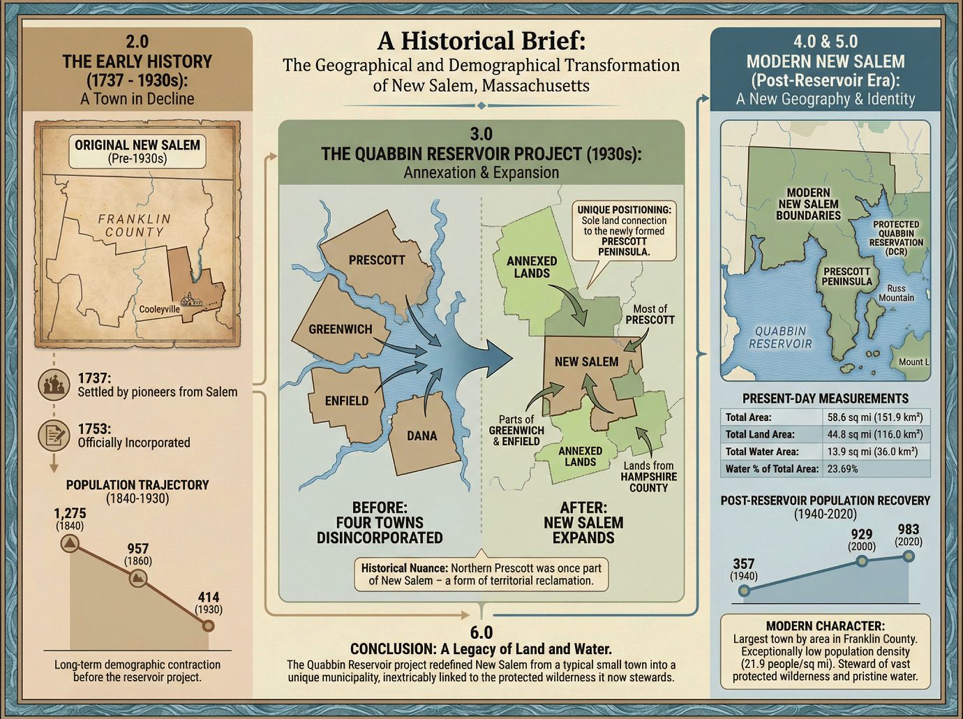
2.0 The Early History of New Salem (1737 – 1930s)
To fully appreciate the scale of the changes wrought by the Quabbin Reservoir, it is essential to first understand the town’s original geography and demographic trajectory. New Salem’s early development was characteristic of its era, but its pre-reservoir boundaries and a long-term trend of population decline set the stage for a radical redefinition in the 20th century.
The town’s origins trace back to its first settlement in 1737 by pioneers from Salem, for whom the new community was named. It was officially incorporated sixteen years later, in 1753. Geographically, the original town of New Salem occupied the southeastern corner of Franklin County, with its southern boundary not extending much further than the present-day village of Cooleyville. This configuration placed it as a distinct, moderately-sized rural community.
Historical population data reveals a community in a state of protracted decline for the 90 years preceding the reservoir project. After peaking at 1,275 residents in 1840, New Salem began a significant and lengthy demographic contraction. By 1860, the population had fallen by nearly 25% to 957 residents. This downward trend continued for the next seventy years, with the town’s population dwindling to just 414 by 1930. It was this trajectory of decline that the Quabbin Reservoir project would first accelerate and then fundamentally alter, setting the town on an entirely new course.
3.0 The Quabbin Reservoir Project: Annexation and Expansion
The construction of the Quabbin Reservoir in the 1930s was not merely an engineering project but a profound act of state-level re-engineering of the central Massachusetts landscape. Four entire towns were disincorporated to make way for the massive body of water that would serve Boston. For New Salem, however, this process resulted in an unprecedented and dramatic territorial expansion. While its neighbors vanished beneath the rising waters, New Salem’s geography “benefited greatly,” as it received all lands situated above the water line between the reservoir’s newly formed western and middle forks. This unique positioning made it the sole land connection to the large, newly formed Prescott Peninsula.
The town’s expansion was achieved through the formal annexation of lands from disincorporated towns and a shift in county lines. The specific territorial acquisitions included:
• Most of the former town of Prescott.
• Parts of the former towns of Greenwich and Enfield.
• Lands that were formerly part of Hampshire County.
Adding a layer of historical nuance to this event, the northern half of the town of Prescott had once belonged to New Salem before its own incorporation, making its annexation a form of territorial reclamation. This process of annexation fundamentally redrew the map, leading to the profound and lasting geographical characteristics that define the town today.
4.0 A New Geography: The Modern Boundaries and Character of New Salem
The town’s new geography is its defining modern feature. The addition of the Prescott Peninsula did not just increase New Salem’s acreage; it fundamentally changed its physical character, its relationship with neighboring counties, and its internal land-use profile. The sheer scale of this transformation is best illustrated by its present-day measurements.
| Metric | Measurement (sq mi) | Measurement (km²) |
|---|---|---|
| Total Area | 58.6 | 151.9 |
| Total Land Area | 44.8 | 116.0 |
| Total Water Area | 13.9 | 36.0 |
Water now constitutes 23.69% of the town’s total area. This expansion made New Salem the largest town by area in Franklin County and the largest community by area in all of western Massachusetts. Its new southern town lines are no longer straight survey lines but are dictated by the natural contours of the submerged former West and Middle Branches of the Swift River. A profound cartographic consequence of these new water boundaries is that there is now no land link between New Salem and the towns of Pelham, Belchertown, or Ware.
Critically, the character of this newly acquired land is unique. The vast majority of the annexed territory, including the Prescott Peninsula, is now part of the protected Quabbin Reservation, administered by the Massachusetts Department of Conservation & Recreation (DCR). The peninsula contains the highest points in town, at Mount Pleasant and Prescott Hill, and the town also owns several islands within the reservoir, including those around Russ Mountain and Mount L. These lands are strictly off-limits to the public, preserving a vast wilderness area at the heart of the town. Access is highly restricted, with one of the only exceptions being an annual bus tour of the peninsula for members of the Swift River Historical Society. This transformation of thousands of acres from private towns to a protected, inaccessible public watershed permanently altered New Salem’s civic character, setting the stage for the unique demographic profile that defines it today.
5.0 Demographic Evolution in the Post-Reservoir Era
The demographic impact of the Quabbin Reservoir project on New Salem was paradoxical. While the town’s land area grew exponentially, its population initially declined further before embarking on a slow, steady recovery in the latter half of the 20th century. This has resulted in the exceptionally low-density community that exists today.
During the peak of the reservoir’s construction and the disincorporation of neighboring communities, New Salem’s population hit its lowest recorded point, falling to just 357 residents by 1940. Following this trough, the town began a period of gradual but consistent growth. Over the next several decades, the population steadily increased, reaching 929 by the year 2000 and culminating in a 2020 census population of 983.
Synthesizing this demographic data with the town’s expanded geography reveals its modern character. With a 2020 population of 983 spread across 44.8 square miles of land, New Salem has a population density of just 21.9 people per square mile (8.47/km²). This sparse density is a direct and enduring legacy of the Quabbin project, which bequeathed the town a vast, uninhabited, and protected landscape that dominates its southern half.
6.0 Conclusion: A Legacy of Land and Water
The creation of the Quabbin Reservoir stands as the single most defining event in the history of New Salem. More than any other factor, this massive undertaking arrested a century of population decline and radically transformed the town’s physical and civic identity. The project redefined New Salem from a typical, small New England town into a unique municipality whose vast geography and low population density are inextricably linked to the Quabbin. The great paradox of New Salem’s history is that a project designed to serve a distant metropolis ultimately forged the town’s modern local identity, transforming it into the quiet steward of one of the largest tracts of protected wilderness and pristine water in Southern New England.
——————-
How a Reservoir Accidentally Created the Largest Town in Western Massachusetts
How a Reservoir Accidentally Created the Largest Town in Western Massachusetts
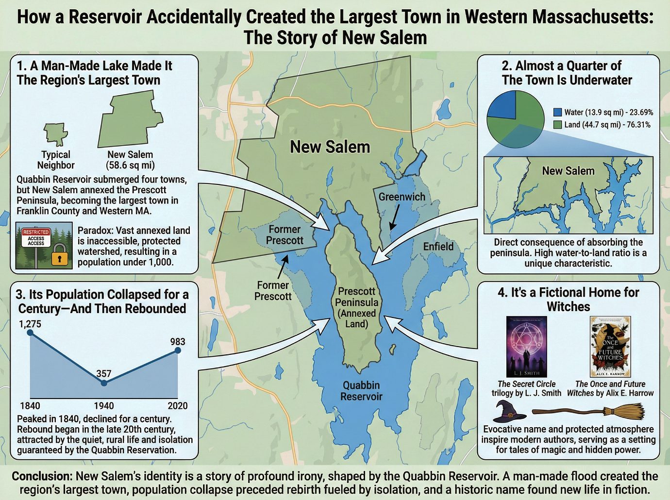
Small New England towns are often treasure troves of hidden history, but few have a story as strange and counter-intuitive as New Salem, Massachusetts. Tucked away in Franklin County, this quiet community’s modern identity was forged by a single, massive 20th-century event that paradoxically erased its neighbors while expanding its own borders to a surprising new scale.
1. A Man-Made Lake Made It The Region’s Largest Town
The construction of the Quabbin Reservoir in the early 20th century was a monumental undertaking that submerged four entire towns to provide water for Boston. But for New Salem, the deluge was a baptism. The creation of the reservoir made New Salem the largest town by total area (58.6 sq mi) not only in Franklin County but in all of western Massachusetts. While its neighbors were wiped off the map, New Salem actually gained territory by annexing the lands of the newly formed Prescott Peninsula—lands that were formerly parts of Prescott, Greenwich, and Enfield. The project’s transformative power was so complete that it literally moved a piece of Hampshire County into Franklin County along with the new territory.
But the official records show one thing, while the story on the ground is even more fascinating. This “largest town” status is a geographic technicality, as the vast majority of the annexed land is inaccessible, protected watershed as part of the Quabbin Reservation, which resolves the paradox of why a town so huge has a population of under 1,000 people.
2. Almost a Quarter of The Town Is Underwater
A direct consequence of absorbing the peninsula is that a significant portion of New Salem is now submerged. Of the town’s 58.6 square mile total area, 13.9 square miles are water. This means an astonishing 23.69% of the town is underwater, a direct result of the Quabbin Reservoir defining its new southern border along the flooded branches of the Swift River. This incredibly high water-to-land ratio is a highly unusual characteristic for any municipality and stands as a defining feature of New Salem’s unique landscape.
3. Its Population Collapsed for a Century—And Then Rebounded
New Salem’s demographic curve tells a classic New England story of rural decline and eventual rebirth. The town’s population peaked in 1840 at 1,275 residents before entering a century-long decline, a fate shared by many agricultural towns in the region. By 1940, it had dwindled to a low of just 357 people. But just as the town seemed on the verge of fading away, its fortunes reversed. The population began a steady recovery through the latter half of the 20th century, climbing back to 983 by 2020. This rebound is tied directly to the town’s geography; the very isolation and protected natural beauty guaranteed by the Quabbin Reservation began to attract new residents seeking the quiet, rural life that New Salem now permanently embodies.
4. It’s a Fictional Home for Witches
Despite its small population, New Salem has captured the imagination of modern authors. The town serves as the primary setting for multiple works of fiction, most notably The Secret Circle trilogy by L. J. Smith and the New York Times bestseller The Once and Future Witches by Alix E. Harrow. The choice is likely no accident. The town’s evocative name, recalling the infamous history of the original Salem, combined with its quiet, protected atmosphere, provides a compelling backdrop for tales of magic and hidden power thriving in the New England woods.
Conclusion
New Salem’s identity is a story of profound irony, inextricably linked to the creation of the Quabbin Reservoir. A man-made flood created the region’s largest town, a century of population collapse preceded a rebirth fueled by the town’s newfound isolation, and a historic name found new life in fictional witchcraft. It is a powerful reminder of how history can shape a place in the most unexpected ways. What hidden histories might be shaping the places we call home?
—————-
How Water Reshaped a Town: The Story of New Salem and the Quabbin Reservoir
How Water Reshaped a Town: The Story of New Salem and the Quabbin Reservoir
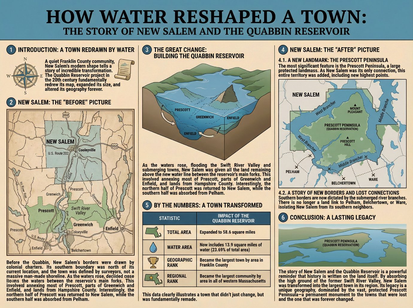
1. Introduction: A Town Redrawn by Water
The maps we use every day often hold hidden stories, and as a local historian, I find the map of New Salem, Massachusetts, tells one of the most dramatic. At first glance, it appears to be a quiet community in Franklin County, but its modern shape tells a story of incredible transformation. The construction of the Quabbin Reservoir in the 20th century was a monumental undertaking that provided water for millions, but for New Salem, it did something more. It didn’t just bring water to the town’s border; it fundamentally redrew its map, expanded its size, and altered its geography forever.
To truly understand the scale of this change, we must first look at what New Salem was like before this massive project began.
2. New Salem: The “Before” Picture
Before the Quabbin Reservoir existed, New Salem’s geography was quite different. While it has always occupied the southeastern corner of Franklin County, its southern boundary was located much further north than it is today. The original town limits didn’t extend much beyond the area around the village of Cooleyville, a community that now lies along U.S. Route 202. This was a town whose borders were drawn by surveyors and colonial charters, not yet by the massive, man-made shoreline that would later define it.
This was the landscape that was about to be permanently altered by one of the most ambitious public works projects in the state’s history.
3. The Great Change: Building the Quabbin Reservoir
The creation of the Quabbin Reservoir was the pivotal event that reshaped New Salem. As the waters rose, they flooded the Swift River Valley, submerging entire towns like Prescott, Greenwich, and Enfield. For New Salem, this event triggered a massive expansion. The town was given all the land that remained above the new water line between the two main forks of the reservoir. The reason for this was simple: New Salem provided the only remaining land connection to this newly formed peninsula.
This process involved annexing a significant amount of territory, including:
• Most of the former town of Prescott.
• Parts of the former towns of Greenwich and Enfield.
• Lands that were previously located in Hampshire County.
What makes this story even more fascinating is the history of the land itself. In a strange twist, the northern half of Prescott had once belonged to New Salem, so the reservoir project, in a way, returned old land to the town. At the same time, the southern half of Prescott had originally been part of Pelham, meaning New Salem also absorbed territory from a completely different community, setting the stage for the town we see on the map today.
4. New Salem: The “After” Picture
The results of this annexation were profound, creating a new geography with distinct features, borders, and a completely new scale.
4.1. A New Landmark: The Prescott Peninsula
The most significant new feature is the Prescott Peninsula, a large landmass situated between the west and middle branches of the reservoir. Because New Salem was its only connection to the rest of Massachusetts, this entire territory was added to the town. This peninsula is now a protected part of the Quabbin Reservation, largely off-limits to the public. It also contains the town’s new highest points, including Mount Pleasant and Prescott Hill—the latter of which was originally part of Pelham, further illustrating the dramatic reorganization of the landscape.
4.2. A Story of New Borders and Lost Connections
With the valley flooded, New Salem’s southern borders were completely redefined. They are no longer lines on a surveyor’s map but are now dictated by the submerged West and Middle Branches of the Swift River. This created a critical and lasting consequence for regional travel: there is no longer a land link between New Salem and the towns of Pelham, Belchertown, or Ware. The water that expanded New Salem also isolated it from its southern neighbors.
4.3. By the Numbers: A Town Transformed
The geographic impact of the reservoir on New Salem is striking when you look at the numbers. The annexation of the Prescott Peninsula and surrounding lands dramatically increased the town’s size and stature.
New Salem’s Transformation: By the Numbers
| Statistic | Impact of the Quabbin Reservoir |
|---|---|
| Total Area | Expanded to 58.6 square miles. |
| Water Area | Now includes 13.9 square miles of water (23.69% of total area). |
| Geographic Rank | Became the largest town by area in Franklin County. |
| Regional Rank | Became the largest community by area in all of western Massachusetts (Hampden, Hampshire, Franklin, and Berkshire counties). |
This data clearly illustrates a town that didn’t just change, but was fundamentally remade.
5. Conclusion: A Lasting Legacy
The story of New Salem and the Quabbin Reservoir is a powerful reminder that history is written on the land itself. The project did far more than flood towns to create a water supply; it redefined an existing one. By absorbing the high ground of the former Swift River Valley, New Salem was transformed from a town of modest size into the largest in its county and region. Its legacy is a unique geography, dominated by the vast, protected, and largely inaccessible Prescott Peninsula—a permanent monument to the towns that were lost and the one that was forever changed.
—————-
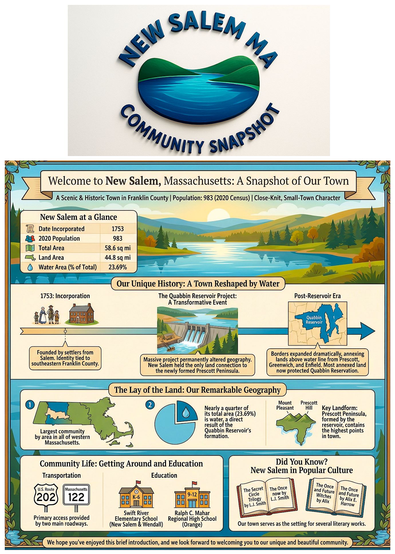
Welcome to New Salem, Massachusetts: A Snapshot of Our Town
Welcome to New Salem, Massachusetts: A Snapshot of Our Town
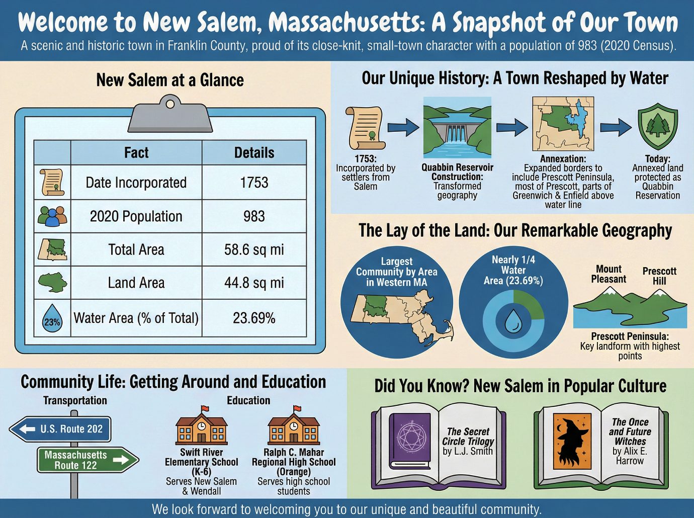
Welcome to New Salem, a scenic and historic town located in Franklin County, Massachusetts. With a population of just 983 people as of the 2020 census, we pride ourselves on our close-knit, small-town character, and we’re glad to share a few facts to help you get acquainted with our home.
New Salem at a Glance
| Fact | Details |
|---|---|
| Date Incorporated | 1753 |
| 2020 Population | 983 |
| Total Area | 58.6 sq mi |
| Land Area | 44.8 sq mi |
| Water Area (% of Total) | 23.69% |
But these statistics are only the beginning of a story forged by the most transformative event in our history.
Our Unique History: A Town Reshaped by Water
Founded by settlers from Salem, our town was officially incorporated in 1753. For nearly two centuries, New Salem’s identity was tied to the southeastern corner of Franklin County. This changed forever with the construction of the Quabbin Reservoir, a massive project that permanently altered our geography. Because New Salem held the only land connection to the newly formed Prescott Peninsula, our town’s borders expanded dramatically, annexing all lands above the new water line. This included most of the former town of Prescott and parts of Greenwich and Enfield.
Today, the vast majority of this annexed land is protected as part of the Quabbin Reservation, preserved for its natural beauty and historical significance. The creation of the reservoir has left a lasting mark on our landscape, shaping the remarkable geography we see today.
The Lay of the Land: Our Remarkable Geography
New Salem is defined by two significant geographical features that make it stand out:
1. It is the largest community by area in all of western Massachusetts.
2. Nearly a quarter of its total area (23.69%) is water, a direct result of the Quabbin Reservoir’s formation.
A key local landform is the Prescott Peninsula, which was formed by the reservoir and contains the highest points in town, Mount Pleasant and Prescott Hill. The town itself is a vibrant community, connected by essential services for our residents.
Community Life: Getting Around and Education
Transportation
Access to New Salem is primarily provided by two main roadways:
• U.S. Route 202
• Massachusetts Route 122
Education
Our public school system serves students from kindergarten through high school. Younger students (grades K-6) from New Salem and the neighboring town of Wendall attend the Swift River Elementary School. High school students attend the Ralph C. Mahar Regional High School in Orange.
Did You Know? New Salem in Popular Culture
Our town serves as the setting for several literary works, including L.J. Smith’s trilogy The Secret Circle and the New York Times bestseller The Once and Future Witches by Alix E. Harrow.
We hope you’ve enjoyed this brief introduction, and we look forward to welcoming you to our unique and beautiful community.