


The Evolution of Ashburnham Massachusetts
Exploring Ashburnham MA Through History
This page takes us through the evolution of Ashburnham from Frontier Plantation to Modern Town. We have a “Deep Dive” which goes through it all. Listen on any device, CLICK PLAY.
Complete History of Ashburnham: Evolution of Ashburnham: From Frontier Plantation to Modern Town.
Evolution of Ashburnham: From Frontier Plantation to Modern Town
The Evolution of Ashburnham: From Frontier Plantation to Modern Town
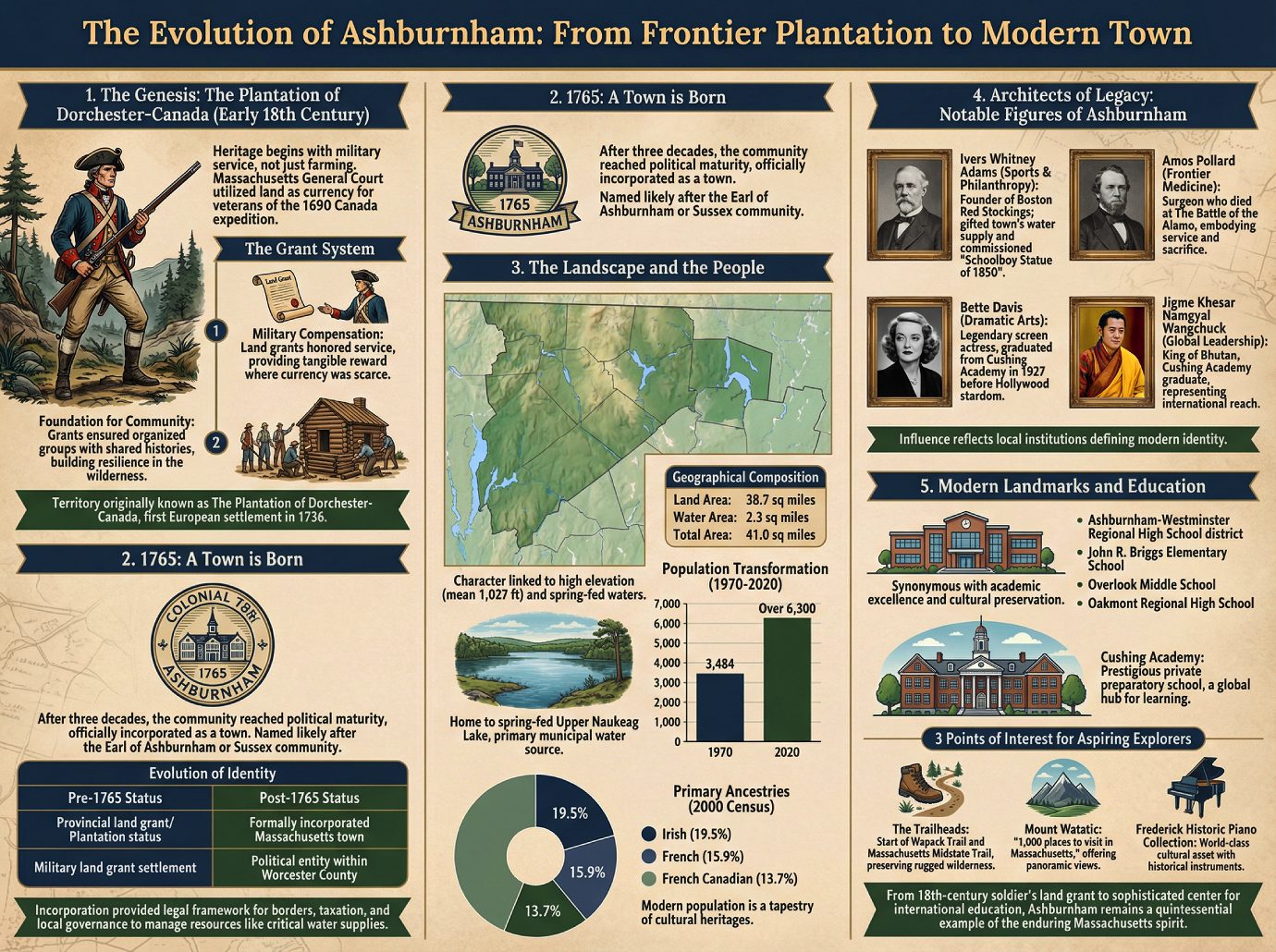
1. The Genesis: The Plantation of Dorchester-Canada
The heritage of Ashburnham does not begin with the quiet expansion of farmers, but rather with the rugged demands of military service. In the early 18th century, the Massachusetts General Court utilized land as a form of currency, providing grants to those who had faced the rigors of the frontier. The specific territory we now know as Ashburnham was set aside for the officers and soldiers—and their descendants—who had participated in the grueling 1690 expedition to Canada.
“The territory was originally known as The Plantation of Dorchester-Canada, with the first European settlement occurring in 1736.”
The Grant System
• Military Compensation: Land was the primary mechanism for the colonial government to honor the service of veterans from the 1690 Canada expedition, providing a tangible reward where liquid currency was scarce.
• Foundation for Community: The grant system ensured that the initial inhabitants arrived as organized groups with shared histories and social bonds, providing the necessary resilience to build a society within the New England wilderness.
This transition from a frontier outpost to a structured community necessitated a move beyond military oversight toward a formal civil identity.
2. 1765: A Town is Born
After nearly three decades of growth as a plantation, the community reached a milestone of political maturity. In 1765, the settlement was officially incorporated as a town. Reflecting the deep ties to the British Crown during that era, the name “Ashburnham” was selected, likely in honor of the Earl of Ashburnham (from Pembrey) or perhaps the Sussex community of Ashburnham.
Evolution of Identity
| Pre-1765 Status | Post-1765 Status |
|---|---|
| Provincial land grant/Plantation status | Formally incorporated Massachusetts town |
| Military land grant settlement | Political entity within Worcester County |
This act of incorporation was the vital “so what?” of the town’s early history; it provided the legal framework necessary to define permanent borders and establish the taxation and local governance required to manage the land’s abundant natural resources, such as the critical water supplies that would sustain future generations.
3. The Landscape and the People
Ashburnham’s character is inextricably linked to its elevation and the spring-fed waters of the Massachusetts highlands. Positioned at the northeastern corner of Worcester County, the town serves as a gateway to the New Hampshire border. The town is defined by a high mean elevation of 1,027 feet and a landscape where water plays a central role in both ecology and infrastructure.
Geographical Composition
| Feature | Measurement |
|---|---|
| Land Area | 38.7 square miles |
| Water Area | 2.3 square miles |
| Total Area | 41.0 square miles |
The town is home to the spring-fed Upper Naukeag Lake, which remains the primary municipal water source. While the town’s population remained relatively stable for two centuries, Ashburnham underwent a significant transformation beginning in the 1970s. The community expanded from 3,484 residents in 1970 to over 6,300 by 2020. This modern population is a tapestry of cultural heritages, with the 2000 census noting the following primary ancestries:
1. Irish (19.5%)
2. French (15.9%)
3. French Canadian (13.7%)
This unique environment and diverse social fabric have consistently produced individuals of national and international consequence.
4. Architects of Legacy: Notable Figures of Ashburnham
The history of Ashburnham is best viewed through the lives of those who have been shaped by its institutions. Far from being an isolated border town, Ashburnham has served as a crucible for leaders in sport, medicine, and global diplomacy.
| Name | Area of Influence | Legacy/So What? |
|---|---|---|
| Pioneers and Leaders | ||
| Ivers Whitney Adams | Sports & Philanthropy | Founder of the Boston Red Stockings; he secured the town’s future by gifting its water supply and commissioning the iconic “Schoolboy Statue of 1850.” |
| Amos Pollard | Frontier Medicine | A surgeon who died at The Battle of the Alamo, embodying the town’s long history of service and sacrifice on the frontier. |
| Arts and Culture | ||
| Bette Davis | Dramatic Arts | The legendary screen actress spent her formative years here, graduating from Cushing Academy in 1927 before ascending to Hollywood royalty. |
| Education | ||
| Jigme Khesar Namgyal Wangchuck | Global Leadership | As a graduate of Cushing Academy, the King of Bhutan represents the town’s profound international reach, proving that Ashburnham’s schools cultivate leaders who impact the world stage. |
The influence of these individuals is a direct reflection of the local institutions that continue to define the town’s modern identity.
5. Modern Landmarks and Education
In the contemporary era, Ashburnham is synonymous with academic excellence and the preservation of New England’s cultural treasures. The town is served by the Ashburnham-Westminster Regional High School district. Younger students begin their journey at the John R. Briggs Elementary School, eventually moving through Overlook Middle School and Oakmont Regional High School.
The crown jewel of the town’s educational landscape is Cushing Academy, a prestigious private preparatory school that serves as a global hub for learning. Beyond the classroom, Ashburnham offers a wealth of exploration for the historically and environmentally minded.
3 Points of Interest for Aspiring Explorers
1. The Trailheads: Ashburnham marks the start of both the Wapack Trail and the Massachusetts Midstate Trail, preserving the rugged wilderness that first greeted 18th-century settlers.
2. Mount Watatic: Officially recognized as one of the “1,000 places to visit in Massachusetts,” offering panoramic views of the region’s geography.
3. Frederick Historic Piano Collection: A world-class cultural asset that houses a significant collection of historical instruments, bridging the gap between past and present.
From its 18th-century origin as a soldier’s land grant to its current standing as a sophisticated center for international education, Ashburnham remains a quintessential example of the enduring Massachusetts spirit.
5 Surprising Secrets of Ashburnham, Massachusetts
More Than a Quiet New England Town: 5 Surprising Secrets of Ashburnham, Massachusetts
Introduction: The Hidden Heart of Worcester County
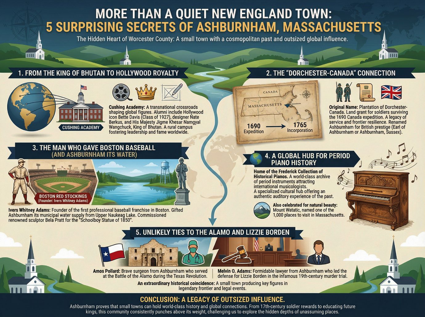
Ashburnham presents the quintessential New England facade—white steeples and rolling hills—that masks a surprisingly cosmopolitan past. While the town’s population hovers just over 6,300, its historical footprint stretches far beyond the borders of Worcester County. This is a community where local heritage intersects with global royalty and the birth of professional sports, proving that a town’s significance is rarely measured by its geographic size alone.
From the King of Bhutan to Hollywood Royalty
The town serves as a unique cultural incubator, largely due to the presence of Cushing Academy, a private preparatory school that functions as a transnational crossroads. For decades, this rural campus has quietly shaped figures who would go on to dominate both the silver screen and international diplomacy. It is a remarkable duality to find a single institution in the Massachusetts woods that fostered both an American cinematic titan and a reigning Himalayan monarch.
Legendary actress Bette Davis, a member of the class of 1927, walked these halls long before becoming an icon of Hollywood’s Golden Age. The school’s reach is truly global, counting among its alumni the designer Nate Berkus and His Majesty Jigme Khesar Namgyal Wangchuck, the King of Bhutan. These connections illustrate how a private school in a quiet New England town can serve as a conduit for leadership and fame on a worldwide scale.
The “Dorchester-Canada” Connection
Long before its 1765 incorporation, the area was known by the rugged name of the Plantation of Dorchester-Canada. This was no ordinary settlement; the land was a military grant awarded to the officers and soldiers who survived the 1690 expedition to Canada. This origin as a soldier’s reward imbues the town’s soil with a legacy of service and frontier resilience that predates the founding of the nation.
The eventual transition to the name “Ashburnham” reflected a pivot toward British prestige, though historians recognize two distinct possibilities for its namesake. The name was likely drawn from the Earl of Ashburnham in Pembrey or inspired by the historic community of Ashburnham in Sussex, England. This linguistic tie to the British Isles serves as a permanent reminder of the town’s colonial identity and its place within the wider Atlantic world.
The Man Who Gave Boston Baseball (and Ashburnham its Water)
Ivers Whitney Adams represents a fascinating intersection of urban industrialism and small-town philanthropy. As the founder and president of the Boston Red Stockings, Adams established the very first professional baseball franchise in Boston, forever changing the American sporting landscape. Yet, while he was architecting the future of professional sports in the city, his heart remained tethered to the infrastructure and aesthetics of his hometown.
Adams demonstrated a profound commitment to Ashburnham by gifting the town its municipal water supply, sourced from the pristine, spring-fed Upper Naukeag Lake. He also sought to elevate the town’s cultural profile by commissioning the renowned sculptor Bela Pratt to design the “Schoolboy Statue of 1850.” That a work by such a world-caliber artist sits on a quiet street corner at Main and School streets is a testament to Adams’ desire to bring high-caliber art to his rural roots.
A Global Hub for Period Piano History
Ashburnham has earned an international reputation among musicologists as the home of the Frederick Collection of Historical Pianos. This world-class archive of period instruments transforms the town into a specialized cultural hub, attracting visitors who seek an authentic auditory experience of the past. The rarity of this collection mirrors the rarity of the town’s natural preservation efforts, creating a landscape that is as intellectually stimulating as it is beautiful.
The town’s commitment to preserving these treasures, both artistic and environmental, has been recognized by state commissions as a vital part of the Massachusetts experience. This synergy between cultural history and natural beauty is best reflected in the town’s celebrated geography:
Mount Watatic was named as one of the 1,000 places to visit in Massachusetts by the Great Places in Massachusetts Commission.
Unlikely Ties to the Alamo and Lizzie Borden
Perhaps the most striking statistical anomaly in Ashburnham’s history is its connection to some of the most sensational events in North American lore. The town was the home of Amos Pollard, the brave surgeon who served at the Battle of the Alamo during the height of the Texas Revolution. It is a staggering thought that a doctor from the quiet woods of Worcester County was present at one of the most famous sieges in military history.
The town’s penchant for the dramatic continued with the birth of Melvin O. Adams, the formidable lawyer who led the defense for Lizzie Borden in the 19th century’s most infamous murder trial. To have a single small community produce both a primary actor in a legendary frontier battle and the legal mind behind a “trial of the century” is an extraordinary historical coincidence. These links suggest that Ashburnham’s residents have a peculiar habit of finding themselves at the center of the continent’s most pivotal moments.
Conclusion: A Legacy of Outsized Influence
Ashburnham stands as a compelling reminder that the “quiet” towns of New England are often repositories of world-class history and global connections. From its origins as a reward for 17th-century soldiers to its role as an educational crossroads for future kings, this town consistently punches above its weight class. It challenges us to look more closely at the map and wonder what other hidden depths lie beneath the surface of our most unassuming communities. By preserving these local narratives, we gain a much clearer window into the grand, interconnected tapestry of our shared global heritage.
———————–
Community Profile: Ashburnham, Massachusetts
Community Profile: Ashburnham, Massachusetts
1.0 Introduction: An Overview of Ashburnham
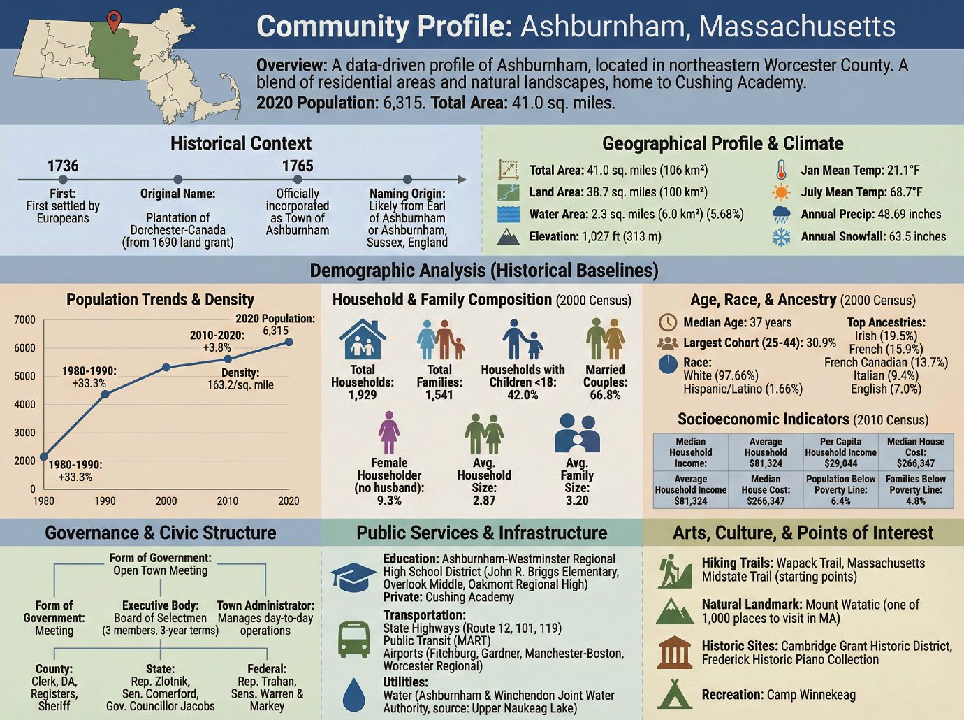
This document provides a comprehensive, data-driven overview of the Town of Ashburnham, Massachusetts. Drawing upon a range of public data, this profile covers the town’s history, geography, demographics, governance, and infrastructure. It is intended to serve as a foundational document for government and community stakeholders engaged in planning, policy development, and community assessment.
Located in the northeastern corner of Worcester County, Ashburnham is a town with a 2020 population of 6,315. Encompassing a total area of 41.0 square miles, the community is a blend of residential areas and natural landscapes, and is notably home to the private preparatory school, Cushing Academy. This profile begins by exploring the historical roots that have shaped the town’s present-day character.
2.0 Historical and Geographical Context
2.1 Foundational History
Understanding a municipality’s foundational history is essential for contextualizing its current character, land use patterns, and civic identity. Ashburnham’s origins are tied to the colonial expansion of New England in the 18th century.
The key milestones in the town’s establishment are as follows:
• 1736: The area was first settled by Europeans.
• Original Name: Ashburnham was initially known as the “Plantation of Dorchester-Canada,” a name originating from a 1690 land grant to officers and soldiers who had participated in an expedition to Canada.
• 1765: The plantation was officially incorporated as the Town of Ashburnham.
• Naming Origin: The town’s name is of British origin and is likely derived either from the Earl of Ashburnham or the community of Ashburnham in Sussex, England.
2.2 Geographical Profile and Climate
Ashburnham’s physical environment is defined by its location in the northeastern corner of Worcester County and its significant water resources. According to the United States Census Bureau, the town’s key geographical statistics are:
• Total Area: 41.0 square miles (106 km²)
• Land Area: 38.7 square miles (100 km²)
• Water Area: 2.3 square miles (6.0 km²), constituting 5.68% of the total area
• Elevation: 1,027 feet (313 m)
The climate in Ashburnham is characterized by distinct seasonal variations, with warm summers and cold, snowy winters. Data from the National Oceanic and Atmospheric Administration (NOAA) for Ashburnham North shows a daily mean temperature in January of 21.1°F, contrasting with a July daily mean of 68.7°F. The town receives an average of 48.69 inches of precipitation annually, including an average annual snowfall of 63.5 inches.
This physical setting provides the backdrop for the community’s demographic composition and development.
3.0 Demographic Analysis
A thorough demographic analysis is critical for understanding the town’s social fabric, workforce potential, and demand for public services. The following data presents a snapshot of Ashburnham’s population characteristics. It is important to note that while population totals are from the 2020 Census, the detailed household, racial, and socioeconomic data is drawn from the 2000 and 2010 U.S. Censuses, as this is the most recent granular data available in the source document. These older figures should be used as a historical baseline and may not reflect the town’s current composition.
3.1 Population Trends and Density
An examination of historical census data reveals a pattern of steady, and at times rapid, growth. The most significant period of expansion occurred between 1980 and 1990, when the population increased by 33.3%. More recently, from 2010 to 2020, the town grew by 3.8%. As of the 2020 Census, Ashburnham’s population was 6,315, resulting in a population density of 163.2 inhabitants per square mile.
3.2 Household and Family Composition (2000 Census)
The 2000 U.S. Census provides detailed insight into the structure of households within the community. As this data is over two decades old, it serves as a historical reference point. Key findings from that period include:
• Total Households: 1,929
• Total Families: 1,541
• Households with Children Under 18: 42.0%
• Married Couples Living Together: 66.8%
• Female Householder (no husband): 9.3%
• Average Household Size: 2.87
• Average Family Size: 3.20
3.3 Age, Race, and Ancestry (2000 Census)
The following data from the 2000 U.S. Census provides a historical baseline for Ashburnham’s demographic composition. According to that census, the median age in Ashburnham was 37 years. The largest age cohort was residents between 25 and 44 years old, who comprised 30.9% of the population.
The racial and ethnic composition of the town in 2000 was predominantly White (97.66%), with individuals identifying as Hispanic or Latino of any race making up 1.66% of the population. The top five reported ancestries at that time were Irish (19.5%), French (15.9%), French Canadian (13.7%), Italian (9.4%), and English (7.0%).
3.4 Socioeconomic Indicators (2010 Census)
Data from the 2010 U.S. Census offers a historical view of the town’s economic landscape. These figures may not represent current conditions. Key indicators from this census are summarized below.
| Indicator | Value |
|---|---|
| Median Household Income | $76,250 |
| Average Household Income | $81,324 |
| Per Capita Household Income | $29,044 |
| Median House Cost | $266,347 |
| Population Below Poverty Line | 6.4% |
| Families Below Poverty Line | 4.8% |
This demographic and socioeconomic profile informs the needs and responsibilities of the town’s governing structure.
4.0 Governance and Civic Structure
Understanding a municipality’s governance framework is fundamental, as it dictates policy-making, public administration, and civic engagement. Ashburnham operates under an Open Town Meeting form of government, a system that allows registered voters to participate directly in legislative decisions.
The town’s primary executive body is the Board of Selectmen, whose members are elected to three-year terms. As of a January 2020 update, the Board was composed of a chair and two members. Day-to-day municipal operations are managed by a Town Administrator (Brian Doheny, as of the source’s last update).
Ashburnham is represented at the county, state, and federal levels by the following elected officials:
• County Government (Worcester County)
◦ Clerk of Courts: Dennis P. McManus
◦ District Attorney: Joseph D. Early, Jr. (D)
◦ Register of Deeds: Kathleen R. Daigneault (D)
◦ Register of Probate: Stephen Abraham (D)
◦ County Sheriff: Lew Evangelidis (R)
• State Government
◦ State Representative: Jonathan Zlotnik (D-2nd Worcester)
◦ State Senator: Jo Comerford (D-Hampshire, Franklin, & Worcester)
◦ Governor’s Councillor: Tara Jacobs (D-Eighth Councillor District)
• Federal Government
◦ U.S. Representative: Lori Trahan (D-3rd District)
◦ U.S. Senators: Elizabeth Warren (D), Ed Markey (D)
This governing body oversees the essential public services and infrastructure that support the community.
5.0 Public Services and Infrastructure
Infrastructure and public services form the essential backbone of a community, directly impacting resident quality of life, economic activity, and future development. Ashburnham provides core services in education, transportation, and utilities.
5.1 Education System
Public education in Ashburnham is administered as part of the Ashburnham-Westminster Regional High School district, which it shares with the neighboring town of Westminster. The public schools serving the town’s students are:
• John R. Briggs Elementary School (Grades K–5)
• Overlook Middle School
• Oakmont Regional High School
In addition to its public schools, Ashburnham is home to Cushing Academy, a prominent private preparatory school.
5.2 Transportation Network
The town is connected to the regional transportation network by several state highways, including Route 12, Route 101, and Route 119.
Public transit is available through the Montachusett Regional Transit Authority (MART), which provides fixed-route bus services, shuttle services, and para-transit services for Ashburnham and the surrounding region. For air travel, general aviation services are available at Fitchburg Municipal Airport and Gardner Municipal Airport. The nearest airports with national service are Manchester-Boston Regional Airport in New Hampshire and Worcester Regional Airport.
5.3 Utilities
Municipal water is supplied by the Ashburnham & Winchendon Joint Water Authority. The authority draws its water from the spring-fed Upper Naukeag Lake, located within Ashburnham.
Beyond foundational infrastructure, the town offers a range of cultural and recreational amenities that contribute to its community life.
6.0 Arts, Culture, and Points of Interest
Cultural assets and recreational opportunities are key indicators of a community’s quality of life and attractiveness to residents and visitors. Ashburnham offers several notable natural and historical points of interest.
• Wapack Trail and Massachusetts Midstate Trail: Ashburnham serves as the starting point for these two significant long-distance hiking trails.
• Mount Watatic: This local mountain has been recognized by the Great Places in Massachusetts Commission as one of the 1,000 places to visit in the state.
• Cambridge Grant Historic District: A designated historic area within the town.
• Frederick Historic Piano Collection: A notable collection of historical pianos.
• Camp Winnekeag: A local camp facility.
In summary, this profile presents Ashburnham as a town with deep historical roots, a stable and growing population, and a governance structure focused on providing essential services. Its location, natural assets, and blend of public and private educational institutions define its unique character within Worcester County.