


Petersham MA – Community Profile and History
The History and a Complete Community Profile on Petersham, Massachusetts.
Community Profile: Petersham Massachusetts
Tiny Massachusetts Town with the Shockingly Big Story
Petersham MA – Small Town with a Big Heart
Historical Brief of Petersham MA
Key Facts – Petersham Massachusetts
Listen to a “Deep Dive” on any device, CLICK PLAY.
Community Profile: Petersham, Massachusetts
Community Profile: Petersham, Massachusetts
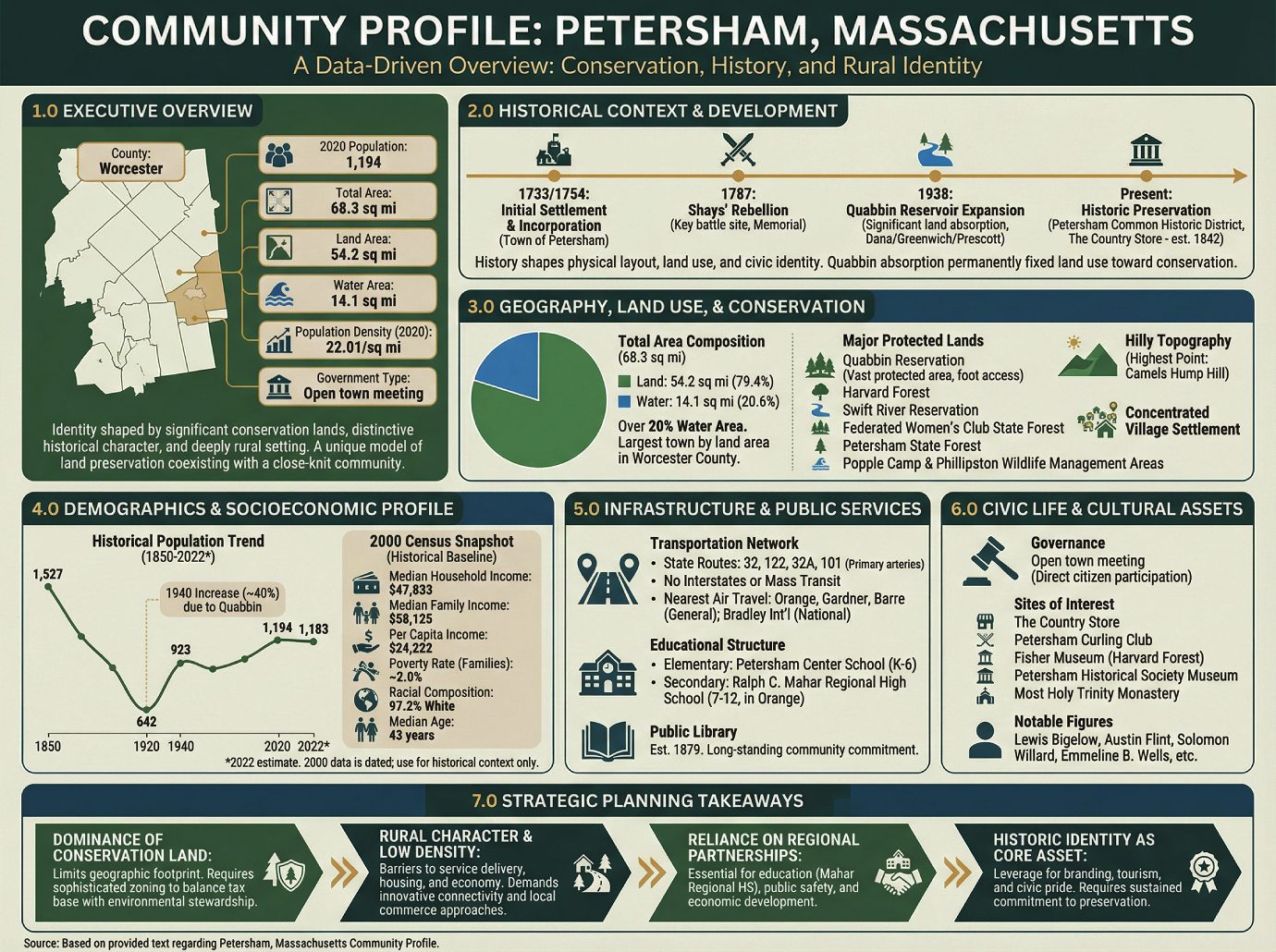
1.0 Executive Overview
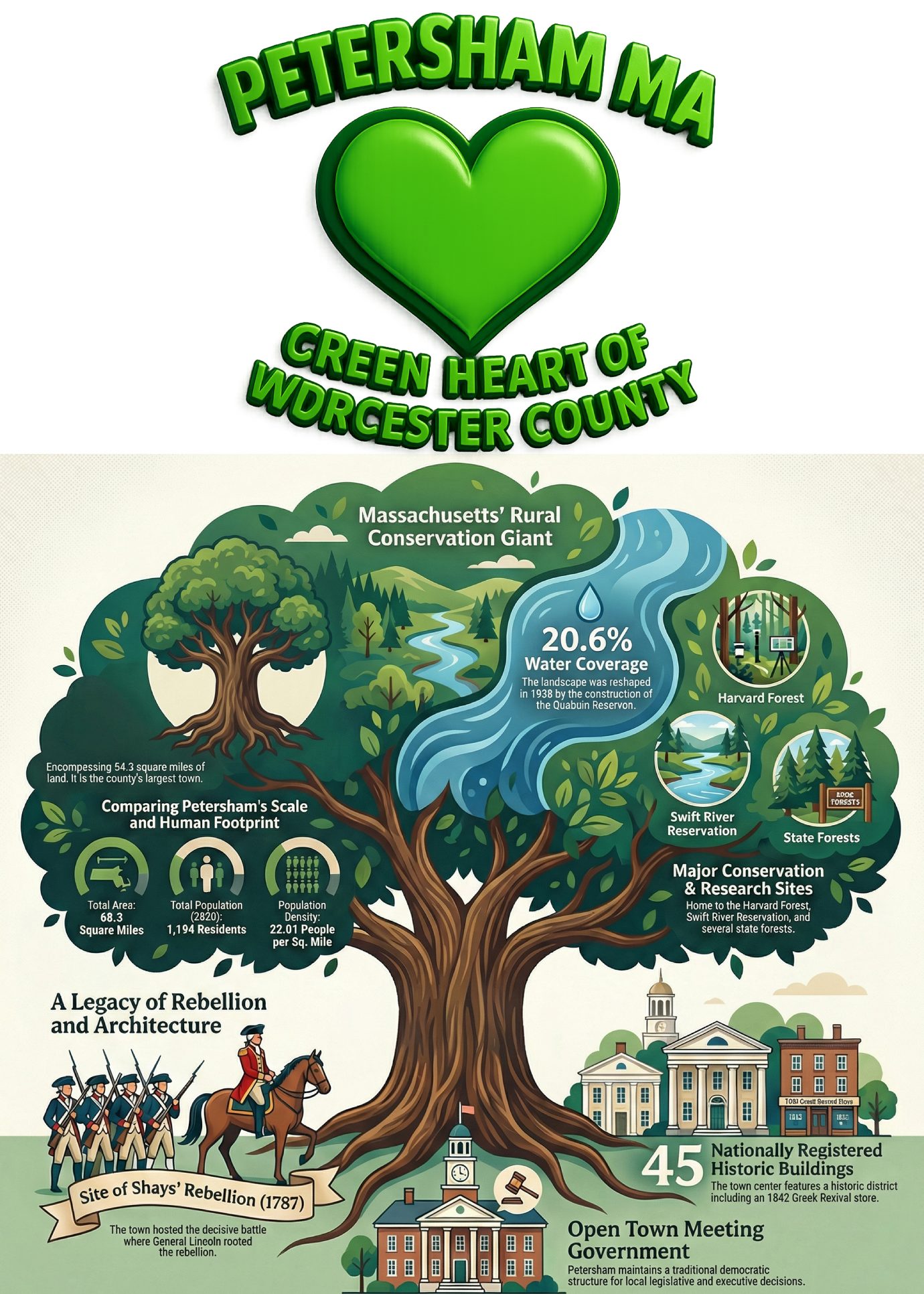
Petersham is a town in Worcester County, Massachusetts, whose identity is fundamentally shaped by its significant conservation lands, distinctive historical character, and deeply rural setting. With a vast portion of its territory protected as part of the Quabbin Reservation and various state forests, the town offers a unique model of land preservation coexisting with a small, close-knit community. This profile provides a data-driven overview of Petersham’s historical, geographical, demographic, and civic foundations to support informed municipal planning and strategic decision-making.
| Attribute | Data |
|---|---|
| County | Worcester |
| 2020 Population | 1,194 |
| Total Area | 68.3 sq mi |
| Land Area | 54.2 sq mi |
| Water Area | 14.1 sq mi |
| Population Density (2020) | 22.01/sq mi |
| Government Type | Open town meeting |
The town’s present-day characteristics are deeply rooted in key events and decisions from its past, making an understanding of its history essential to planning for its future.
2.0 Historical Context and Development
Understanding a community’s historical trajectory is critical for effective modern planning, as past events directly influence its physical layout, land use patterns, and civic identity. In Petersham, pivotal moments—from its role in a national rebellion to its major territorial expansion in the 20th century—have permanently shaped the town’s boundaries and character, creating the foundation upon which all future development must be considered.
Key historical milestones for Petersham include:
• Initial Settlement and Incorporation: The area was first settled by Europeans in 1733 and was officially incorporated as the Town of Petersham on April 20, 1754.
• Shays’ Rebellion: On February 4, 1787, Petersham was the site of a key battle in Shays’ Rebellion. A memorial erected in 1927 commemorates the actions of General Benjamin Lincoln, who routed the rebellion, and is inscribed with the maxim: “Obedience to the law is true liberty.”
• Territorial Expansion: The town’s land area expanded significantly in 1938 with the construction of the Quabbin Reservoir. Following the disincorporation of several towns in the Swift River Valley, Petersham absorbed all of the former town of Dana, a large portion of Greenwich, and a small part of Prescott.
• Historic Preservation: The town center is distinguished by the Petersham Common Historic District, which includes approximately 45 buildings listed on the National Register of Historic Places. A prominent landmark is The Country Store, a Greek Revival structure built in 1842 that has operated as a general store since its opening.
The 20th-century absorption of lands for the Quabbin Reservoir was a decisive event, permanently fixing the town’s land use trajectory toward conservation and shaping all subsequent development constraints.
3.0 Geography, Land Use, and Conservation
Petersham’s geography is its most defining characteristic and the primary influence on its community character and development potential. The town is dominated by vast tracts of protected land and water, a reality that dictates land use, limits large-scale development, and solidifies its role as a steward of significant regional environmental resources.
The town’s geographic composition is notable. With a total area of 68.3 square miles, it is comprised of 54.2 square miles of land and 14.1 square miles of water, meaning over 20% (20.60%) of its total area is water. This scale makes Petersham the largest town by land area in Worcester County and the fifth-largest municipality in Massachusetts.
A substantial portion of this land is permanently protected within state and private conservation areas, including:
• Quabbin Reservation: A vast protected area surrounding the reservoir. The lands are accessible only on foot and include the former Dana Common, a unique historical and recreational site accessible via a 1.5-mile walk from Gate 40.
• Harvard Forest
• Swift River Reservation
• Federated Women’s Club State Forest
• Petersham State Forest
• Popple Camp Wildlife Management Area
• Phillipston Wildlife Management Area
The town’s topography is hilly, with its highest point being Camels Hump Hill. Settlement is not evenly distributed; the population is primarily concentrated in the rural village of Petersham, situated near the historic town common. This combination of vast protected lands and a concentrated village settlement reinforces the town’s profoundly rural character.
The town’s rural geography and dispersed settlement pattern are directly reflected in its demographic profile.
4.0 Demographics and Socioeconomic Profile
Demographic and socioeconomic data provide a fundamental baseline for planning public services, housing, and strategies for economic sustainability. An analysis of Petersham’s population trends and composition reveals a community that has experienced periods of decline and slow recovery, maintaining a small, stable population with distinct socioeconomic characteristics.
Historical Population Data
| Year | Population |
|---|---|
| 1850 | 1,527 |
| 1860 | 1,465 |
| 1870 | 1,335 |
| 1880 | 1,109 |
| 1890 | 1,050 |
| 1900 | 853 |
| 1910 | 757 |
| 1920 | 642 |
| 1930 | 660 |
| 1940 | 923 |
| 1950 | 814 |
| 1960 | 890 |
| 1970 | 1,014 |
| 1980 | 1,024 |
| 1990 | 1,131 |
| 2000 | 1,180 |
| 2010 | 1,234 |
| 2020 | 1,194 |
| 2022* | 1,183 |
| <small>*= population estimate.</small> |
The historical data reveals a significant population decline from the mid-19th century through 1920. A notable increase of nearly 40% occurred in 1940, coinciding with the Quabbin Reservoir’s creation and the absorption of land from former towns. Since then, the population has slowly recovered but remains below its 19th-century peak.
A snapshot from the 2000 U.S. Census provides key socioeconomic indicators:
• Household & Family Income: The median household income was $47,833, and the median family income was $58,125.
• Per Capita Income: The per capita income for the town was $24,222.
• Poverty Rate: Approximately 2.0% of families and 5.8% of the total population were living below the poverty line.
• Racial Composition: The town’s population was predominantly White (97.20%).
• Age Distribution: The population was spread across age groups, with 22.4% under 18, 27.0% from 25 to 44, 28.7% from 45 to 64, and 17.5% aged 65 or older. The median age was 43 years.
It is critical to note that this detailed socioeconomic data is from the 2000 Census. As it is over two decades old, it must be used only as a historical baseline and not for current planning; more recent American Community Survey (ACS) data would be required for any substantive analysis.
This demographic profile—characterized by a static population and a significant senior cohort—places specific demands on the town’s service infrastructure, particularly regarding healthcare access, senior services, and the need to attract younger families to ensure long-term vitality.
5.0 Infrastructure and Public Services
The quality and availability of infrastructure and public services are critical for supporting community life, ensuring public safety, and enabling economic activity. Petersham’s infrastructure reflects its rural nature, characterized by a reliance on regional networks for transportation and education while maintaining core local services.
Transportation Network
The town is served by several state routes that converge near the town center, including Routes 32, 122, 32A, and 101. These highways are the primary arteries for travel to and from neighboring communities. Notably, there are no interstates or other limited-access highways within the town’s borders. Mass transit is completely absent in Petersham. The nearest transportation hubs for private and commercial air travel are:
• General Aviation: Orange Municipal Airport, Gardner Municipal Airport, and Tanner-Hiller Airport in Barre.
• National Air Service: Bradley International Airport in Connecticut.
Educational Structure
Petersham’s public education system is structured through a combination of local and regional partnerships:
• Elementary: The Petersham Center School serves students in kindergarten through sixth grade.
• Secondary: High school students attend the Ralph C. Mahar Regional High School, located in the neighboring town of Orange.
Public Library Services
The Petersham public library was established in 1879. In fiscal year 2008, the town allocated 0.35% of its budget, or $10,752, to the library. This funding equated to approximately $8 per person per year, demonstrating a long-standing community commitment to this public resource (note: this data is significantly dated and reflects pre-recession funding levels).
The town’s formal services are complemented by a range of civic and cultural assets that define its community life.
6.0 Civic Life and Cultural Assets
A community’s character is defined not only by its formal services but also by its civic structure, cultural institutions, and points of interest. Petersham’s governance is rooted in direct citizen participation, and its cultural landscape reflects its history, natural resources, and the contributions of its notable residents.
Governance
The town operates under an Open town meeting form of government. Representation at the state and federal levels is as follows:
| Office | Representative(s) |
|---|---|
| State Representative | Susannah Whipps Lee (R) |
| State Senator | Anne Gobi (D) |
| Governor’s Councilor | Paul Depalo (D) |
| U.S. Representative | James P. McGovern (D-2nd District) |
| U.S. Senators | Elizabeth Warren (D), Ed Markey (D) |
Sites of Interest
Primary sites of interest that serve as community hubs and attractions include:
• The Country Store
• Petersham Curling Club
• Fisher Museum, Harvard Forest
• Petersham Historical Society Museum
• Most Holy Trinity Monastery
Notable Figures
Several individuals of historical and cultural significance have been associated with the town, including:
• Lewis Bigelow, congressman
• Yodelin’ Slim Clark, musician
• Dorothy Eaton, painter
• Austin Flint, physician
• James Hawkes, congressman
• Jonas Howe, Massachusetts state legislator
• Emmeline B. Wells, journalist, activist
• Solomon Willard, builder of Bunker Hill Monument
Taken together, these civic and cultural elements underscore the town’s unique identity and provide a framework for future planning initiatives.
7.0 Conclusion: Synthesis for Strategic Planning
This profile of Petersham, Massachusetts, illustrates a town defined by the enduring interplay between its historical legacy and its vast natural landscape. With a small, stable population and a governance model rooted in direct participation, the town’s future planning efforts must navigate a unique set of constraints and opportunities. The data reveals a community deeply committed to preserving its rural character, historic identity, and significant conservation lands.
For strategic planning purposes, the following key takeaways emerge from this analysis:
1. Dominance of Conservation Land: With a majority of its land area permanently protected, Petersham’s planning is constrained to a limited geographic footprint. This necessitates sophisticated zoning and land use policies that balance the town’s limited tax base growth with its non-negotiable role as an environmental steward.
2. Rural Character and Low Density: The town’s low density and lack of public transit create structural barriers to service delivery, housing diversification, and economic development, demanding innovative, non-traditional approaches to connectivity and local commerce.
3. Reliance on Regional Partnerships: Petersham is intrinsically linked to its neighbors for essential services, most notably secondary education through the Ralph C. Mahar Regional High School. This reliance underscores the importance of maintaining and strengthening regional collaborations for education, public safety, and economic development to ensure the long-term well-being of its residents.
4. Historic Identity as a Core Asset: The town’s rich history, physically embodied in the Petersham Common Historic District and its numerous preserved buildings, is a significant cultural and economic asset. This identity can be leveraged for community branding, heritage tourism, and fostering civic pride. However, it also requires a sustained commitment to historic preservation standards and investment in maintaining these irreplaceable community assets.
——————-
The Tiny Massachusetts Town with a Shockingly Big Story
The Tiny Massachusetts Town with a Shockingly Big Story
Introduction: The Quiet Towns with the Loudest Histories
Picture a small New England town. You likely imagine a peaceful village common, a general store, and a sense of quiet history stretching back centuries. Petersham, Massachusetts, fits this image perfectly, with a population of just around 1,200 people. It is the very picture of rural tranquility.
But beneath this quiet exterior lies a series of paradoxes. This is a place where the map was redrawn by a man-made flood, where vast emptiness defies its geographic scale, and where the most prominent memorial celebrates not revolution, but its decisive suppression. The story of Petersham is a surprising lesson in how a seemingly sleepy town can hold some of a region’s most complex and turbulent truths.
——————————————————————————–
1. It Grew by Drowning Its Neighbors
In a geographic twist that defies logic, Petersham’s modern identity was forged in 1938 not by settlement, but by subtraction. As the Quabbin Reservoir’s waters rose to swallow the Swift River Valley, Petersham didn’t shrink—it anomalously grew. The creation of the reservoir required the complete disincorporation and flooding of four neighboring towns.
As a result, Petersham’s territory expanded to absorb all of the former town of Dana, much of Greenwich, and a portion of Prescott. The erasure was so complete that today, the only publicly accessible remnant of the lost towns is the former site of Dana Common, a ghost of a town center reachable only by a long walk into the reservation—a place where history must be sought out on foot. It is a strange and somber legacy for a town to grow by inheriting the lands of its neighbors, who were deliberately erased from the map.
2. It’s One of the Biggest Towns in Massachusetts, With Almost No One In It
Here is the central paradox of Petersham: it is the largest town by land area in Worcester County and the fifth-largest in all of Massachusetts, yet it is nearly empty. The town’s total area is a sprawling 68.3 square miles, but with over 14 square miles of that now underwater, its actual land area is 54.2 square miles. This land is home to a mere 1,194 people (as of 2020), resulting in a stark population density of just 22 people per square mile.
This unique size-to-population ratio defines the town’s character. This is not a landscape of suburbs and cul-de-sacs, but a territory ruled by the quiet dominion of protected forests and the vast, silent expanse of the Quabbin Reservation, where nature has reclaimed history.
3. Its Most Famous Memorial Celebrates Crushing a Rebellion
Petersham was the site of a pivotal event in early American history: the final, decisive confrontation of Shays’ Rebellion. On February 4, 1787, a populist uprising of struggling farmers was effectively ended here. However, the memorial erected on the town common in 1927 doesn’t celebrate the rebels; it commemorates General Benjamin Lincoln, the man who suppressed them with a force of 3,000 troops.
The monument’s final, stark line is a powerful statement of the victor’s perspective, celebrating state power over popular dissent.
Obedience to the law is true liberty.
This message is profoundly thought-provoking. In a nation born from rebellion, this monument offers an arresting counter-narrative. It stands as a cold, granite reminder that history is not just about the revolutions that succeed, but also about the ones that are crushed, and that “liberty” can be defined in dramatically different ways.
——————————————————————————–
Conclusion: A Landscape of Paradox
Petersham’s quiet landscape is a testament to the enduring power of the state. The drowned history of the Quabbin Reservoir and the stark political monument on the common are not separate stories; they are two expressions of the same force that shaped both the town’s geography and its official memory. The immense, empty, state-controlled wilderness is the quiet evidence of this power, a territory defined first by the victory over popular dissent, and later by the victory over the land itself.
How many other quiet places on the map are defined by such turbulent and fascinating histories?
——————
Welcome to Petersham, Massachusetts: A Small Town with a Big Heart (and Backyard!)
Welcome to Petersham, Massachusetts: A Small Town with a Big Heart (and Backyard!)
Introduction: Your Guide to Petersham
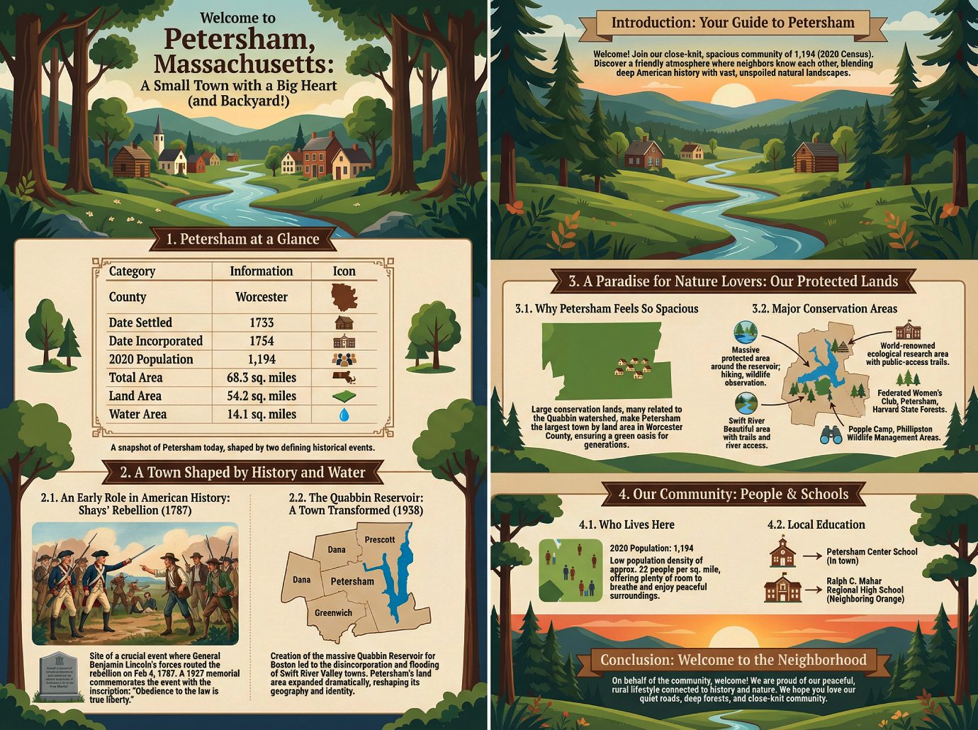
Welcome to Petersham! As a new resident, student, or visitor, you’re joining a community that is both close-knit and spacious. With a population of just 1,194 people as of the 2020 census, our town offers a friendly, personal atmosphere where neighbors know one another. We’re delighted to have you here and hope this guide provides a helpful introduction to our unique home.
What makes Petersham so special is its remarkable blend of deep American history and vast, unspoiled natural landscapes. From a pivotal role in the nation’s early years to the profound transformation that created the Quabbin Reservoir, our town’s story is written on its land. Today, Petersham is defined by its serene rural character and its incredible access to thousands of acres of beautiful, protected conservation land.
——————————————————————————–
1. Petersham at a Glance
Here are some quick facts to help you get acquainted with our town’s basic geography and vital statistics.
| Category | Information |
|---|---|
| County | Worcester |
| Date Settled | 1733 |
| Date Incorporated | 1754 |
| 2020 Population | 1,194 |
| Total Area | 68.3 square miles |
| Land Area | 54.2 square miles |
| Water Area | 14.1 square miles |
These numbers provide a snapshot of Petersham today, but the story of how our town came to be so large in area yet so small in population is rooted in two defining historical events.
2. A Town Shaped by History and Water
Petersham’s character has been forged by key moments in both early American history and the 20th century.
2.1. An Early Role in American History
Petersham was the site of a crucial event during Shays’ Rebellion, an uprising of farmers in post-Revolutionary War America. On February 4, 1787, General Benjamin Lincoln’s forces routed the rebellion here. A memorial was erected in 1927 to commemorate the event and the restoration of order, bearing the powerful inscription: “Obedience to the law is true liberty.”
2.2. The Quabbin Reservoir: A Town Transformed
The single most significant event in our modern history was the creation of the Quabbin Reservoir in 1938. To create this massive water source for Boston, the towns of the Swift River Valley were disincorporated and flooded. Petersham’s land area expanded dramatically by absorbing all of the former town of Dana, much of the town of Greenwich, and a small portion of the former town of Prescott, fundamentally reshaping our geography and identity. This event explains the unique combination of our small population and vast territory.
The creation of the reservoir and its protected watershed set the stage for Petersham’s current identity as a major center for conservation and outdoor recreation.
3. A Paradise for Nature Lovers: Our Protected Lands
The primary reason for Petersham’s quiet, rural atmosphere is the sheer amount of undeveloped land within its borders.
3.1. Why Petersham Feels So Spacious
A considerable amount of Petersham’s land is protected conservation land, much of it related to the Quabbin Reservoir watershed. Because of the territory it gained during the reservoir’s construction, Petersham is the largest town by land area in Worcester County. This protected status ensures that our town will remain a green oasis for generations to come.
3.2. Major Conservation Areas
Our town is home to an incredible collection of state forests, university research lands, wildlife management areas, and reservations, making it a true haven for nature lovers. Residents and visitors have access to a stunning array of natural resources, including:
• The Quabbin Reservation: A massive protected area surrounding the Quabbin Reservoir, offering incredible opportunities for hiking and wildlife observation.
• Harvard Forest: A world-renowned ecological research area and forest owned by Harvard University, with public-access trails.
• The Swift River Reservation: Another beautiful area offering trails and access to the river.
• Federated Women’s Club State Forest
• Petersham State Forest
• Harvard State Forest
• Popple Camp Wildlife Management Area
• Phillipston Wildlife Management Area
As you explore our natural landscape, you’ll also find a welcoming community and the essential services that make Petersham a wonderful place to live.
4. Our Community: People & Schools
Petersham is home to a small but vibrant community of residents who value the town’s quiet and cooperative spirit.
4.1. Who Lives Here
Our 2020 population was 1,194, which gives us a very low population density of approximately 22 people per square mile. This statistic truly captures the town’s rural and spacious character, offering residents plenty of room to breathe and enjoy the peaceful surroundings.
4.2. Local Education
The town provides a quality education for its younger residents through a two-part public school system.
• Grades K-6: Students attend the Petersham Center School, conveniently located right here in town.
• High School: For their secondary education, students attend Ralph C. Mahar Regional High School, which is located in the neighboring town of Orange.
——————————————————————————–
Conclusion: Welcome to the Neighborhood
On behalf of the entire community, welcome to Petersham. We are proud of our town’s unique ability to offer a peaceful, rural lifestyle that is deeply connected to both our nation’s history and the preservation of the natural world. We hope you will come to love its quiet roads, deep forests, and close-knit community as much as we do.
—————
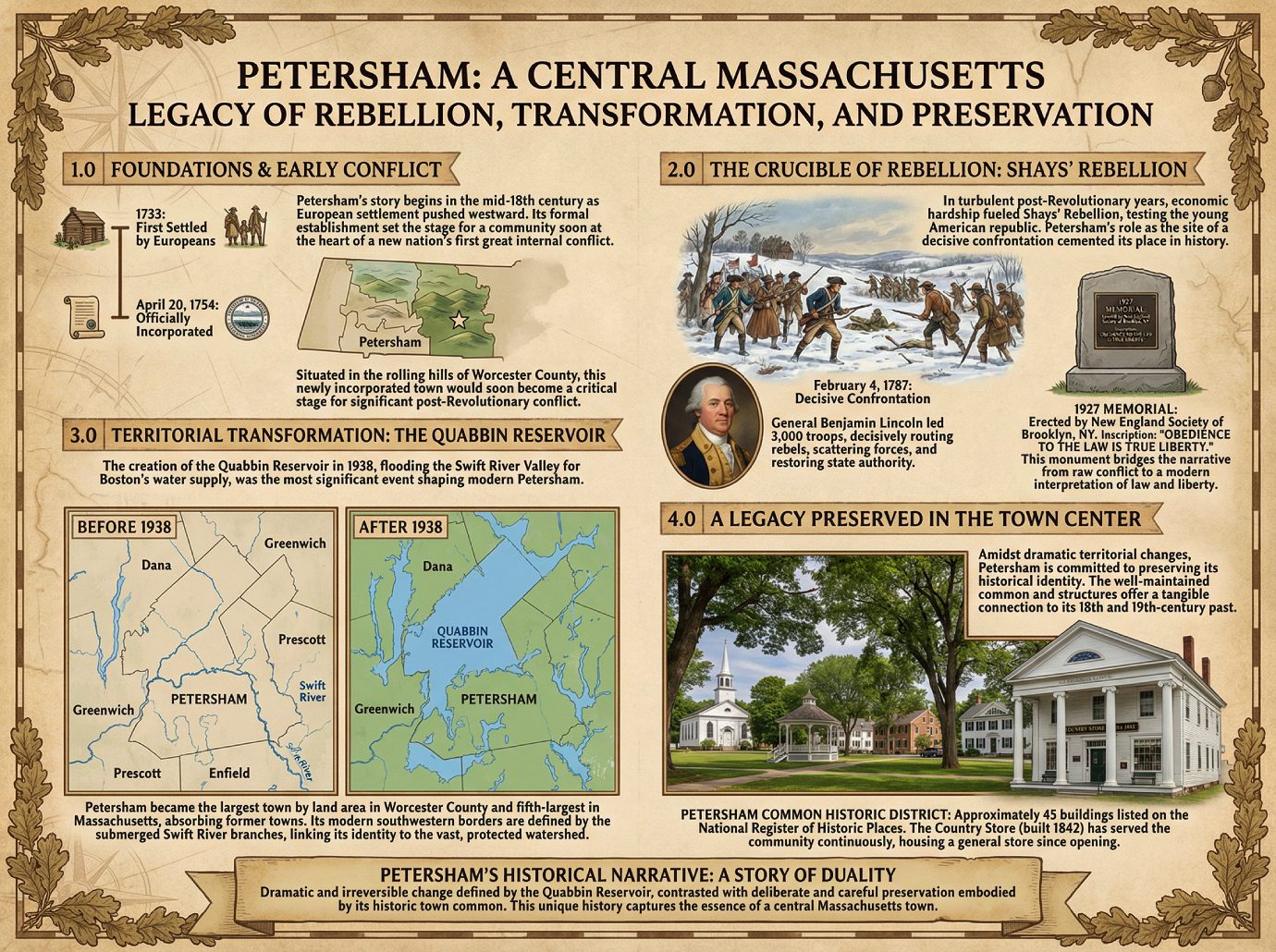
A Historical Brief of Petersham, Massachusetts
A Historical Brief of Petersham, Massachusetts
Petersham’s story, like that of many central Massachusetts towns, begins in the mid-18th century as European settlement pushed westward. Yet, its formal establishment provides more than a simple timeline; it sets the stage for a community that would soon find itself at the heart of a new nation’s first great internal conflict.
The key milestones in Petersham’s official establishment are as follows:
• First Settled by Europeans: 1733
• Officially Incorporated: April 20, 1754
This newly incorporated town, situated in the rolling hills of Worcester County, would soon become a critical stage for one of the most significant conflicts in the aftermath of the American Revolution.
2.0 The Crucible of Rebellion: Petersham’s Role in Shays’ Rebellion
In the turbulent years following the Revolutionary War, economic hardship and aggressive debt collection policies fueled widespread unrest among farmers in western and central Massachusetts. This conflict, known as Shays’ Rebellion, tested the resolve of the young American republic. Petersham’s role as the site of a decisive confrontation on February 4, 1787, cemented its place in the annals of early American history, transforming its quiet landscape into a key battleground of the insurrection.
On that winter day, General Benjamin Lincoln, leading a force of 3,000 troops, marched on Petersham and decisively routed the rebels who had gathered there. This action was a critical blow to the rebellion, effectively scattering its forces and helping to restore the authority of the state government.
More than a century later, in 1927, the New England Society of Brooklyn, New York, sponsored the erection of a memorial to commemorate General Benjamin Lincoln’s decisive action. The monument stands not only as a marker of the event but as a testament to a 20th-century interpretation of it, bearing an inscription that captures the philosophical sentiment of its era: “Obedience to the law is true liberty.”
The legacy of this event, framed by the 20th-century memorial, highlights a persistent tension between protest and authority. The memorial’s inscription bridges the narrative from the raw conflict of the 1780s to a modern interpretation of law and liberty, demonstrating how historical memory is shaped and preserved.
3.0 Territorial Transformation: The Impact of the Quabbin Reservoir
While Shays’ Rebellion defined Petersham’s early identity, the single most significant event to shape its modern geography was the creation of the Quabbin Reservoir. This monumental public works project, which involved the flooding of the Swift River Valley in 1938 to create a water supply for Boston, had profound and permanent consequences for the entire region. For Petersham, it was an era of unprecedented transformation.
The disincorporation of the towns of the Swift River Valley resulted in a massive territorial expansion for their neighbors. Petersham was a primary beneficiary of this process, its land area expanding greatly as it absorbed the entirety of the former town of Dana, much of Greenwich, and a small portion of Prescott.
This dramatic expansion established Petersham as the largest town by land area in Worcester County and the fifth-largest in the Commonwealth of Massachusetts. Its modern southwestern borders are now defined by the former East and Middle branches of the Swift River, which lie submerged beneath the reservoir. This event not only reshaped the map but also fundamentally altered the town’s relationship with its landscape, linking its identity inextricably to the vast, protected watershed. Even as its physical boundaries were radically redrawn, the town maintained a deep connection to its historical core.
4.0 A Legacy Preserved in the Town Center
Amidst the dramatic territorial changes brought by the Quabbin Reservoir, Petersham has demonstrated a remarkable commitment to preserving its historical identity. The town’s well-maintained common and surrounding structures offer a tangible connection to its 18th and 19th-century past. The establishment of historic districts is a key mechanism for ensuring that this architectural and cultural legacy endures for future generations.
The Petersham Common Historic District serves as the heart of this preservation effort. Approximately 45 buildings within this district are listed on the National Register of Historic Places, creating a cohesive landscape that reflects the town’s architectural evolution. A key landmark anchoring this historic area is the Country Store. This distinguished Greek Revival structure, built in 1842, has served the community continuously, housing a general store on its main floor since the day it first opened.
Ultimately, Petersham’s historical narrative is one of duality. It is a story of dramatic and irreversible change, defined by the creation of the Quabbin Reservoir, and a story of deliberate and careful preservation, embodied by its historic town common. This contrast between a landscape lost to progress and a heritage consciously maintained captures the unique and compelling history of this central Massachusetts town.
——————-
Key Facts: Petersham, Massachusetts
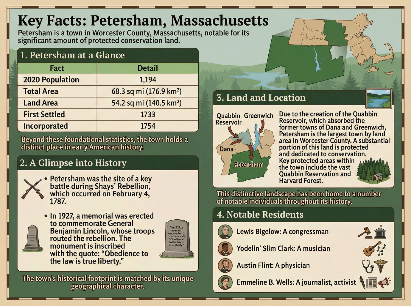
Key Facts: Petersham, Massachusetts
Petersham is a town in Worcester County, Massachusetts, notable for its significant amount of protected conservation land.
1. Petersham at a Glance
| Fact | Detail |
|---|---|
| 2020 Population | 1,194 |
| Total Area | 68.3 sq mi (176.9 km²) |
| Land Area | 54.2 sq mi (140.5 km²) |
| First Settled | 1733 |
| Incorporated | 1754 |
Beyond these foundational statistics, the town holds a distinct place in early American history.
2. A Glimpse into History
• Petersham was the site of a key battle during Shays’ Rebellion, which occurred on February 4, 1787.
• In 1927, a memorial was erected to commemorate General Benjamin Lincoln, whose troops routed the rebellion. The monument is inscribed with the quote: “Obedience to the law is true liberty.”
The town’s historical footprint is matched by its unique geographical character.
3. Land and Location
Due to the creation of the Quabbin Reservoir, which absorbed the former towns of Dana and Greenwich, Petersham is the largest town by land area in Worcester County. A substantial portion of this land is protected and dedicated to conservation. Key protected areas within the town include the vast Quabbin Reservation and Harvard Forest.
This distinctive landscape has been home to a number of notable individuals throughout its history.
4. Notable Residents
• Lewis Bigelow: A congressman.
• Yodelin’ Slim Clark: A musician.
• Austin Flint: A physician.
• Emmeline B. Wells: A journalist, activist.
————————————