


Discover Ashby Massachusetts – A Complete Profile
Ashby MA is the only town in Middlesex County covered by Gardner Magazine. We cover it because of its proximity and interaction with the Worcester County communities to its West. On this page is a complete profile and extensive infographic.
Listen to a “Deep Dive” about Ashby Massachusetts on any device, CLICK PLAY.
Town Profile: Ashby, Massachusetts
1.0 Overview
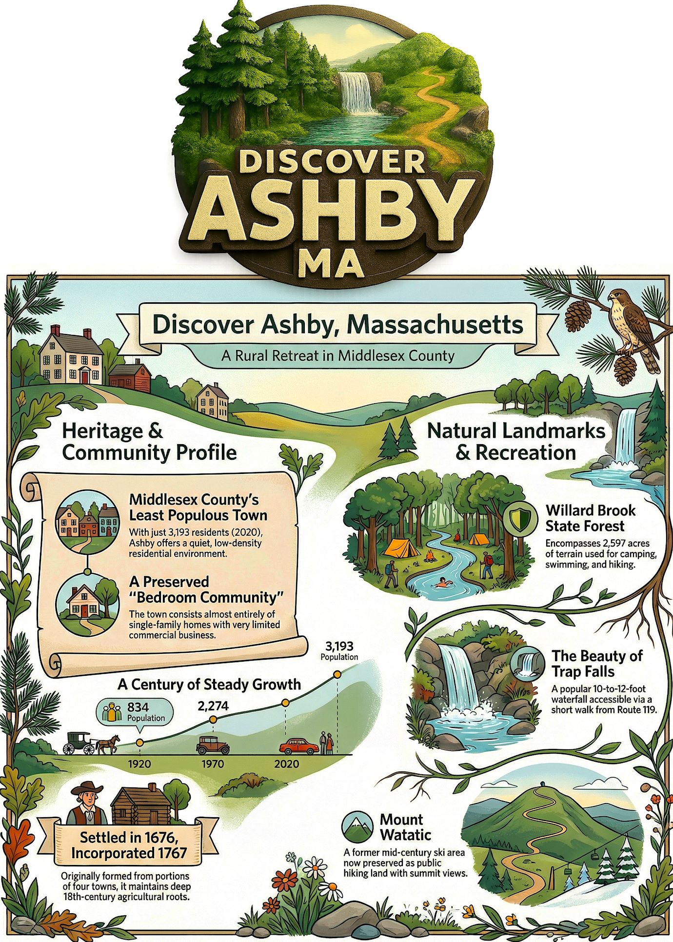
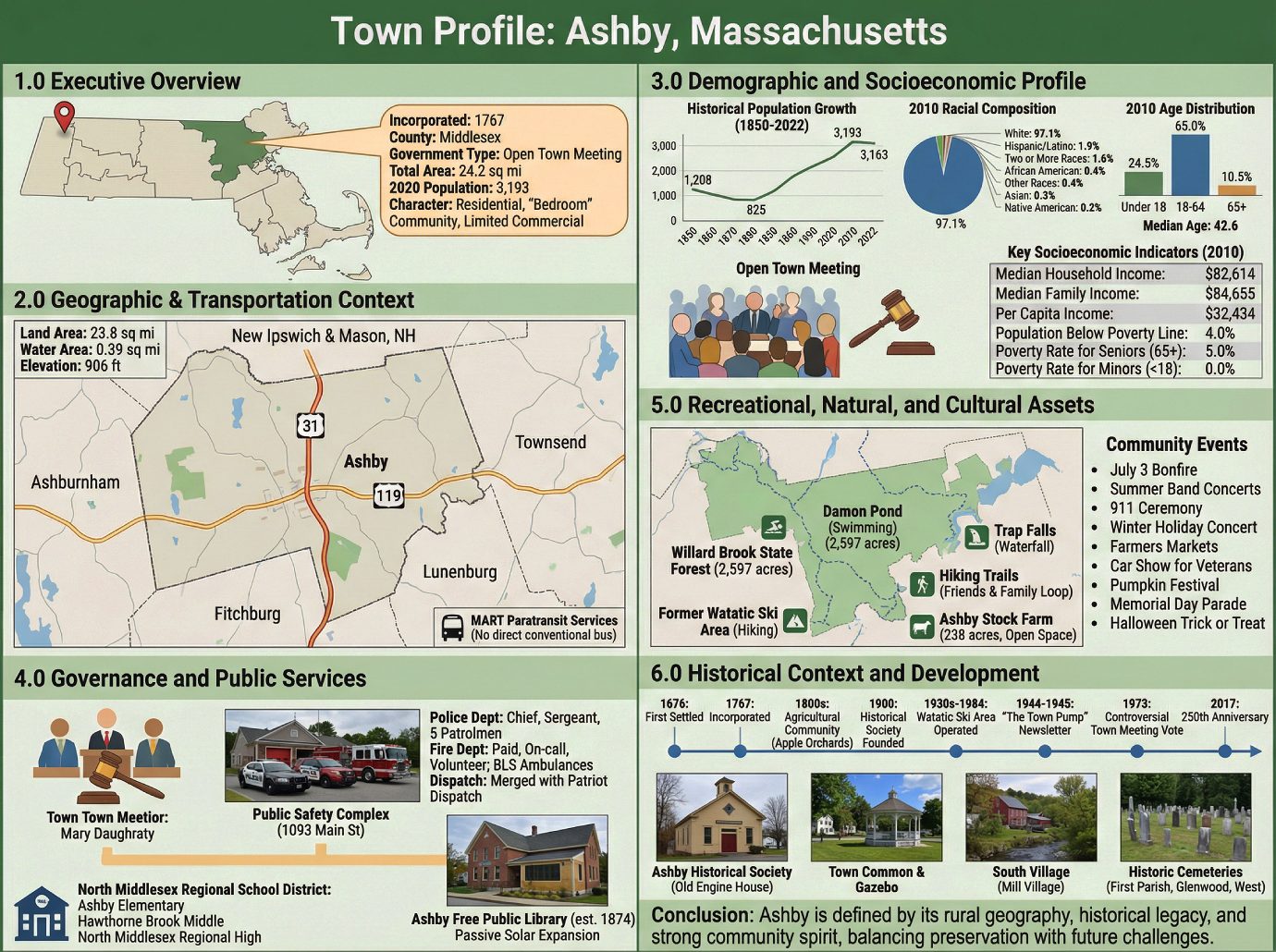
Ashby, Massachusetts, is a town located in the northwestern corner of Middlesex County, defined by its fundamental identity as a residential or “bedroom” community. Characterized by single-family homes and a limited commercial presence, Ashby is the least populous municipality in the county, with a population of 3,193 according to the 2020 U.S. Census. The following data provides a high-level snapshot of the town’s core attributes for strategic consideration.
• Incorporated: 1767
• County: Middlesex
• Government Type: Open town meeting
• Total Area: 24.2 sq mi
• 2020 Population: 3,193
• Character: Primarily single-family homes with limited business presence.
The following sections offer a detailed analysis of Ashby’s geographic, demographic, and civic features, providing a foundational understanding for informed decision-making.
2.0 Geographic & Transportation Context
For a rural town like Ashby, situated at the northwestern edge of Middlesex County, its geographic position and transportation corridors are fundamental determinants of its economic character and regional integration. This section analyzes Ashby’s physical setting and its connectivity to the broader region.
Geographic Specifications
• Total Area: 24.2 square miles (63 km²)
• Land Area: 23.8 square miles (61.6 km²)
• Water Area: 0.39 square miles (1.0 km²)
• Elevation: 906 feet (276 m)
Regional Position and Borders Ashby is bordered by New Ipswich and Mason, New Hampshire, to the north; Townsend to the east; Lunenburg to the southeast; Fitchburg to the south; and Ashburnham to the west. Ashby possesses a unique locational characteristic: it is the only town in Middlesex County that does not border more than one other town within the same county.
Transportation Network The town’s primary road arteries are Route 31, which runs north-south, and Route 119, which runs east-west. These two state highways briefly overlap just east of the town center. Regarding public transit, Ashby is a member of the Montachusett Regional Transit Authority (MART) but lacks direct conventional service; access is limited to paratransit services. The nearest conventional bus service is available in the neighboring city of Fitchburg.
This geographic framework, characterized by its rural expanse and limited transportation infrastructure, directly shapes the town’s low-density settlement patterns and demographic profile, which are examined in the subsequent section.
3.0 Demographic and Socioeconomic Profile
Demographic analysis is critical to understanding a community’s workforce capacity, housing requirements, and overall social fabric. This section provides a detailed breakdown of Ashby’s population, drawing on historical and recent census data to create a comprehensive socioeconomic snapshot.
Historical Population Growth: 1850-2022
Analysis of the data reveals a period of population decline in the late 19th century, followed by modest growth until mid-century. The most significant expansion occurred in the post-war era between 1950 and 1970, when the population more than doubled, marking Ashby’s transition into a modern residential community.
| Year | Population |
|---|---|
| 1850 | 1,208 |
| 1860 | 1,091 |
| 1870 | 994 |
| 1880 | 914 |
| 1890 | 825 |
| 1900 | 876 |
| 1910 | 885 |
| 1920 | 834 |
| 1930 | 982 |
| 1940 | 1,026 |
| 1950 | 1,464 |
| 1960 | 1,883 |
| 1970 | 2,274 |
| 1980 | 2,311 |
| 1990 | 2,717 |
| 2000 | 2,845 |
| 2010 | 3,074 |
| 2020 | 3,193 |
| 2022* | 3,163 |
*2022 figure is an estimate from the Population Estimates Program.
2020 Demographic Snapshot
Total Population: 3,193 Population Density: 134.0/sq mi (51.8/km²)
Detailed 2010 Census Data
A more granular analysis is available from the 2010 U.S. Census, which provides insights into household structure, racial composition, age, and income.
Households and Families
There were 1,105 households and 862 families in Ashby. The average household size was 2.86, and the average family size was 3.20.
Racial Composition
• White: 97.1%
• African American: 0.4%
• Native American: 0.2%
• Asian: 0.3%
• Other Races: 0.4%
• Two or More Races: 1.6%
• Hispanic or Latino (of any race): 1.9%
Age Distribution
The population’s age structure indicates a mature community, with a median age of 42.6 years. A significant portion of the population (24.5%) was under the age of 18, while 10.5% was 65 years of age or older.
Key Socioeconomic Indicators (2010)
Financial metrics reflect a stable, middle-to-upper-middle-income community with a very low poverty rate, particularly among minors.
• Median Household Income: $82,614
• Median Family Income: $84,655
• Per Capita Income: $32,434
• Population Below Poverty Line: 4.0%
• Poverty Rate for Seniors (65+): 5.0%
• Poverty Rate for Minors (Under 18): 0.0%
The town’s stable, family-oriented demographic profile and sound socioeconomic indicators underpin a civic structure reliant on volunteerism and regional partnerships, which in turn deliver the core public services examined next.
4.0 Governance and Public Services
A town’s governance structure and the quality of its public services are fundamental indicators of its operational health and attractiveness. Ashby is governed by a traditional Open town meeting structure and provides a comprehensive suite of essential public services.
Municipal Government
Ashby operates under an Open town meeting form of government, which allows for direct participation by registered voters in municipal legislative matters. The town’s day-to-day operations are overseen by the Town Administrator, Mary Daughraty.
Public Safety Infrastructure
In 2018-2019, the town constructed a unified Public Safety Complex at 1093 Main Street, which houses both the Police and Fire departments in a state-of-the-art facility.
• Police Department: The Ashby Police Department is composed of a Chief of Police, a Sergeant, and five full-time Patrolmen responsible for law enforcement and investigations.
• Fire Department: The Ashby Fire Department is a combination department utilizing paid, on-call, and volunteer personnel. It provides fire protection, rescue, and Emergency Medical Services (EMS). The department operates a fleet including multiple engines, a tanker, and two ambulances at the Basic Life Support (BLS) level.
• Dispatch Services: The town has merged its dispatch services with Patriot Dispatch, a move that has resulted in cost savings and successful operational integration.
Educational Framework
Ashby is a member town of the North Middlesex Regional School District, which it shares with Pepperell and Townsend. Students from Ashby attend Ashby Elementary School, Hawthorne Brook Middle School, and North Middlesex Regional High School.
Ashby Free Public Library
The Ashby Free Public Library, founded in 1874, is a significant civic and cultural institution. In 1901, the community received the donation of the current building from Edwin Chapman, a local businessman and Civil War veteran. In the early 2000s, the historic library underwent a significant expansion and renovation notable for its use of “passive solar” building techniques, which subsequently served as a model for the Massachusetts Board of Library Commissioners (MBLC).
The town’s investment in modern public safety infrastructure, coupled with its commitment to preserving historic civic assets like the library, indicates a governance model focused on both contemporary needs and historical character—a theme that extends to its recreational and cultural landscapes.
5.0 Recreational, Natural, and Cultural Assets
The assets that define a community’s character and quality of life are key considerations for potential residents and investors. Ashby is distinguished by its significant natural landscapes, conservation areas, and a robust calendar of community events.
Willard Brook State Forest
A major natural asset, the Willard Brook State Forest covers 2,597 acres within Ashby and is managed by the Massachusetts Department of Conservation and Recreation. The forest offers a wide range of year-round recreational opportunities, including camping, swimming, picnicking, hiking, horseback riding, mountain biking, cross-country skiing, and snowmobiling.
Key features within the forest include:
• Damon Pond: A man-made swimming pond constructed by the Civilian Conservation Corps (CCC) between 1933 and 1940.
• Hiking Trails: The forest contains numerous trails, including the four-mile Friends and Family Loop Trail that connects to the adjacent Pearl Hill State Forest.
• Trap Falls: A scenic waterfall with a height of 10 to 12 feet, accessible via a short walk from Route 119.
Other Significant Recreational and Open Spaces
• Former Watatic Ski Area: Located on Mount Watatic, this ski area operated from the 1930s until 1984. The land is now held in conservation and is accessible to the public for hiking. Remnants of the former ski lifts and structures are still visible on the mountain’s trails.
• Ashby Stock Farm: At 238 acres, this parcel of hay fields and forestland is the largest area of contiguous open space in Ashby. The farm is privately owned and used for horses and active hay production.
Community Events and Cultural Life
Ashby maintains a strong sense of community through a variety of annual events that foster civic engagement.
• Ashby July 3 Bonfire
• Summer Night Band Concerts on The Common
• 911 Ceremony
• Winter Holiday Band Concert
• Farmers Markets on The Common
• Annual Car Show For Veterans
• Pumpkin Festival and Tractor Parade
• Memorial Day Parade
• Halloween Downtown Trick or Treat
These community assets are deeply rooted in the town’s history, which has shaped its development and present-day identity.
6.0 Historical Context and Development
Understanding a town’s history provides essential context for its current physical layout, civic culture, and community identity. Ashby’s development from a colonial-era settlement to a modern residential town reflects its agricultural roots and rural character.
Origins and Early Development
The area was first settled in 1676 and officially incorporated as the Town of Ashby in 1767. The town was formed from unincorporated land and portions of the neighboring communities of Townsend, Lunenburg, Fitchburg, and Ashburnham. Historically, Ashby was a primarily agricultural community, once home to numerous apple orchards, the remnants of which can still be found in local woodlands.
Key Historical Points of Interest
• Ashby Historical Society: Founded in 1900, the society is located in the old engine house (c. 1899). It preserves and displays a collection of historical artifacts, including maps, books, farm implements, and early firefighting apparatus.
• Town Common and Gazebo: This central, triangular parcel of land is a key feature of the town center. Its historic gazebo was restored in the 2000s and remains a community landmark.
• South Village (Mill Village): An area that historically included a gristmill and sawmill circa 1800. Around 1902, the gristmill was retrofitted to produce electricity for the town center. The property is now owned by the Middlesex County Foundation and is operated by Camp Middlesex as a seasonal 4-H camp.
• Historic Cemeteries: The town owns and maintains three historic cemeteries: the First Parish Burial Ground (est. 1767), Glenwood Cemetery (est. 1867), and West Cemetery (which originated as a family burial ground during the Revolutionary War).
Notable Historical Events
• “The Town Pump”: From 1944 to 1945, this newsletter was published to keep residents serving in the World War II effort informed of local news.
• 1973 Town Meeting Vote: The town gained national attention in 1973 when the Town Meeting voted 148 to 79 against inviting non-white people to live in the community.
• 250th Anniversary: In 2017, Ashby celebrated its 250th anniversary with a year-long schedule of events, including a parade and a community bonfire.
Conclusion
In summary, Ashby is a community defined by the interplay of its rural geography and historical legacy. Its stable civic infrastructure and engaged citizenry have preserved a distinct small-town character, while its significant natural assets serve as both a key amenity for residents and a primary driver of its quality of life. For future planning, the central challenge will be balancing the preservation of this character against regional development pressures.