


Oakham MA – History and Overview
Oakham MA – The Enduring Identify of a New England Town
Community Profile: Oakham, Massachusetts
A Chronicle of Oakham, Massachusetts: From Colonial Settlement to Modern Community
Understanding Oakham, Massachusetts: A Simple Guide to its Demographics
Listen to a “Deep Dive” podcast about Oakham MA on any device, CLICK PLAY.
A Vanished Village, a Four-Fold Rebirth, and Other Secrets of a Tiny Massachusetts Town
Community Profile: Oakham, Massachusetts
Community Profile: Oakham, Massachusetts
Introduction: An Overview of Oakham
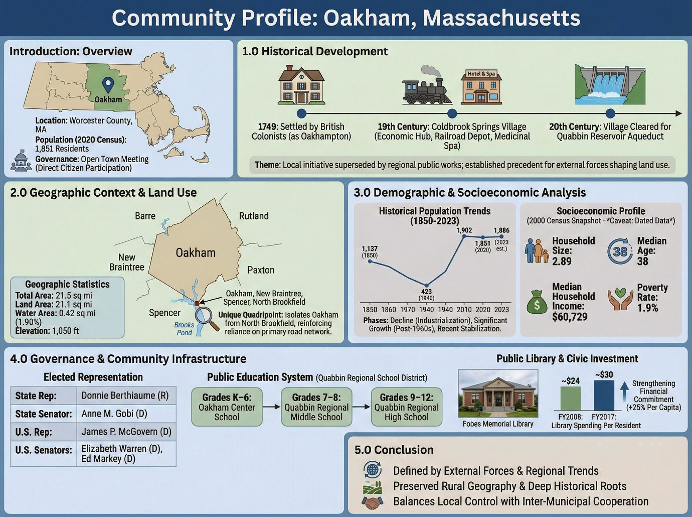
Oakham is a town located in Worcester County, Massachusetts. As of the 2020 U.S. Census, the town had a population of 1,851 residents. Governed by an Open town meeting, Oakham maintains a model of direct citizen participation in local legislative matters. This profile provides a detailed analysis of the town’s historical development, geographic context, demographic trends, and civic infrastructure to support municipal planning and development initiatives.
——————————————————————————–
1.0 Historical Development
A community’s history provides an essential framework for understanding its contemporary character, revealing foundational values and long-term development patterns that continue to influence its future. An examination of Oakham’s past highlights a transition from a modest colonial settlement to a community profoundly shaped by regional infrastructure projects and evolving land use priorities.
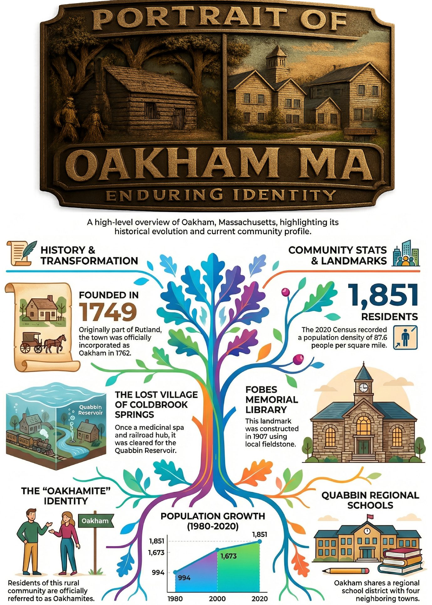
Oakham was first settled by British colonists in 1749 as a part of the larger Rutland territory. The town was officially incorporated, with sources conflicting on the precise year, citing both 1762 and 1775, and was initially named “Oakhampton,” though the reason for its subsequent shortening to Oakham is not recorded.
A significant element of the town’s past is the former village of Coldbrook Springs. This village emerged as a 19th-century hub of economic opportunity, growing around a natural iron spring and a railroad depot built in the 1830s to include a hotel, tavern, and medicinal spa. This local development was completely superseded by 20th-century regional public works when the entire village was cleared to accommodate the Quabbin Reservoir Aqueduct system. This narrative highlights a core tension between local economic initiative and the demands of broader public utility. Today, the area is part of the Massachusetts state forest within the protected Ware River Watershed.
The erasure of Coldbrook Springs for a regional water project established an early precedent for external forces shaping Oakham’s land use, a theme that continues to define its preserved rural geography.
2.0 Geographic Context and Land Use
A town’s physical layout, total area, and relationship with adjacent municipalities are fundamental factors that influence land use policy, infrastructure planning, and opportunities for regional cooperation. Oakham is defined by its rural landscape and a distinct set of geographic boundaries that dictate its access and development potential.
Geographic Statistics
• Total Area: 21.5 sq mi (55.8 km²)
• Land Area: 21.1 sq mi (54.7 km²)
• Water Area: 0.42 sq mi (1.1 km²), constituting 1.90% of the total area
• Elevation: 1,050 ft (320 m)
Oakham is bordered by Barre to the northwest, Rutland to the northeast, Paxton to the southeast, Spencer to the south, and New Braintree to the southwest.
A unique geographic characteristic exists at the town’s southern edge, where Oakham, New Braintree, Spencer, and North Brookfield share a common corner. This quadripoint is situated near the banks of Brooks Pond. This geographic anomaly functionally isolates Oakham from North Brookfield, reinforcing the town’s reliance on its primary road network for all inter-municipal access and regional integration.
This defined physical geography provides the container for a population whose demographic story is as dynamic as its landscape is constant.
3.0 Demographic and Socioeconomic Analysis
A deep understanding of demographic trends is essential for effective municipal planning, from forecasting housing needs to allocating public service resources. This section analyzes Oakham’s population dynamics, utilizing historical decennial census data to track long-term shifts, recent census counts for a current baseline, and the detailed socioeconomic breakdown from the 2000 decennial census.
Historical Population Trends (1850-2023)
The following table illustrates Oakham’s population fluctuations over more than 170 years, revealing distinct periods of decline, stability, and significant growth.
| Year | Population (Pop.) |
|---|---|
| 1850 | 1,137 |
| 1860 | 959 |
| 1870 | 860 |
| 1880 | 869 |
| 1890 | 738 |
| 1900 | 588 |
| 1910 | 552 |
| 1920 | 477 |
| 1930 | 502 |
| 1940 | 423 |
| 1950 | 455 |
| 1960 | 524 |
| 1970 | 730 |
| 1980 | 994 |
| 1990 | 1,503 |
| 2000 | 1,673 |
| 2010 | 1,902 |
| 2020 | 1,851 |
| 2023* | 1,886 |
• = population estimate.
Analysis of this data reveals three clear phases in Oakham’s demographic history. The first is a period of sustained population decline from 1850 (1,137 residents) to its lowest point in 1940 (423 residents), reflecting broader trends of rural depopulation in New England during industrialization. The second phase, beginning after 1960, is one of significant and sustained growth, with the population more than quadrupling between 1960 and 2010. This surge suggests Oakham’s evolution into a desirable residential community. The most recent decade shows a slight fluctuation, indicating a potential stabilization of this growth trend.
Current Population and Density
According to the 2020 U.S. Census, the total population of Oakham was 1,851. Based on a land area of 21.1 square miles, this yields a population density of approximately 87.6 people per square mile, reinforcing the town’s rural character.
Socioeconomic Profile (2000 U.S. Census)
Important Caveat: The following detailed socioeconomic data is from the 2000 U.S. Census. While it provides valuable insight into the town’s historical composition, it should be interpreted as a snapshot from over two decades ago. These figures are insufficient for current planning, and updated American Community Survey (ACS) data would be required for any meaningful contemporary socioeconomic analysis.
• Household Composition: Of the 578 households, 71.5% were married couples living together, and 41.5% had children under the age of 18. The average household size was 2.89.
• Age Distribution: The median age was 38 years. The population was distributed with 29.6% under the age of 18, 29.0% from 25 to 44, 27.5% from 45 to 64, and 7.8% who were 65 years of age or older.
• Racial Makeup: The town was predominantly white, at 98.33% of the population.
• Economic Indicators: The median household income was $60,729, and the per capita income was $23,175. The poverty rate was low, with 1.9% of the population living below the poverty line.
These demographic characteristics provide the essential context for understanding the governance structures and community services designed to support this population.
4.0 Governance and Community Infrastructure
A town’s governance model and its investment in public infrastructure, such as schools and libraries, are direct reflections of its civic priorities. These systems are critical for assessing a community’s quality of life, its capacity for future development, and its ability to meet the needs of its citizens.
Government and Representation
Oakham’s government operates on an Open town meeting model, a form of direct democratic rule common in New England. The town is represented at the state and federal levels by the following elected officials:
| Office | Official | Party |
|---|---|---|
| State Representative | Donnie Berthiaume | R |
| State Senator | Anne M. Gobi | D |
| Governor’s Councilor | Paul DePalo | D |
| U.S. Representative | James P. McGovern | D |
| U.S. Senator | Elizabeth Warren | D |
| U.S. Senator | Ed Markey | D |
Public Education System
Oakham is a member of the Quabbin Regional School District, a collaborative multi-town system that serves students from several area communities. The other member towns are Barre, Hardwick, Hubbardston, and New Braintree. This regional approach allows for the pooling of resources to provide comprehensive educational services. Students from Oakham follow this educational pathway:
• Grades K–6: Oakham Center School
• Grades 7–8: Quabbin Regional Middle School
• Grades 9–12: Quabbin Regional High School
Public Library and Civic Investment
The town’s public library serves as a key community anchor. The Oakham Free Public Library was established in 1892. In 1907, the current library building, the Fobes Memorial Library, was constructed using local fieldstone with funds donated by the Fobes family.
Analysis of municipal spending demonstrates a strengthening commitment to this institution.
• In fiscal year 2008, the town of Oakham allocated 1.71% of its budget ($47,657) to the library, which equated to approximately $24 per resident.
• In fiscal year 2017, the town allocated 1.66% of its budget ($58,062), equating to approximately $30 per resident.
While the library’s share of the municipal budget remained consistent, the 25% increase in per-capita spending from FY2008 to FY2017 demonstrates a strengthening financial commitment to this core community asset, outpacing population growth.
5.0 Conclusion
Oakham, Massachusetts, is a community whose development trajectory has been consistently defined by powerful external forces. From its colonial settlement and subsequent 19th-century depopulation driven by regional industrialization to the 20th-century erasure of a local village for a massive state water infrastructure project, the town’s story is one of adaptation to influences beyond its borders. This history has produced a community with deep historical roots, a distinctly rural and preserved geography, and a demographic profile that reversed a century of decline with robust late-20th-century growth.
Governed by a traditional Open town meeting and integrated into a regional school district, Oakham balances local control with inter-municipal cooperation. Its strengthening financial support for the public library signals a firm commitment to its core civic institutions. For planners and developers, Oakham presents as a town whose future trajectory will likely continue to be shaped by its relationship with broader regional trends, making an understanding of these external dynamics critical for any strategic engagement.
—————–
Understanding Oakham, Massachusetts: A Simple Guide to its Demographics
Understanding Oakham, Massachusetts: A Simple Guide to its Demographics
Introduction: Getting to Know Oakham
Understanding our community begins with understanding its people. This guide uses census data to paint a clear picture of the households and residents that make up Oakham, Massachusetts.
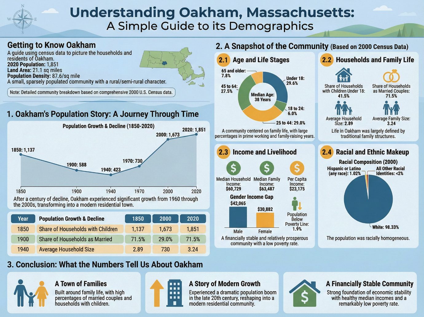
According to the most recent U.S. Census, the total population of Oakham in 2020 was 1,851 people. With a land area of 21.1 square miles, the town has a population density of 87.6 inhabitants per square mile. This figure suggests that Oakham is a small, sparsely populated community with a rural or semi-rural character.
Note: While the most recent total population figure is from the 2020 census, the detailed community breakdown in this guide is based on the comprehensive data collected during the 2000 U.S. Census, as provided in the source material.
To understand the community today, it’s helpful to first look at how its population has changed over time.
1. Oakham’s Population Story: A Journey Through Time
The historical data tells a story of significant transformation. After reaching a peak population in 1850, Oakham experienced a long period of decline that lasted for nearly a century. This trend reversed dramatically in the mid-20th century, with the town entering a period of significant and sustained growth from 1960 through the 2000s. This turnaround was not merely a recovery but a complete transformation, with the population more than quadrupling from its 1940 low of 423 to 1,673 by the year 2000. After a slight dip in the 2020 census, population estimates for 2023 suggest a return to this growth pattern.
The table below highlights key milestones in Oakham’s population history, illustrating the narrative of decline and subsequent regrowth.
| Year | Total Population |
|---|---|
| 1850 | 1,137 |
| 1900 | 588 |
| 1940 | 423 |
| 1970 | 730 |
| 2000 | 1,673 |
| 2020 | 1,851 |
This pattern of decline followed by strong regrowth since the 1960s implies a fundamental shift in the town’s development, likely evolving from an older, more isolated community into a modern residential town. Now, let’s examine a detailed snapshot of what this community looked like at a key point in its modern history.
2. A Snapshot of the Community (Based on 2000 Census Data)
The following details provide a deeper look into the town’s social and economic structure, based on the comprehensive data from the 2000 U.S. Census.
2.1. Age and Life Stages
The age distribution in 2000 reveals a community centered on family life. The large percentages of residents under 18 (nearly 30%) and those in the prime working and family-raising years of 25 to 64 (over 56% combined) strongly suggest that Oakham was predominantly a community of working-age families with children.
• Under 18: 29.6%
• 18 to 24: 6.0%
• 25 to 44: 29.0%
• 45 to 64: 27.5%
• 65 and older: 7.8%
The median age for the town’s population was 38 years.
2.2. Households and Family Life
The statistics on households reinforce the picture of a family-oriented town.
| Metric | Data Point |
|---|---|
| Share of Households with Children Under 18 | 41.5% |
| Share of Households as Married Couples | 71.5% |
| Average Household Size | 2.89 |
| Average Family Size | 3.24 |
These figures collectively show that in 2000, life in Oakham was largely defined by traditional family structures. With over 40% of households raising children and more than 70% being married couples, the community was composed primarily of multi-person family units rather than individuals living alone.
2.3. Income and Livelihood
The economic data from 2000 indicates a financially stable and relatively prosperous community.
• Median Household Income: $60,729
• Median Family Income: $63,487
• Per Capita Income: $23,175
• Population Below Poverty Line: 1.9%
A key insight is the significant gender income gap: the median income for males ($42,065) was over 11,000higherthanforfemales(30,882), meaning men earned approximately 36% more than women in the community.
Overall, the combination of healthy median incomes and a very low poverty rate suggests a general economic stability for the vast majority of the community’s residents in 2000.
2.4. Racial and Ethnic Makeup
The 2000 census data shows that the town’s population was racially homogeneous, with the vast majority of residents identifying as White.
• White: 98.33%
• Hispanic or Latino (of any race): 1.02%
All other racial identities, including African American, Asian, Native American, and multiracial individuals, collectively made up less than 2% of the population.
Having examined the details of the population, we can now step back and summarize what these numbers tell us about Oakham as a whole.
3. Conclusion: What the Numbers Tell Us About Oakham
Taken together, the demographic data from the turn of the century reveals three core truths about Oakham: it was a town built for families, defined by modern growth, and supported by a stable economic foundation.
1. A Town of Families With nearly a third of its population under 18, over 70% of its households led by married couples, and an average family size of 3.24, the data paints an unambiguous picture of a community built around family life. This suggests a town likely focused on issues such as school quality, public safety, and recreational spaces.
2. A Story of Modern Growth After nearly a century of decline, the town experienced a dramatic population boom in the late 20th century. This period of intense regrowth reshaped Oakham into the modern, residential community reflected in the 2000 census data.
3. A Financially Stable Community The combination of a median household income over $60,000 and a remarkably low poverty rate of just 1.9% indicates a strong foundation of economic stability for most residents at the turn of the century.
——————-
A Chronicle of Oakham, Massachusetts: From Colonial Settlement to Modern Community
A Chronicle of Oakham, Massachusetts: From Colonial Settlement to Modern Community
1.0 Introduction: The Enduring Identity of a New England Town
Nestled within Worcester County, the town of Oakham, Massachusetts, possesses a rich and distinct history that reflects the broader narrative of New England’s development. Understanding a community’s origins—its settlement, incorporation, and the pivotal moments that shaped its trajectory—is essential to appreciating its present-day character and civic identity. This chronicle traces the evolution of Oakham through its most significant historical phases, from its colonial beginnings and official establishment to the unique story of a lost village and its growth into a modern community. Anchored by its initial settlement in 1749, Oakham’s story is one of resilience, adaptation, and enduring community spirit. This narrative delves into the key milestones that have defined this quintessential New England town.
2.0 Colonial Roots: The Founding and Incorporation of Oakham
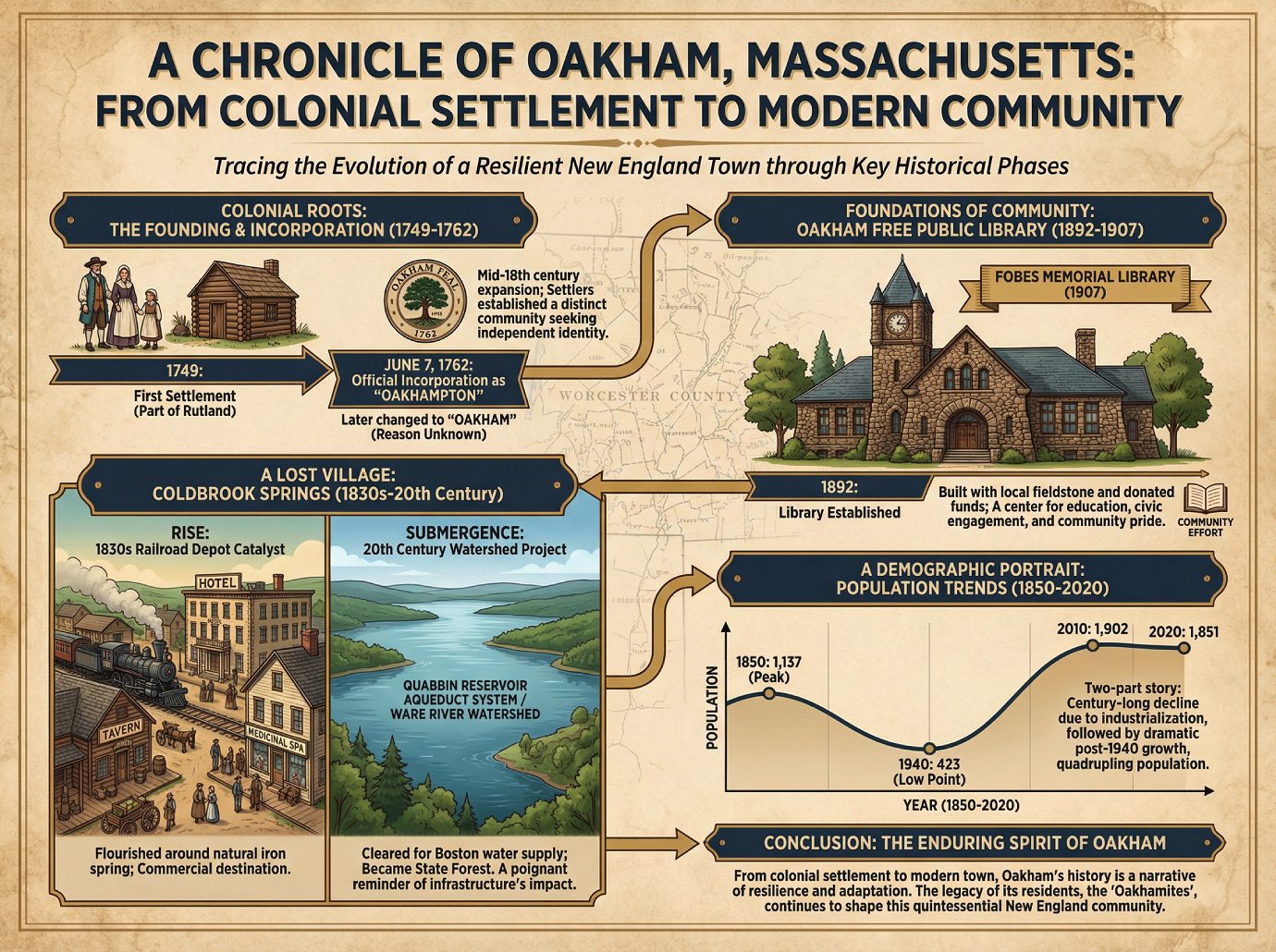
The mid-18th century was a period of significant colonial expansion across Massachusetts, as settlers pushed further inland to establish new communities. It was within this context that Oakham was founded. The area was first settled by British colonists in 1749, when it was still considered a part of the neighboring town of Rutland.
As the population grew and a distinct community began to form, the settlement sought its own independent identity. This was achieved on June 7, 1762, when it was officially incorporated as a distinct town (though some town records cite the year 1775). The new town was originally named Oakhampton. In a curious turn of events that adds a layer of historical intrigue, the name was later changed to “Oakham” for reasons that remain unknown to modern records. This formal establishment marked the beginning of Oakham’s long history as a self-governing entity in the heart of Massachusetts.
3.0 A Lost Village: The Rise and Submergence of Coldbrook Springs
The development of many 19th-century American towns was deeply intertwined with their natural resources, and communities often flourished around features like mineral springs, which were believed to have medicinal properties. Within Oakham, near the town line with Barre, such a community emerged: the village of Coldbrook Springs, established on the site of a natural iron spring.
The arrival of a railroad depot nearby in the 1830s was the catalyst that transformed this natural feature into a commercial destination, spurring the growth of a bustling village with a distinct identity. The village eventually featured several key amenities that catered to residents and travelers alike:
• A railroad depot
• A hotel
• A tavern
• A medicinal spa
Despite its success, the village’s existence was not permanent. In the 20th century, the entire area was designated as part of the Ware River Watershed, a critical component of the Quabbin Reservoir Aqueduct system designed to supply water to Boston. To protect the watershed, the village of Coldbrook Springs was entirely cleared of all its structures—houses, the hotel, and the spa—and its land became part of a Massachusetts state forest. This lost chapter in Oakham’s history serves as a poignant reminder of how regional infrastructure projects could fundamentally reshape local landscapes.
4.0 Foundations of Community: The Oakham Free Public Library
In the late 19th and early 20th centuries, public libraries became vital institutions in small New England towns. More than mere repositories for books, they were centers for education, civic engagement, and community pride, often funded through the dedication and philanthropy of local citizens. Oakham’s commitment to this ideal is embodied in its public library.
The Oakham Free Public Library was first established in 1892. As the institution grew, the need for a dedicated building became apparent. In 1907, this vision was realized with the construction of the Fobes Memorial Library building. The project was a true community effort, built with funds generously donated by the Fobes family and constructed from local fieldstone. The use of local fieldstone was not merely a practical choice but a symbolic one, grounding the town’s intellectual center in the very soil of the community it served.
5.0 A Demographic Portrait: Analyzing Oakham’s Population Through Time
Demographic data offers a powerful lens through which to view a town’s history, revealing periods of growth, stability, and decline that often correspond to broader economic and social shifts. The historical population figures for Oakham provide a clear and compelling narrative of the town’s evolution over nearly two centuries.
Historical Population of Oakham, Massachusetts (1850-2020)
| Year | Population |
|---|---|
| 1850 | 1,137 |
| 1860 | 959 |
| 1870 | 860 |
| 1880 | 869 |
| 1890 | 738 |
| 1900 | 588 |
| 1910 | 552 |
| 1920 | 477 |
| 1930 | 502 |
| 1940 | 423 |
| 1950 | 455 |
| 1960 | 524 |
| 1970 | 730 |
| 1980 | 994 |
| 1990 | 1,503 |
| 2000 | 1,673 |
| 2010 | 1,902 |
| 2020 | 1,851 |
An analysis of these trends reveals a distinct two-part story. From its 1850 peak of 1,137 residents, Oakham experienced a general decline that lasted for nearly a century, reaching its lowest recorded point of 423 people in 1940. This pattern was common in many rural New England towns during the era of industrialization and westward expansion. However, beginning in the mid-20th century, Oakham’s fortunes reversed dramatically. The town entered a period of sustained and substantial growth, more than quadrupling its population between 1940 and 2010 and establishing a new identity as a thriving modern community.
6.0 Conclusion: The Enduring Spirit of Oakham
From its origins as a colonial settlement carved from the wilderness to the resilient town it is today, Oakham’s history is a compelling narrative of change and continuity. The town’s journey includes its formal establishment, the rise and subsequent loss of the bustling spa village of Coldbrook Springs, the creation of cherished civic institutions like its fieldstone library, and dramatic demographic shifts that saw it evolve from a declining agricultural community to a growing modern town. Throughout these transformations, Oakham has demonstrated a remarkable ability to adapt. This history of resilience and community investment is the enduring legacy of its residents, known proudly as “Oakhamites.”
——————————
A Vanished Village, a Four-Fold Rebirth, and Other Secrets of a Tiny Massachusetts Town
A Vanished Village, a Four-Fold Rebirth, and Other Secrets of a Tiny Massachusetts Town
1.0 Introduction: The Secrets Hiding in Plain Sight
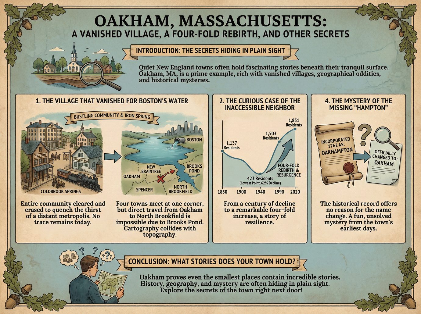
Quiet, unassuming towns dot the New England landscape, often seen as little more than sleepy dots on a map. Beneath their tranquil surface, however, these places often hold fascinating and unexpected stories. Oakham, Massachusetts, is a perfect example—a small town with a surprisingly rich history filled with vanished villages, geographical oddities, and historical mysteries.
2.0 1. The Village That Vanished for Boston’s Water
Within Oakham’s borders, near the town line with Barre, once stood the village of Coldbrook Springs. This was not just a small settlement, but a bustling community centered around a natural iron spring. The village boasted a hotel, a tavern, a medicinal spa, and its own railroad depot, built in the 1830s, that connected it to the wider world.
But today, you won’t find a single trace of it. The entire village was cleared of all structures because it is now part of the Ware River Watershed. An entire community was methodically erased, sacrificed to quench the thirst of a distant metropolis.
3.0 2. The Curious Case of the Inaccessible Neighbor
If you look at a map of Worcester County, you’ll see a point where four towns meet: Oakham, New Braintree, Spencer, and North Brookfield share a common corner. Logically, you would assume you could cross from Oakham into any of its three neighbors at this intersection. But you would be wrong.
There is no direct way to travel from Oakham to North Brookfield at this meeting point. The reason is simple: the shared corner is located just feet from the banks of Brooks Pond, making any direct road between the two towns a physical impossibility. This is a perfect real-world example of cartography colliding with topography—a reminder that lines on a map don’t always align with the physical landscape.
4.0 3. A Dramatic Population Rollercoaster
The story of Oakham’s population defies the typical narrative of steady rural decline. In 1850, the town was home to 1,137 residents. What followed was a long, slow decline that lasted for nearly a century. After a staggering 62% decline, the population hit a low of just 423 people in 1940.
Just when it seemed the town might fade away, a remarkable reversal began. The population surged, growing to 1,503 by 1990 and reaching 1,851 by the 2020 census. From its lowest point, the town’s population experienced a remarkable four-fold increase, telling a compelling story of resilience and modern resurgence.
5.0 4. The Mystery of the Missing “Hampton”
Every town has an origin story, but Oakham’s has a curious, unanswered question at its heart. When the town was officially incorporated back in 1762, it was given the name “Oakhampton.”
Sometime later, the name was officially changed to the simpler “Oakham.” The intriguing part? The historical record offers no reason for the change. Intriguingly, this small detail remains a fun, unsolved mystery from the town’s earliest days—a reminder that even official histories have their secrets.
6.0 Conclusion: What Stories Does Your Town Hold?
From a village sacrificed for water to a population that refused to disappear, Oakham proves that even the smallest places can contain incredible stories. It reminds us that history, geography, and mystery are often hiding in plain sight. What surprising stories might be hidden in the town right next door?
———————-
Key Facts About Oakham, Massachusetts
Key Facts About Oakham, Massachusetts
Introduction: Welcome to Oakham!
Welcome to your essential guide to Oakham, a small town located in the heart of Worcester County, Massachusetts. This document is designed to provide a clear and structured overview of the town’s most important characteristics, from its foundational history to its modern-day governance. Whether you’re a student of civics, geography, or simply curious about this New England community, the facts below offer a solid starting point for understanding what makes Oakham unique.
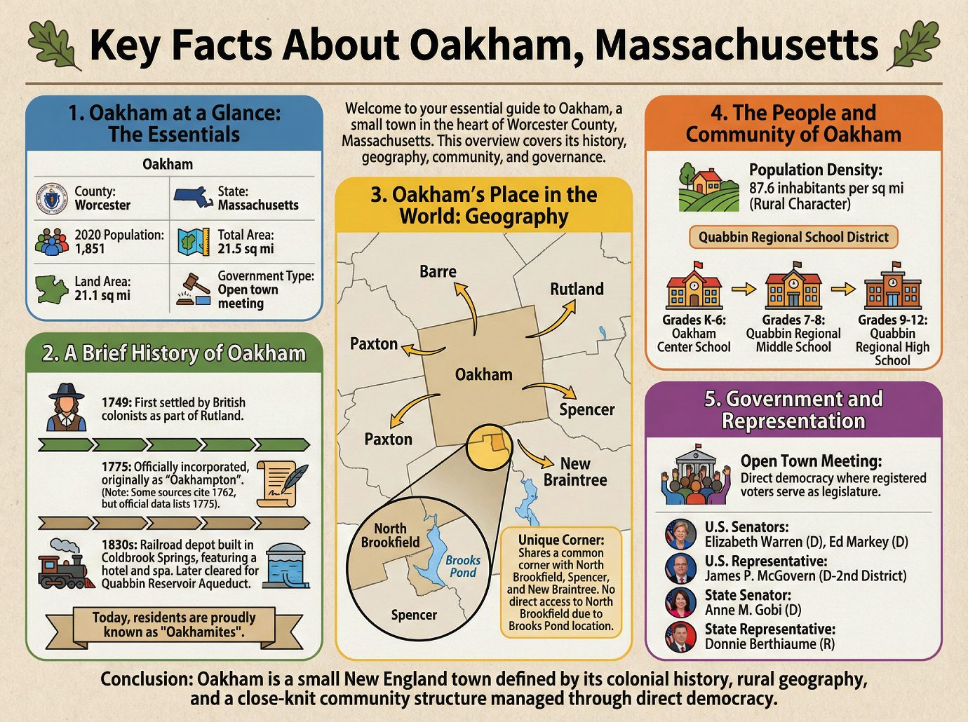
1. Oakham at a Glance: The Essentials
The most fundamental data about a town provides a snapshot of its size, population, and governing structure. The table below outlines these core facts for Oakham.
| Statistic | Details |
|---|---|
| County | Worcester |
| State | Massachusetts |
| 2020 Population | 1,851 |
| Total Area | 21.5 sq mi |
| Land Area | 21.1 sq mi |
| Government Type | Open town meeting |
These core statistics provide a snapshot of modern Oakham, but its identity is rooted in a rich history stretching back to the colonial era.
2. A Brief History of Oakham
Oakham’s past includes its origins as part of a larger settlement and the evolution of its villages over time.
Key Milestones
• 1749: The area was first settled by British colonists as a part of the neighboring town of Rutland.
• 1775: The town was officially incorporated, originally under the name “Oakhampton.” (Note: The body of the source text cites 1762, but the official town data lists 1775).
• 1830s: A railroad depot was built in the village of Coldbrook Springs, which was then a part of Oakham. This village, which featured a hotel, tavern, and medicinal spa, was later cleared to become part of the Quabbin Reservoir Aqueduct system.
Today, residents of the town are proudly known as “Oakhamites.” Oakham’s historical development is deeply tied to its physical setting in central Massachusetts.
3. Oakham’s Place in the World: Geography
Oakham occupies a total area of 21.5 square miles, with the vast majority—21.1 square miles—being land. This location places it in direct contact with several other towns in Worcester County.
Neighboring Towns
• Barre
• Rutland
• Paxton
• Spencer
• New Braintree
Interestingly, Oakham shares a common town corner with North Brookfield, Spencer, and New Braintree. However, due to this corner’s location within feet of the banks of Brooks Pond, there is no direct way to get to North Brookfield from Oakham. This distinct geography is the backdrop for the town’s community and population.
4. The People and Community of Oakham
According to the 2020 U.S. Census, Oakham is home to 1,851 residents, resulting in a population density of 87.6 inhabitants per square mile, reflecting its rural character.
A central part of the community is its school system. Oakham is a member of the Quabbin Regional School District, where students progress through the following schools:
• Grades K-6: Oakham Center School
• Grades 7-8: Quabbin Regional Middle School
• Grades 9-12: Quabbin Regional High School
This school system, like other public services, is managed by the town’s unique form of local government.
5. Government and Representation
Oakham operates under an Open town meeting form of government, a classic New England model of direct democracy where the town’s registered voters serve as the legislature. In addition to local governance, the town is represented by elected officials at the state and federal levels.
Oakham’s Federal & State Representatives
| Office | Official |
|---|---|
| U.S. Senators | Elizabeth Warren (D), Ed Markey (D) |
| U.S. Representative | James P. McGovern (D-2nd District) |
| State Senator | Anne M. Gobi (D) |
| State Representative | Donnie Berthiaume (R) |
6. Conclusion: Your Oakham Overview
Oakham is a small New England town defined by its colonial history, rural geography, and a close-knit community structure managed through direct democracy. With this overview, you now have a solid foundation of essential knowledge about this unique Massachusetts town.