


Hardwick – Agrarian Settlement to Modern Community
This page is dedicated to the History of Hardwick Massachusetts. Click on a link to jump to that section.
The first section is a Community Profile of Hardwick Massachusetts.
The second section goes over the Socio-Economic History of Hardwick.
The third section is called: From Tory Fairs to Ghost Towns: 5 Surprising Facts About Hardwick.
Gardner Magazine also has a “Deep Dive” about Hardwick, MA, Listen on any device, CLICK PLAY.
Community Profile: Hardwick, Massachusetts
Community Profile: Hardwick, Massachusetts
1.0 Introduction and Overview
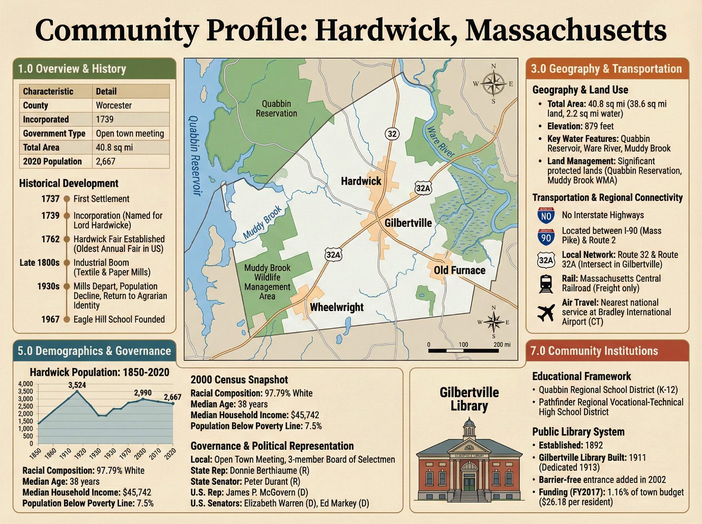
Hardwick is a town located in Worcester County, Massachusetts, positioned approximately 20 miles northwest of the city of Worcester. A community defined by its distinct villages and a rich agricultural heritage, Hardwick occupies a unique space in the region’s landscape. Its governance, geography, and demographics reflect a community deeply shaped by its agricultural heritage and the legacy of its 19th-century industrial boom and bust.
| Characteristic | Detail |
|---|---|
| County | Worcester |
| Incorporated | 1739 |
| Government Type | Open town meeting |
| Total Area | 40.8 sq mi |
| 2020 Population | 2,667 |
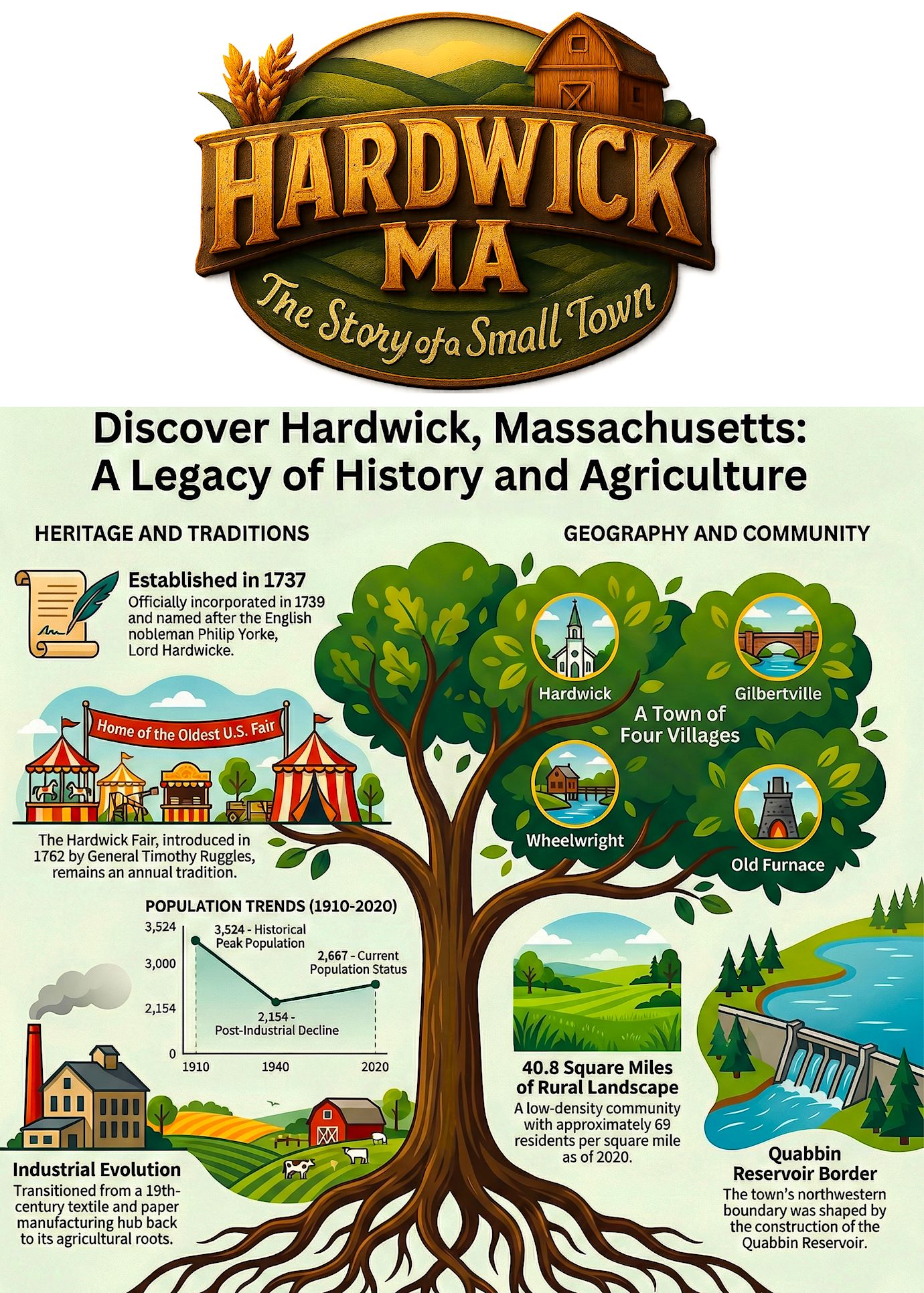
The town is composed of four distinct villages: Hardwick, Gilbertville, Wheelwright, and Old Furnace. This profile provides a detailed overview of the community, beginning with the historical events that have shaped its development.
2.0 Historical Development
To understand a community’s present condition and future trajectory, it is essential to examine its historical foundations. Key events, from initial settlement and economic transformations to the establishment of core institutions, have shaped Hardwick’s physical layout, economic base, and community identity.
Hardwick’s history began with its first settlement in 1737, followed by its official incorporation in 1739. The town was named in honor of Philip Yorke, Lord Hardwicke, a prominent English nobleman. A significant cultural milestone was established in 1762 when General Timothy Ruggles introduced the Hardwick Fair, which holds the distinction of being the oldest annual fair in the United States.
The town’s economy evolved significantly in the late 1800s with the growth of a manufacturing sector centered on textile and paper mills. This industrial base, however, proved transient; by the 1930s, the mills had departed the area, leading to a significant population decline. This economic shift prompted the town to revert to its agrarian identity, preserving the agricultural roots that continue to define its modern character. A key modern institution, Eagle Hill School, was founded in the town in 1967.
This economic arc, from agrarian roots through a brief industrial period and back, has preserved large tracts of undeveloped land, directly influencing the town’s present-day geography and land-use policies.
3.0 Geography and Land Use
Hardwick’s geography is a critical factor in municipal planning, influencing everything from development potential to conservation priorities. Its topography, significant water resources, and extensive protected lands create a distinct framework for the community’s physical character and future growth.
The town’s key physical characteristics include:
• Total Area: Hardwick covers 40.8 square miles, of which 38.6 square miles is land and 2.2 square miles (5.51%) is water.
• Elevation: The town has an elevation of 879 feet.
• Key Water Features: The creation of the Quabbin Reservoir altered the town’s boundaries; while some land area was lost, the town gained other lands, including a small portion of the disincorporated town of Greenwich. The reservoir’s waters extend into Hardwick along the former East Branch of the Swift River. The eastern portion of the town is drained by the Ware River, which is flanked by marshy lands, while the western part is drained by Muddy Brook.
• Land Management: A significant portion of the town’s land is protected. These areas include parts of the Quabbin Reservation and the Muddy Brook Wildlife Management Area.
Located on the western edge of Worcester County, Hardwick borders the towns of Petersham to the northwest, Barre to the northeast, New Braintree to the southeast, and Ware to the southwest. From its center, the town is 24 miles from Worcester, 31 miles from Springfield, and 64 miles from Boston, placing it within reach of several major urban centers. This sprawling, rural geography, with its protected lands and distinct village centers, necessitates a transportation network reliant on regional routes rather than major highways.
4.0 Transportation and Regional Connectivity
A town’s transportation infrastructure is fundamental to its economic vitality and the daily life of its residents. Hardwick’s position relative to major state transportation corridors shapes its access to regional markets, employment centers, and services.
Hardwick contains no interstate or limited-access highways. It is situated roughly halfway between Interstate 90 (the Massachusetts Turnpike) to the south and Route 2 to the north. The local road network is centered on the intersection of Route 32 and Route 32A in the village of Gilbertville. Route 32 connects Ware to the southwest with Barre to the northeast, while Route 32A runs north from Gilbertville through the town center toward Petersham, where its northern end lies.
The Massachusetts Central Railroad line passes through Hardwick, generally following the path of Route 32. However, this line is used for freight and does not offer passenger service. For air travel, the nearest private airport is the Tanner-Hiller Airport in New Braintree, and the nearest airport with national service is Bradley International Airport in Connecticut. This network of regional routes defines the daily commutes and economic access for the residents who constitute the town’s demographic profile.
5.0 Demographic Profile
Demographic data provides the statistical foundation for effective community planning, informing decisions related to housing, education, public services, and economic development. An analysis of Hardwick’s population reveals key trends and characteristics.
According to the 2020 U.S. Census, the total population of Hardwick was 2,667. With a land area of 38.6 square miles, this results in a population density of approximately 69.1 inhabitants per square mile.
Hardwick Population: 1850-2020
Historical census data illustrates the town’s population fluctuations over more than a century and a half, reflecting periods of industrial growth and subsequent decline.
| Year | Population |
|---|---|
| 1850 | 1,631 |
| 1860 | 1,521 |
| 1870 | 2,219 |
| 1880 | 2,233 |
| 1890 | 2,922 |
| 1900 | 3,203 |
| 1910 | 3,524 |
| 1920 | 3,085 |
| 1930 | 2,460 |
| 1940 | 2,154 |
| 1950 | 2,348 |
| 1960 | 2,340 |
| 1970 | 2,379 |
| 1980 | 2,272 |
| 1990 | 2,385 |
| 2000 | 2,622 |
| 2010 | 2,990 |
| 2020 | 2,667 |
While the 2020 census provides the most recent population count, a detailed demographic breakdown from the 2000 U.S. Census offers a historical baseline for understanding the town’s social and economic structure at the turn of the century.
• Racial Composition: The population was 97.79% White, 0.53% African American, 0.15% Native American, 0.11% Asian, 0.19% from other races, and 1.22% from two or more races. Hispanic or Latino of any race constituted 0.88% of the population.
• Age Distribution: The population was spread across age groups, with 28.0% under the age of 18, 6.9% from 18 to 24, 28.6% from 25 to 44, 22.7% from 45 to 64, and 13.7% who were 65 years of age or older. The median age was 38 years.
• Household and Family Structure: There were 997 households and 689 families. The average household size was 2.57, and the average family size was 3.08.
Key economic indicators from the 2000 census include:
• Median Household Income: $45,742
• Median Family Income: $54,667
• Per Capita Income: $20,824
• Population Below Poverty Line: 7.5%
The town’s demographic makeup directly informs the structure and responsibilities of its system of governance and political representation.
6.0 Governance and Political Representation
Hardwick’s system of local governance fits within the broader political landscape of Massachusetts and the United States. The town’s representation at the local, state, and federal levels ensures its interests are addressed across multiple jurisdictions.
At the local level, Hardwick operates under an Open Town Meeting form of government, a traditional New England model that allows for direct citizen participation. Executive authority is vested in a three-member Board of Selectmen. The current members are Robert Roy, Deana L. Talbot, and Eric Vollheim.
The town’s state and federal representatives are as follows:
| Office | Official(s) |
|---|---|
| State Representative | Donnie Berthiaume (R) |
| State Senator | Peter Durant (R) |
| Governor’s Councilor | Jen Caissie (R) |
| U.S. Representative | James P. McGovern (D-2nd District) |
| U.S. Senators | Elizabeth Warren (D), Ed Markey (D) |
This governmental structure is responsible for overseeing the community services and institutions that support residents.
7.0 Community Institutions and Services
Core community institutions, particularly schools and libraries, are vital to a town’s quality of life. They provide essential services, foster community engagement, and support the educational and personal development of residents.
Educational Framework
Hardwick is a member of the Quabbin Regional School District, a collaborative system that also serves the towns of Barre, Hubbardston, New Braintree, and Oakham. Students from Hardwick attend the district’s schools for elementary (K-6), middle (7-8), and high school (9-12) education. Additionally, Hardwick is part of the Pathfinder Regional Vocational-Technical High School District, providing students with access to specialized vocational training alongside nine other member communities.
Public Library System
The public library in Hardwick was established in 1892. The Gilbertville Library, located in one of the town’s villages, was constructed in 1911 and dedicated on March 29, 1913. The building retains its original character, with the notable addition of a barrier-free entrance completed in 2002 to improve accessibility while complementing the historic design.
The library’s funding reflects a consistent town commitment.
• In fiscal year 2008, the town allocated 1.58% ($64,023) of its budget to the library, an expenditure of approximately $24 per person.
• In fiscal year 2017, the library received 1.16% of the town budget, equivalent to $26.18 per resident.
Ultimately, Hardwick presents a profile of a resilient New England town. Its identity has been forged by a history of industrial decline that paradoxically preserved its agricultural character, a geography defined by protected reservoirs and rural landscapes, and a commitment to the local institutions that sustain its distinct villages. This interplay of history and geography continues to shape its community life in the modern era.
The Socio-Economic History of Hardwick, Massachusetts: From Agrarian Settlement to Modern Community
The Socio-Economic History of Hardwick, Massachusetts: From Agrarian Settlement to Modern Community
1.0 Introduction: An Overview of Hardwick’s Enduring Character
Located in Worcester County, Massachusetts, the town of Hardwick presents a compelling case study in the evolution of a New England community. This document provides a comprehensive historical narrative of Hardwick’s socio-economic development, tracing its journey from its 18th-century agrarian origins, through a transformative period of industrialization, to its modern identity. Over nearly three centuries, Hardwick’s story has been defined by several key themes: a deep-rooted agricultural tradition, the pivotal rise and fall of manufacturing, a significant geographic reshaping by the Quabbin Reservoir, and the demographic shifts that accompanied each major era. To understand the resilience that defines this community, one must first look to the agrarian foundations laid during its 18th-century colonial settlement.
2.0 Colonial Foundations and Agrarian Roots (1737 – Late 1800s)
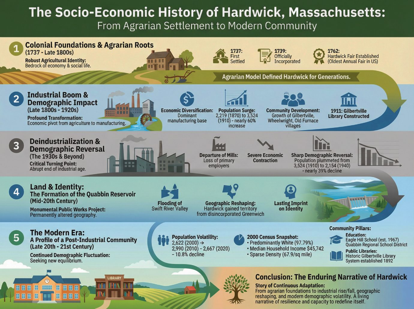
The colonial founding of Hardwick established a robust agricultural identity that would form the bedrock of its economy and social life for more than a century. This agrarian character, forged in the town’s earliest days, remains a significant part of its heritage.
First settled in 1737 and officially incorporated just two years later in 1739, the town was named in honor of Philip Yorke, Lord Hardwicke, an English nobleman. From its inception, the community’s livelihood was tied to the land. This deep connection to agriculture was institutionalized in 1762 with the introduction of the Hardwick Fair by General Timothy Ruggles. More than just an annual event, the fair became a foundational institution, symbolizing the town’s commitment to its agricultural economy and earning the distinction of being the oldest annual fair in the United States. For generations, this agrarian model defined Hardwick, a stable and enduring legacy that would soon be challenged by the forces of industrialization.
3.0 The Industrial Boom and Its Demographic Impact (Late 1800s – 1920s)
The late 19th century ushered in a period of profound transformation for Hardwick, marking a significant economic pivot from agriculture to manufacturing. The establishment of large-scale industrial operations fundamentally altered the town’s population and social geography, driving unprecedented growth and reorienting the community’s center of gravity.
During the late 1800s, Hardwick experienced a major expansion of its industrial base with the arrival of textile and paper mills. These factories, dependent on water power from the Ware River, created a powerful new engine for the local economy. This industrial boom had a direct and dramatic effect on the town’s population. After decades of modest size, the population surged from 2,219 in 1870 to its historical peak of 3,524 in 1910—an increase of nearly 60% that completely reoriented the town’s economic and social life.
The key impacts of this era represent a fundamental reshaping of the community:
• Economic Diversification: The town’s economy shifted from being primarily agrarian to a more complex model with a dominant manufacturing base.
• Population Surge: Hardwick experienced its most rapid and sustained period of population growth, driven directly by industrial employment.
• Community Development: New population centers grew around the mills, creating the distinct villages of Gilbertville, Wheelwright, and Old Furnace. This growth is evidenced by civic investment in new infrastructure, including the construction of the Gilbertville Library in 1911.
This period of industrial prosperity represented the zenith of Hardwick’s population and economic output, but the reliance on a narrow industrial base also made the community acutely vulnerable to the economic shifts that lay ahead.
4.0 Deindustrialization and Demographic Reversal (The 1930s and Beyond)
The 1930s marked another critical turning point for Hardwick, signaling the abrupt end of its industrial age. The departure of the town’s primary manufacturing employers triggered a severe economic contraction and a sharp demographic reversal, forcing the community to once again redefine itself.
By the 1930s, the textile and paper mills that had fueled Hardwick’s growth for over half a century had left the area. The loss of this industrial base had profound and immediate consequences. The population, which had peaked at 3,524 in 1910, plummeted to 2,460 by 1930 and continued to fall, reaching a low of 2,154 by 1940. This dramatic decline of nearly 39% in just three decades was a direct result of the loss of the mills, as workers and their families were forced to move elsewhere to find employment. This period of deindustrialization stripped the town of its primary economic driver and set the stage for the next major transformation in its landscape and identity.
5.0 Land and Identity: The Formation of the Quabbin Reservoir
In the mid-20th century, a monumental public works project permanently altered Hardwick’s geography and its relationship with the surrounding landscape. The creation of the Quabbin Reservoir to supply water to Eastern Massachusetts reshaped the town’s borders and physical character, leaving a lasting imprint on its identity.
The construction involved the flooding of the vast Swift River Valley. While losing some land area in this process, Hardwick was one of the towns that also gained territory. The reservoir’s waters now extend into its northwestern corner along the former East Branch of the Swift River. In a unique outcome of the project, Hardwick also gained a small portion of the disincorporated town of Greenwich, one of four communities submerged by the reservoir. This significant geographic transformation marked the end of an era of upheaval and provided the physical context for the town’s modern evolution.
6.0 The Modern Era: A Profile of a Post-Industrial Community
In the late 20th and early 21st centuries, Hardwick’s story has been one of continued demographic fluctuation, challenging any simple narrative of post-industrial recovery. Following the upheavals of the industrial and reservoir eras, the town has sought a new equilibrium as a rural community with strong connections to its past but an uncertain demographic trajectory.
An analysis of recent census data reveals a pattern of volatility rather than stability. After a mid-century low, the population recovered to 2,622 by 2000 and saw a surprising surge to 2,990 by 2010. However, this growth proved temporary, as the subsequent decade saw a significant 10.8% decline to a population of 2,667 in 2020. This recent reversal underscores the ongoing economic and social pressures facing small New England towns. A 2000 census snapshot offers context on the community’s character, showing it as predominantly White (97.79%), with a median household income of $45,742 and a sparse population density of 67.9 inhabitants per square mile.
Despite these demographic shifts, the strength of the contemporary town lies in its community institutions, which serve as pillars of civic life. These include:
• Education: Hardwick is home to the Eagle Hill School (founded in 1967) and participates in the Quabbin Regional School District.
• Public Libraries: The town’s public library system, first established in 1892, continues to serve the community. The historic Gilbertville Library, a remnant of the industrial era, stands as a testament to the town’s enduring commitment to civic investment.
7.0 Conclusion: The Enduring Narrative of Hardwick
The socio-economic evolution of Hardwick, Massachusetts, is a story of continuous adaptation. From its quiet agrarian foundations, the town was fundamentally reshaped by a dramatic industrial rise and subsequent fall that dictated its demographic destiny for nearly a century. This was followed by a permanent physical transformation with the creation of the Quabbin Reservoir. In the modern era, Hardwick has not settled into a simple stability but continues to navigate demographic volatility, as evidenced by its population decline between 2010 and 2020. The town’s nearly 300-year journey is not a closed chapter but a living narrative of resilience, demonstrating a remarkable capacity to endure and redefine itself in the face of ongoing change.
From Tory Fairs to Ghost Towns: 5 Surprising Facts About Hardwick, MA
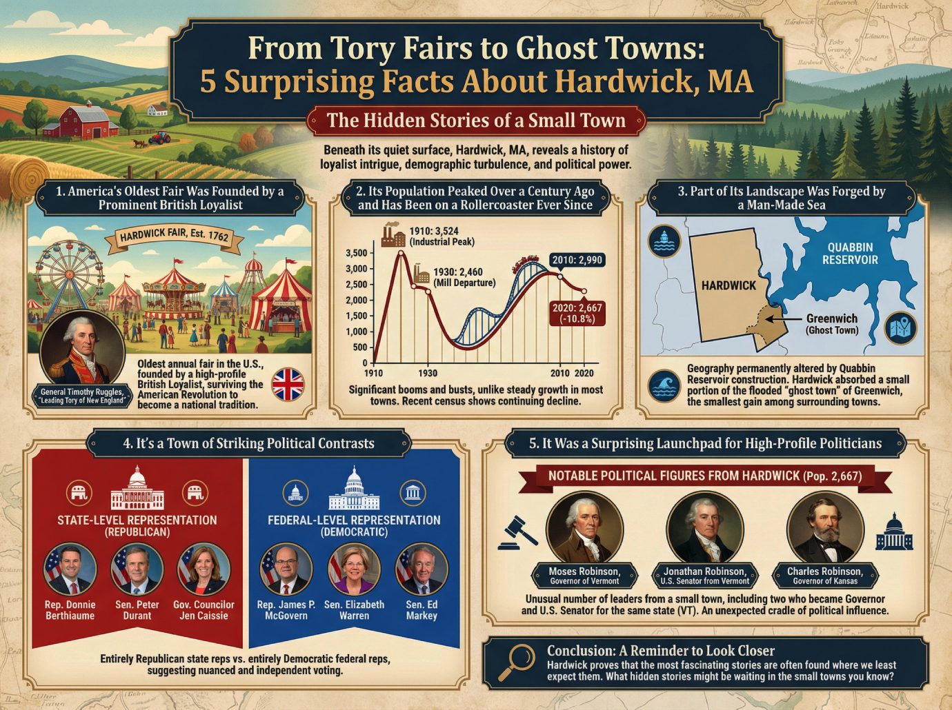
From Tory Fairs to Ghost Towns: 5 Surprising Facts About Hardwick, MA
Introduction: The Hidden Stories of a Small Town
New England is known for its quiet towns that seem preserved in time, and at first glance, Hardwick, Massachusetts, fits the image perfectly. But beneath its placid surface of farms and forests lies a history of loyalist intrigue, demographic turbulence, and an astonishing knack for producing political power. This article uncovers some of the most unexpected facts about this small Worcester County town.
——————————————————————————–
1. America’s Oldest Fair Was Founded by a Prominent British Loyalist
Hardwick is home to the Hardwick Fair, which is now the oldest annual fair in the United States. In a striking twist of history, it was established in 1762 by General Timothy Ruggles, described as “one of the leading Tories of New England.” It is remarkable that an institution founded by a high-profile loyalist to the British crown not only survived the American Revolution but evolved into a celebrated national tradition.
2. Its Population Peaked Over a Century Ago and Has Been on a Rollercoaster Ever Since
Unlike most American towns that have experienced steady growth, Hardwick’s population has seen significant booms and busts. The town reached its industrial-era peak of 3,524 residents in 1910. But this boom was short-lived. By 1930, the town’s population had plummeted to just 2,460, a period that coincides with the departure of the area’s textile and paper mills. This pattern of fluctuation continues, with the most recent census data showing a population drop of 10.8% between 2010 (2,990 people) and 2020 (2,667 people).
3. Part of Its Landscape Was Forged by a Man-Made Sea
Hardwick’s geography was permanently altered by the construction of the Quabbin Reservoir in the 20th century. While the project resulted in the town both gaining and losing land, its most surprising consequence came from the disincorporation of towns that were flooded to create the reservoir. Hardwick absorbed a small portion of the former “ghost town” of Greenwich. In a final twist, this addition to its territory was the smallest portion of land gained by any of the towns surrounding the reservoir.
4. It’s a Town of Striking Political Contrasts
When it comes to politics, Hardwick is a fascinating puzzle. The town’s state-level government representation is entirely Republican: State Representative Donnie Berthiaume, State Senator Peter Durant, and Governor’s Councilor Jen Caissie are all members of the Republican party. In stark contrast, its federal-level representation is entirely Democratic, with James P. McGovern in the U.S. House of Representatives and Elizabeth Warren and Ed Markey in the U.S. Senate. This distinct local/federal split suggests a nuanced and independent voting pattern within the community.
5. It Was a Surprising Launchpad for High-Profile Politicians
For a town with a current population of only 2,667, Hardwick has an unusual number of notable political figures connected to it. Among the leaders who hailed from this small community are:
• Moses Robinson, Governor of Vermont
• Jonathan Robinson, United States Senator from Vermont
• Charles Robinson, Governor of Kansas
What makes this list even more remarkable is that two of these figures, Moses and Jonathan Robinson, went on to become the Governor and a U.S. Senator for the same state. It is highly unusual for a single, rural town to be connected to multiple state governors and a U.S. Senator, marking it as an unexpected cradle of political influence.
——————————————————————————–
Conclusion: A Reminder to Look Closer
Hardwick is a town founded by a British loyalist that went on to launch American governors, a landscape partially erased to quench a city’s thirst, and a community that votes for different parties at the state and federal level. It proves that the most fascinating stories are often found where we least expect them. What hidden stories might be waiting in the small towns you know?