


Athol Massachusetts – The Tool Town
This page is about Athol, Massachusetts, the “Tool Town”
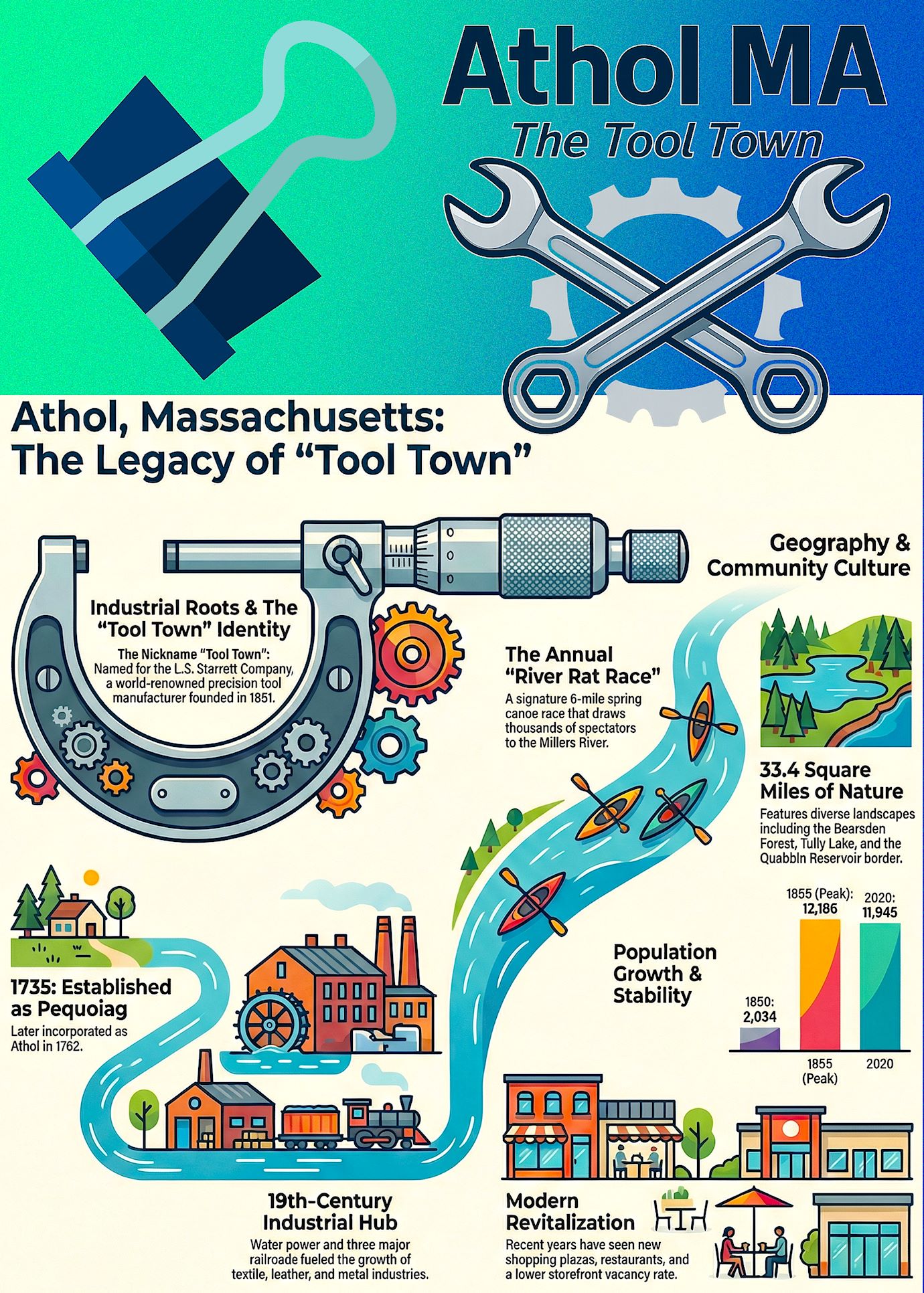
View Infographic and a narrative on the Story of Athol from Pequoiag to Tool Town.
View infographic and a narrative on 4 Surprising Stories that shaped Athol, Massachusetts.
Listen to a “Deep Dive” on any device, CLICK PLAY.
OVERVIEW
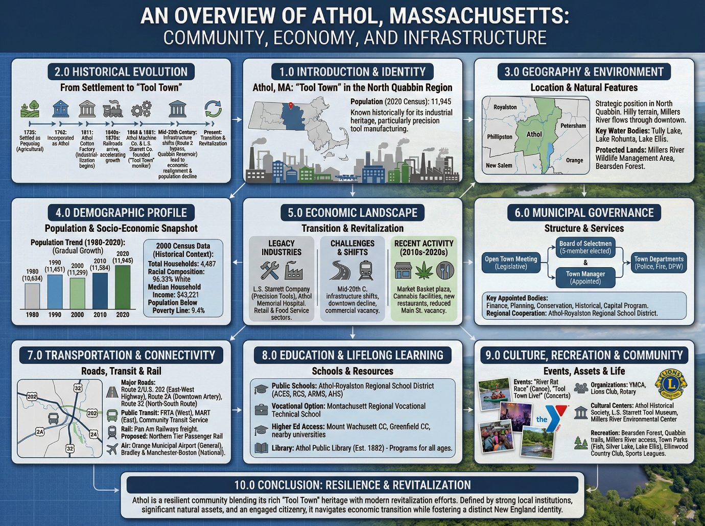
An Overview of Athol, Massachusetts: Community, Economy, and Infrastructure
1.0 Introduction to Athol, Massachusetts
1.1 Athol is a town located in Worcester County, Massachusetts, known historically by its nickname “Tool Town.” With a population of 11,945 recorded in the 2020 U.S. Census, the community holds a distinct position in the North Quabbin region of the state.
1.2 This document provides a comprehensive and objective overview of Athol’s historical development, geography, demographics, economy, and public infrastructure. It is designed to serve as a foundational resource for civic leaders, municipal planners, economic development professionals, and individuals considering relocation to the area.
2.0 Historical Evolution: From Settlement to “Tool Town”
2.1 Introduction Understanding a town’s history is essential for interpreting its present-day economic and social landscape. Athol’s evolution from a small agricultural settlement to a significant industrial center provides critical context for its modern identity, challenges, and opportunities.
2.2 Early Settlement and Industrialization The area was first settled by five families in 1735, when it was known as Pequoiag. The township was formally incorporated in 1762 and renamed Athol. The early economy was based on agriculture, but the town’s numerous waterways soon powered a new industrial base. As industries developed along the river valley, a commercial and residential center known as “Uptown” grew up on the hill southeast of the factories. By 1791, Athol was home to four gristmills and six sawmills. This industrialization expanded with the establishment of the Athol Cotton Factory in 1811, one of the first local industries to serve a market beyond the immediate area.
2.3 The Rise of Industry and Transportation The arrival of the Vermont and Massachusetts Railroad in the 1840s dramatically accelerated Athol’s industrial growth. This expansion was so significant that a second rail line connecting Athol to Springfield was built in 1870, followed by the east-west Fitchburg Railroad in 1879. This robust transportation network attracted numerous manufacturers and cemented the town’s identity. The “Tool Town” moniker originated during this period with the founding of the Athol Machine Company in 1868 and the L. S. Starrett Company in 1881. Founded by Laroy S. Starrett, the L. S. Starrett Company grew to become, and remains, the town’s largest employer.
2.4 20th Century Shifts and Economic Realignment A confluence of mid-20th-century infrastructure developments fundamentally realigned Athol’s economic trajectory and severed key commercial connections. The rise of the automobile led to the closure of local trolley lines in the 1930s. Concurrently, the creation of the Quabbin Reservoir required the abandonment of the Springfield railroad route. The construction of the Route 2 bypass in the 1950s further diverted traffic and commerce away from the traditional downtown business district. This realignment is reflected in the town’s population trends: after reaching a peak of 12,186 residents in 1955, the population declined to a low of 10,634 in 1980 before beginning a period of gradual growth.
2.5 Transition This historical trajectory established the foundational industrial and transportation patterns that continue to influence the town’s physical setting and development.
3.0 Geography and Physical Environment
3.1 Introduction A town’s geography and location are fundamental to its character, shaping its development patterns, recreational opportunities, and regional identity.
3.2 Location and Proximity Athol is situated in the North Quabbin region of Massachusetts, holding a strategic position between several key urban centers.
• County: Located on the western edge of Worcester County, bordering Franklin County.
• Bordering Towns: Royalston (north), Phillipston (east), Petersham (south), New Salem (southwest), and Orange (west).
• Proximity to Major Cities: Athol is approximately 23 miles from Greenfield, 25 miles from Fitchburg, 35 miles from Worcester, and 67 miles from Boston.
3.3 Topography and Natural Features The town’s landscape is characterized by hilly terrain with rough and stony soil. Elevations range from 500 feet above sea level along the Millers River to a high point of 1,282 feet at Pratt Hill. The town is drained primarily by the Millers River, which flows through the downtown area. Key water bodies include portions of Tully Lake and Lake Rohunta, as well as the entirety of Lake Ellis. Athol also contains significant protected lands that contribute to its rural character, including the Millers River Wildlife Management Area and Bearsden Forest.
3.4 Transition The town’s physical layout and natural assets provide the setting for the community and its demographic profile.
4.0 Demographic Profile
4.1 Introduction Demographic data provides a statistical snapshot of a community’s composition, offering essential information for planning public services in areas such as housing, education, public health, and economic development.
4.2 Population Data and Trends As of the 2020 U.S. Census, the population of Athol was 11,945. The town has experienced a trend of gradual growth since its low point in 1980, as illustrated in the following table.
| Year | Population |
|---|---|
| 1980 | 10,634 |
| 1990 | 11,451 |
| 2000 | 11,299 |
| 2010 | 11,584 |
| 2020 | 11,945 |
4.3 2000 Census Household and Economic Data The most recent detailed socio-economic data available in the source is from the 2000 U.S. Census and is presented below for historical context.
• Total Households: 4,487
• Racial Composition: 96.33% White, with significant populations of French, French Canadian, English, Irish, and Italian ancestry.
• Median Household Income: $43,221
• Median Family Income: $49,440
• Per Capita Income: $21,267
• Population Below Poverty Line: 9.4%
This 2000 data provides a historical baseline, though current figures would likely reflect broader regional demographic shifts.
4.4 Transition This demographic foundation is supported by the local and regional economic conditions and employment opportunities that support the population.
5.0 Economic Landscape and Development
5.1 Introduction A town’s economic base defines its stability, employment opportunities, and potential for future growth. Athol’s economy is in a period of transition, moving from its historic industrial identity toward a more diversified model.
5.2 Legacy Industries and Major Employers Athol’s economic history is rooted in manufacturing, earning it the nickname “Tool Town.” The two largest employers in the town are the L. S. Starrett Company, continuing its legacy in precision tool manufacturing, and Athol Memorial Hospital. Outside of these major employers, most jobs in Athol are concentrated in the retail and food service sectors.
5.3 Economic Challenges and Revitalization Efforts The transportation shifts of the mid-20th century, particularly the construction of the Route 2 bypass and the loss of the Springfield rail line, directly contributed to a period of economic decline for Athol’s downtown core. A state-funded economic development push in the 1980s showed promise until a recession stalled progress. The challenges were compounded in the 1990s when the opening of a Walmart in neighboring Orange drew commerce away from Athol’s Main Street, contributing to a commercial vacancy rate of 18% by 1998. In response, collaborative organizations were formed to promote economic growth, including the Orange-Athol Industrial Development Commission and the Millers River Community Development Corporation.
5.4 Recent Economic Activity (2010s-2020s) The last decade has shown signs of economic renewal, with several notable commercial and industrial developments:
• Development of a new shopping plaza anchored by a Market Basket supermarket, which also includes a movie theater and other retail and dining establishments.
• Conversion of a portion of the former Union Twist Drill mill for use as a marijuana-growing facility by Massgrow.
• The opening of two cannabis dispensaries and several new restaurants.
• A tangible reduction in storefront vacancy rates on Main Street compared to the previous decade.
5.5 Transition This economic activity is overseen and supported by the town’s municipal government structure that manages public services and planning.
6.0 Municipal Governance and Public Services
6.1 Introduction A clear understanding of a town’s municipal governance is crucial for residents and businesses to effectively engage with civic processes and access essential public services.
6.2 Government Structure Athol operates under a Town Charter passed in 2000. The form of government is an Open Town Meeting, with the town’s administration managed by an elected five-member Board of Selectmen and an appointed Town Manager. Key appointed bodies that contribute to town administration include the Finance and Warrant Advisory Committee, Planning Board, Conservation Commission, Historical Commission, and Capital Program Committee.
6.3 Public Safety and Works Core municipal services are provided by dedicated town departments: the Athol Fire Department, the Athol Police Department, and the Department of Public Works, which is responsible for roadways, water, sewage treatment, parks, and cemeteries. A Massachusetts State Police barracks is also located in Athol.
6.4 Regional Cooperation Despite being in Worcester County, Athol maintains a strong cooperative relationship with its neighbor, Orange, which is in Franklin County. A primary example of inter-town partnership is the Athol-Royalston Regional School District.
6.5 Transition These departments and cooperative agreements depend on the town’s physical infrastructure, particularly its transportation network.
7.0 Transportation and Regional Connectivity
7.1 Introduction A community’s transportation infrastructure is vital for economic access, residential commuting, and overall connectivity to the broader region. Athol is primarily dependent on its road network for transportation.
7.2 Road Network The town is served by several key state and federal highways.
• Route 2 / U.S. Route 202: This is the major east-west limited-access highway in the region, connecting Athol to Greenfield in the west and the greater Boston area in the east.
• Route 2A: The former alignment of Route 2, this road serves as the main artery through downtown Athol and connects directly to Orange and Gardner.
• Route 32: This is the primary north-south route, connecting Athol to Petersham in the south and Royalston to the north.
7.3 Public and Commercial Transit Bus services connect Athol to the surrounding region. The Franklin Regional Transit Authority (FRTA) provides service to destinations westward, while the Montachusett Area Regional Transit (MART) offers routes to the east. Additionally, the Community Transit Service operates dial-a-ride services for local residents. Intercity bus service is available in nearby cities.
7.4 Rail and Air Access A Pan Am Railways freight line is active through the town. A proposal known as “Northern Tier Passenger Rail” is in the planning stages to extend MBTA commuter rail service through Athol, which would restore passenger rail to the area. The closest airport for general aviation is the Orange Municipal Airport, while the nearest airports with national service are Bradley International Airport and Manchester-Boston Regional Airport.
7.5 Transition This transportation network provides vital links for residents and supports the community’s educational resources, which serve the families within the community.
8.0 Education and Lifelong Learning
8.1 Introduction The local education system is a cornerstone of community life, serving as a primary consideration for families deciding where to live and playing a key role in developing the future workforce.
8.2 Public School System Public education is provided by the Athol-Royalston Regional School District, which includes Athol Community Elementary School (Pre-K to 4), Royalston Community School (K–6), Athol-Royalston Middle School (5 to 8), and Athol High School (9 to 12). Students also have the option to attend Montachusett Regional Vocational Technical School in Fitchburg.
8.3 Higher Education and Library Services The closest community colleges are Mount Wachusett Community College in Gardner and Greenfield Community College. Bachelor’s and graduate degree programs are available at state universities and private colleges in nearby cities such as Fitchburg and Amherst. The Athol Public Library, established in 1882, serves as a vital center for lifelong learning, offering programs for preschoolers, children, and a Teen Advisory Council (ATAC) that organizes events for young adults.
8.4 Transition Beyond formal education, the town’s culture and community life offer a wide array of social, recreational, and cultural activities.
9.0 Culture, Recreation, and Community Life
9.1 Introduction A town’s cultural assets and recreational opportunities are vital indicators of its quality of life, reflecting the presence of an active and engaged community.
9.2 Community Events and Organizations As a result of its relative geographic isolation from major urban centers, Athol has cultivated a resilient, self-reliant community culture where residents foster their own entertainment. This is highlighted by major annual events, including the “River Rat Race,” a popular canoe race on the Millers River, and the “Tool Town Live!” summer concert series. These activities are driven by key community organizations such as the Athol Area YMCA, the Athol Lions Club, and the Athol-Orange Rotary.
9.3 Cultural and Environmental Centers Several institutions preserve and celebrate the town’s heritage and natural environment.
• Athol Historical Society: Housed in the old town hall, the society operates a museum of local history and hosts educational programs.
• L.S. Starrett Tool Museum: Located at the Starrett Company headquarters, this museum displays historic machine tools and is available to visitors by appointment.
• Millers River Environmental Center: This center is a regional hub for environmental programs and is home to the Athol Bird and Nature Club.
9.4 Parks and Outdoor Recreation Athol offers extensive opportunities for outdoor recreation. Natural areas include Bearsden Forest, hiking trails near the Quabbin Reservoir, and canoe access to the Millers River via the Alan E. Rich Environmental Park. Town parks like Fish Park, Silver Lake, and Lake Ellis provide facilities for swimming, skating, and sports. Private facilities include the Ellinwood Country Club for golf and the Athol Area YMCA for fitness. Community-based youth and adult sports, such as Chuck Stone Little League and the Silver Lake Wiffleball League, are also popular. The town is also home to the Mount Grace Land Conservation Trust, a key regional organization that works to protect natural and scenic areas.
9.5 Transition These varied aspects of community life combine to form a comprehensive profile of the town.
10.0 Conclusion: A Synthesis of Athol’s Community Profile
10.1 Athol, Massachusetts, is a community deeply shaped by its rich industrial heritage as “Tool Town” and its location within the scenic North Quabbin region. While navigating the economic transitions of the 21st century, the town demonstrates a clear commitment to revitalization, evidenced by recent commercial development and active community-led initiatives.
10.2 The town’s profile is one of resilience and self-reliance, defined by its strong local institutions, significant natural and recreational assets, and an engaged citizenry. Athol’s blend of historic character, accessible infrastructure, and a robust community life positions it as a distinctive and evolving New England town.
STORY OF ATHOL
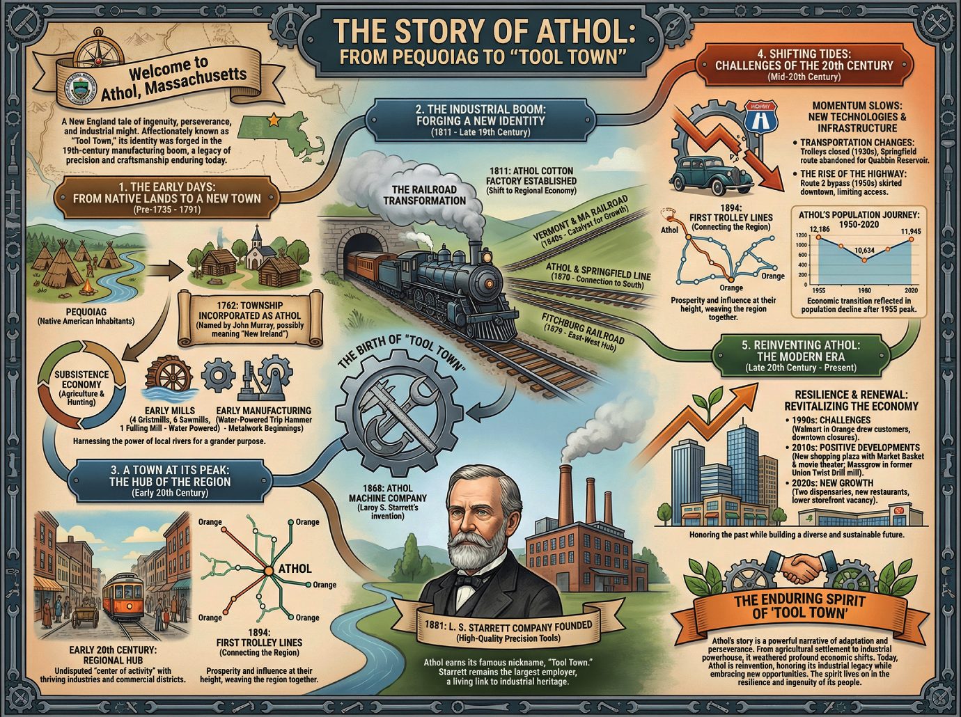
The Story of Athol: From Pequoiag to “Tool Town”
Introduction: Welcome to Athol, Massachusetts
Welcome to Athol, a town in the heart of Massachusetts whose story is etched into the very landscape of New England—a tale of ingenuity, perseverance, and industrial might. Known affectionately as “Tool Town,” Athol’s identity was forged in the fires of the 19th-century manufacturing boom, a legacy of precision and craftsmanship that endures to this day. This document will take you on a journey through time, exploring Athol’s evolution from its earliest days as a Native American settlement, through its rise as an industrial powerhouse, to the resilient community now navigating the 21st century.
——————————————————————————–
1. The Early Days: From Native Lands to a New Town
Before European settlement, the area we now know as Athol was called Pequoiag by its Native American inhabitants. The landscape began to change permanently in September 1735, when the first five European families arrived to put down roots. The small settlement grew, and in 1762, the township was officially incorporated. One of the land’s proprietors, John Murray, chose the name Athol; traditionally, this was believed to mean “New Ireland,” although some, including historian James E. Fraser, dispute this definition.
In these early years, life was a matter of subsistence, closely tied to the land. The economy was built on agriculture and hunting, but the power of the local rivers was quickly harnessed. By 1791, the town’s economic landscape included:
• Subsistence: Agriculture and hunting remained the primary means of survival for residents.
• Early Mills: The town was home to four gristmills, six sawmills, and a fulling mill, all powered by water.
• Early Manufacturing: A shop with a water-powered trip hammer signaled the beginnings of local metalwork.
But the water that powered these small mills would soon be harnessed for a far grander purpose, setting the stage for a transformation that would redefine Athol for a century to come.
2. The Industrial Boom: Forging a New Identity
The Mills and the Railroad
The shift from a local to a regional economy began in earnest with the establishment of the Athol Cotton Factory in 1811. It was one of the first local industries designed to serve a market beyond the immediate needs of the townspeople. This industrial spark, however, truly caught fire with the arrival of the railroad. The “iron horse” connected Athol to the wider world, bringing in raw materials and shipping out finished goods at an unprecedented scale.
The railroad’s impact was transformative, with three key lines cementing Athol’s industrial future:
1. Vermont and Massachusetts Railroad (1840s): This first line was the catalyst, fostering significant industrial growth and connecting Athol to the expanding national network.
2. Athol and Springfield Line (1870): The construction of this second major route provided a vital connection to the south, further expanding the town’s commercial reach.
3. Fitchburg Railroad (1879): As it made its way to the Hoosac Tunnel and the Berkshires, this crucial east-west line solidified Athol’s position as a transportation and industrial hub.
The Birth of “Tool Town”
Among the many companies that flourished during this era, one would come to define the town’s identity. In 1868, an inventor named Laroy S. Starrett helped establish the Athol Machine Company to manufacture a chopping machine he had created.
Just over a decade later, in 1881, Mr. Starrett founded his own enterprise: the L. S. Starrett Company. This new firm quickly became famous for producing high-quality precision tools, earning a reputation for excellence that spread far beyond New England. It is from the enduring success of this company that Athol earned its famous nickname, “Tool Town.” To this day, the L. S. Starrett Company remains the town’s largest employer, a living link to its industrial heritage.
Fueled by roaring factories and a web of iron rails, Athol steamed into the 20th century at the height of its prosperity and influence.
3. A Town at its Peak: The Hub of the Region
At the start of the 20th century, Athol was the undisputed “center of activity for the entire area.” Its thriving industries, commercial districts, and transportation links made it a regional hub. A clear symbol of this prosperity was the establishment of the first trolley lines in 1894. This efficient network connected Athol to the neighboring town of Orange and soon expanded to other surrounding communities, weaving the region together with threads of commerce and community.
Yet the same currents of progress that had carried the town to its zenith would, in time, change course and present a new century of profound challenges.
4. Shifting Tides: Challenges of the 20th Century
The momentum that carried Athol into the 20th century began to slow as new technologies and major infrastructure projects reshaped the American landscape. The town’s growth leveled off and eventually began to decline due to several key factors:
• Transportation Changes: The trolley lines, once a sign of modern efficiency, were closed in the 1930s as private automobiles became the preferred mode of travel. A further blow came when the Springfield railroad route was abandoned to make way for the creation of the Quabbin Reservoir.
• The Rise of the Highway: The construction of the Route 2 bypass in the 1950s skirted the town’s core, limiting direct access to the downtown business district. This was a local symptom of a national trend, as commerce became increasingly dependent on the vast Interstate Highway System, which often left older industrial towns like Athol at a disadvantage.
This period of economic transition was reflected in the town’s population. After decades of growth, the population reached a peak of 12,186 in 1955 before entering a period of decline.
Athol’s Population Journey: 1950-2020
| Year | Population |
|---|---|
| 1950 | 11,554 |
| 1955 | 12,186 (Peak) |
| 1960 | 11,637 |
| 1970 | 11,185 |
| 1980 | 10,634 (Low) |
| 1990 | 11,451 |
| 2000 | 11,299 |
| 2010 | 11,584 |
| 2020 | 11,945 |
After weathering these decades of change, the stage was set for a new chapter, one focused on resilience and renewal.
5. Reinventing Athol: The Modern Era
The economic decline that began in the 1950s continued through the end of the century. By 1998, the commercial vacancy rate in Athol had reached a staggering 18 percent. In response, local leaders and community groups began a concerted effort to revitalize the town’s economy and chart a new course for the 21st century.
These efforts have brought a mix of challenges and successes over the last few decades:
• 1990s: The arrival of a Walmart in neighboring Orange presented a significant challenge, drawing customers away from Athol’s traditional downtown and leading directly to the closure of several Main Street businesses.
• 2010s: This decade saw major positive developments, including the construction of a new shopping plaza anchored by a Market Basket and a movie theater. In a nod to its industrial past, a portion of the former Union Twist Drill mill was converted for use by Massgrow, a marijuana-growing facility.
• 2020s: The town has continued to see new growth with the opening of two dispensaries and several new restaurants. These new enterprises have contributed to a lower storefront vacancy rate on Main Street than in the previous decade.
These recent efforts reflect a community actively working to honor its past while building a diverse and sustainable future.
6. Conclusion: The Enduring Spirit of “Tool Town”
Athol’s story is a powerful New England narrative of adaptation and perseverance. From a small agricultural settlement, it rose to become an industrial powerhouse, a “Tool Town” whose name was synonymous with quality and innovation. It weathered the profound economic shifts of the 20th century—the eclipse of the railroad by the highway, the migration of commerce, and the hollowing of its downtown—and faced its challenges head-on. Today, Athol is a town in the midst of reinvention, honoring its industrial legacy while embracing new opportunities for growth. The enduring spirit of “Tool Town” lives on, not just in its largest employer, but in the resilience and ingenuity of its people as they forge the next chapter of Athol’s history.
4 Surprising Stories
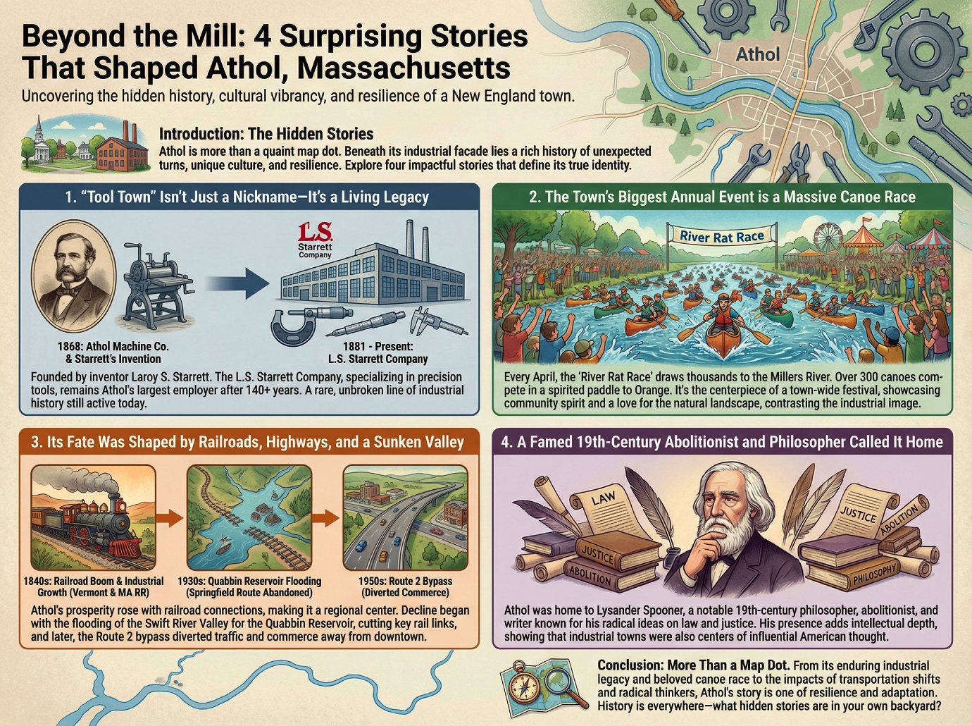
Beyond the Mill: 4 Surprising Stories That Shaped Athol, Massachusetts
Introduction: The Hidden Stories of a New England Town
Every small town has a story, but most of us drive through them without a second thought, seeing only a map dot with a quaint main street. We might notice the old brick factories or the classic town common and assume we know the whole narrative: a once-thriving industrial center that has settled into a quiet modern existence. On the surface, Athol, Massachusetts, seems to fit this mold perfectly.
But beneath the typical New England facade lies a history rich with unexpected turns, unique cultural expressions, and a resilience that defies simple categorization. This is a town shaped as much by roaring rivers and radical thinkers as it was by its famous factories. To truly understand a place like Athol, you have to look past the obvious and uncover the stories that give it a unique identity.
This article does just that. We’ll explore four of the most impactful and surprising takeaways from Athol’s history and culture—from its industrial legacy that is still very much alive, to a massive annual canoe race that defines its community spirit.
“Tool Town” Isn’t Just a Nickname—It’s a Living Legacy
Many towns have nicknames that are relics of a bygone era, but Athol’s moniker, “Tool Town,” is a direct reflection of its present-day identity. The story begins with an inventor named Laroy S. Starrett, who developed a novel chopping machine. This invention led to the establishment of the Athol Machine Company in 1868.
A few years later, in 1881, Mr. Starrett founded a new enterprise: the L. S. Starrett Company, which specialized in making high-quality precision tools. This company became the bedrock of Athol’s economy, cementing its reputation for industrial manufacturing.
The most remarkable part of this story is its continuity. Over 140 years later, the L. S. Starrett Company remains the town’s largest employer. This direct, unbroken line from its 19th-century industrial founding to its 21st-century economic reality is incredibly rare, making Athol a town where history isn’t just in a museum—it’s still on the factory floor.
The Town’s Biggest Annual Event is a Massive Canoe Race
While industry defines Athol’s economy, its cultural heart is perhaps best captured on the water. The town’s largest annual event isn’t a factory anniversary or a historical reenactment, but a massive canoe competition known as the “River Rat Race.”
Every April, this race draws thousands of spectators to the banks of the Millers River to watch over 300 canoes compete in a spirited paddle from Athol to the neighboring town of Orange. The race is the centerpiece of a town-wide celebration that includes a parade and a carnival, creating a festival atmosphere.
This event reveals a quirky and vibrant side of Athol that stands in stark contrast to its industrial “Tool Town” image. It showcases a community that has built its most cherished tradition around its natural landscape and a shared sense of fun, proving the town’s identity is far more eclectic than its history might suggest.
Its Fate Was Shaped by Railroads, Highways, and a Sunken Valley
Athol’s story is a powerful case study in how a town’s prosperity is directly tied to the dominant transportation networks of the day. Its economic journey is a dramatic narrative of infrastructure’s power to both create and divert fortune.
The rise began in the 1840s with the arrival of the Vermont and Massachusetts Railroad. This new connection fueled such immense industrial growth that two more rail lines were soon built, including a key link to Springfield. By the early 20th century, this confluence of industry and transportation had made Athol the undisputed “center of activity for the entire area.”
However, what technology gives, it can also take away. The town’s decline began when four nearby towns in the Swift River Valley were flooded to create the Quabbin Reservoir, forcing the abandonment of the critical Springfield railroad route. Decades later, in the 1950s, the construction of the Route 2 bypass delivered another blow, diverting automobile traffic and commerce away from the downtown business district. This history shows how Athol’s economic destiny was shaped not just by what was built within its borders, but by the shifting paths of progress around it.
A Famed 19th-Century Abolitionist and Philosopher Called It Home
You’d be forgiven for associating Athol strictly with wrenches and rulers. Yet, hidden in its civic history is a figure who forged not tools, but radical ideas that challenged the nation. Athol was once home to Lysander Spooner, a notable 19th-century “philosopher, abolitionist and writer.”
Spooner was a complex and influential figure, known for his writings on law, justice, and his staunch opposition to slavery. Finding his name on the list of Athol’s notable people adds an unexpected layer of intellectual depth to the town’s history.
The presence of a figure like Spooner complicates the simple narrative of a “Tool Town.” It’s a potent reminder that the history of American industry is inextricably linked to the history of American ideas—even radical ones—and that these forces often shaped the same small corners of the country.
Conclusion: More Than a Map Dot
From a 19th-century tool company that still anchors the local economy to a beloved canoe race that draws thousands, Athol is far more than a simple mill town. Its history is a complex story of industrial innovation, cultural vibrancy, and adaptation to the ever-changing currents of transportation and commerce. It proves that even the most unassuming places are rich with stories of resilience and identity.
Towns like Athol are a testament to the fact that history is everywhere, waiting just below the surface. What hidden histories are waiting to be discovered in your own backyard?