

Costs involved
Because of the relatively low power involved, cost would not be a huge factor as the transmitter and antenna would be fairly inexpensive. Engineering is relatively simple and the F.C.C. engineers in Washington D.C. could help for FREE. Gardner already has a television studio at the High School on Catherine Street. Gardner MA produces high quality video of City Council, School Committee, and other Municipal Meetings, and a weekly Mayor’s update. Visit the City of Gardner YouTube page here.
Gardner MA may consider its own Low Power Municipal Radio Station
Last year, an F.C.C. window closed on applications for regular licenses on the non-commercial band. Sometime soon, a window will open for additional low power FM applications on the 92 -108 part of the band. That’s where the interests of Gardner come in. Does Gardner want to have a station like the City of Leominster has had since January 26, 2017, which is licensed for 21 watts with an antenna 210 feet above average terrain? See what Leominster is doing with it. Website.
How Far would it Transmit?
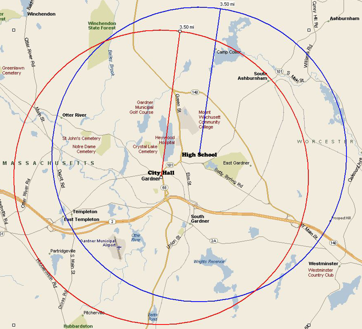
If the license was granted, Gardner High School on Catherine Street could serve as a transmitter site as it’s roughly in the middle of Gardner geographically. Gardner City Hall might also cover the City. According to the Federal Communications Commission, Low power FM has a radius of about 3.5 miles. Gardner is only 23 square miles which in this case presents an advantage – less square footage to cover with a transmitter. The calculated coverage area would be A=πr2=π·3.52≈38.48451mi² using 3.5 as the radius of a circle and calculating the area of the circle. The math shows much of the Chair City could be covered, perfect for emergencies or whatever Gardner would deem to be in its interests. Due to the low power, the coverage might have dead spots due to terrain. That is why commercial stations which cover more than one community operate with substantially more power.
We asked the Mayor in an interview on many subjects July 6th:
Poegel: “Mayor, so sometime soon, an FCC window is going to open, allowing the City of Gardner to apply for a low power FM license, similar to what the City of Leominster already has. Does the Chair City have an interest in pursuing this to protect its interests?”
Nicholson: “I know we’ve talked about that with our Emergency Management Director Paul Topolski, because we do have a radio transmitter that we can use when we have larger events, but we don’t have a signal that is our own. So it is something we preliminarily looked at, but it’s not something we’ve had on the radar until we just heard the rumblings that the F.C.C. might be opening up a little more, so it’s a very recent conversation that we don’t have any details on yet on our end, but it is something that did spark a conversation.” Listen to the entire interview.
What frequency would it be?
Low power FM is between 92 and 108 on the FM dial. You find out what’s available by doing a search on the FCC website. You need to know the latitude and longitude of the proposed transmitter location. Finding a frequency is as simple as going on the F.C.C. site, inputting latitude and longitude specs, and doing a search. Gardner City Hall at 95 Pleasant Street is at 42 34 26, -71 59 45 and Gardner High School is at 42 34 39, -71 58 45. Both searches yield the same available frequencies, 97.3 and 102.9. However, Steve Wendell, owner of WGAW has a construction permit for a commercial station at the 97.3 frequency for Orange MA, so our bet is the City would pick 102.9 if it’s interested in pursuing the project.
As the Crow Flies
If we each had a flying car, we could make it to work much quicker because the distance “As the Crow Flies” is always shorter. There’s an online tool to calculate the straight line distance between two locations. CLICK HERE.
.
